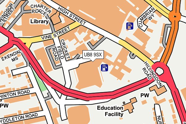
UB8 9SX is located in the Uxbridge electoral ward, within the London borough of Hillingdon and the English Parliamentary constituency of Uxbridge and South Ruislip. The Sub Integrated Care Board (ICB) Location is NHS North West London ICB - W2U3Z and the police force is Metropolitan Police. This postcode has been in use since March 2005.


GetTheData
Source: OS OpenMap – Local (Ordnance Survey)
Source: OS VectorMap District (Ordnance Survey)
Licence: Open Government Licence (requires attribution)
| Easting | 505739 |
| Northing | 183871 |
| Latitude | 51.543839 |
| Longitude | -0.476598 |
GetTheData
Source: Open Postcode Geo
Licence: Open Government Licence
| Country | England |
| Postcode District | UB8 |
➜ See where UB8 is on a map ➜ Where is London? | |
GetTheData
Source: Land Registry Price Paid Data
Licence: Open Government Licence
Elevation or altitude of UB8 9SX as distance above sea level:
| Metres | Feet | |
|---|---|---|
| Elevation | 40m | 131ft |
Elevation is measured from the approximate centre of the postcode, to the nearest point on an OS contour line from OS Terrain 50, which has contour spacing of ten vertical metres.
➜ How high above sea level am I? Find the elevation of your current position using your device's GPS.
GetTheData
Source: Open Postcode Elevation
Licence: Open Government Licence
| Ward | Uxbridge |
| Constituency | Uxbridge And South Ruislip |
GetTheData
Source: ONS Postcode Database
Licence: Open Government Licence
| Civic Centre | Uxbridge | 94m |
| Vine Street | Uxbridge | 136m |
| Park Road Uxbridge (Park Road) | Uxbridge | 263m |
| St Andrew's Church (Ub8) (Hillingdon Road) | Uxbridge | 274m |
| Uxbridge | Uxbridge | 304m |
| Uxbridge Underground Station | Uxbridge | 317m |
| West Drayton Station | 3.8km |
| West Ruislip Station | 3.9km |
| Denham Station | 4.2km |
GetTheData
Source: NaPTAN
Licence: Open Government Licence
GetTheData
Source: ONS Postcode Database
Licence: Open Government Licence


➜ Get more ratings from the Food Standards Agency
GetTheData
Source: Food Standards Agency
Licence: FSA terms & conditions
| Last Collection | |||
|---|---|---|---|
| Location | Mon-Fri | Sat | Distance |
| Metropolitan Station | 19:00 | 13:00 | 324m |
| Wellington Road | 18:30 | 12:15 | 362m |
| Manor Waye | 18:15 | 12:45 | 440m |
GetTheData
Source: Dracos
Licence: Creative Commons Attribution-ShareAlike
The below table lists the International Territorial Level (ITL) codes (formerly Nomenclature of Territorial Units for Statistics (NUTS) codes) and Local Administrative Units (LAU) codes for UB8 9SX:
| ITL 1 Code | Name |
|---|---|
| TLI | London |
| ITL 2 Code | Name |
| TLI7 | Outer London - West and North West |
| ITL 3 Code | Name |
| TLI74 | Harrow and Hillingdon |
| LAU 1 Code | Name |
| E09000017 | Hillingdon |
GetTheData
Source: ONS Postcode Directory
Licence: Open Government Licence
The below table lists the Census Output Area (OA), Lower Layer Super Output Area (LSOA), and Middle Layer Super Output Area (MSOA) for UB8 9SX:
| Code | Name | |
|---|---|---|
| OA | E00012551 | |
| LSOA | E01033725 | Hillingdon 015F |
| MSOA | E02000508 | Hillingdon 015 |
GetTheData
Source: ONS Postcode Directory
Licence: Open Government Licence
| UB8 1QG | Cricketfield Road | 114m |
| UB8 1LB | High Street | 135m |
| UB8 1LD | High Street | 141m |
| UB8 1LE | High Street | 177m |
| UB8 1XD | Cumbrian Way | 205m |
| UB8 1JN | High Street | 212m |
| UB8 2NZ | Whitehall Road | 213m |
| UB8 1XE | Ambleside Walk | 217m |
| UB8 2DF | Whitehall Road | 224m |
| UB8 2BE | Manor Waye | 240m |
GetTheData
Source: Open Postcode Geo; Land Registry Price Paid Data
Licence: Open Government Licence