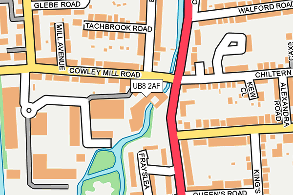
UB8 2AF is located in the Uxbridge electoral ward, within the London borough of Hillingdon and the English Parliamentary constituency of Uxbridge and South Ruislip. The Sub Integrated Care Board (ICB) Location is NHS North West London ICB - W2U3Z and the police force is Metropolitan Police. This postcode has been in use since January 1980.


GetTheData
Source: OS OpenMap – Local (Ordnance Survey)
Source: OS VectorMap District (Ordnance Survey)
Licence: Open Government Licence (requires attribution)
| Easting | 505293 |
| Northing | 183174 |
| Latitude | 51.537658 |
| Longitude | -0.483235 |
GetTheData
Source: Open Postcode Geo
Licence: Open Government Licence
| Country | England |
| Postcode District | UB8 |
➜ See where UB8 is on a map ➜ Where is London? | |
GetTheData
Source: Land Registry Price Paid Data
Licence: Open Government Licence
Elevation or altitude of UB8 2AF as distance above sea level:
| Metres | Feet | |
|---|---|---|
| Elevation | 30m | 98ft |
Elevation is measured from the approximate centre of the postcode, to the nearest point on an OS contour line from OS Terrain 50, which has contour spacing of ten vertical metres.
➜ How high above sea level am I? Find the elevation of your current position using your device's GPS.
GetTheData
Source: Open Postcode Elevation
Licence: Open Government Licence
| Ward | Uxbridge |
| Constituency | Uxbridge And South Ruislip |
GetTheData
Source: ONS Postcode Database
Licence: Open Government Licence
| Cowley Mill Road | Uxbridge Moor | 99m |
| Cowley Mill Road | Uxbridge Moor | 111m |
| Ferndale Crescent | Cowley | 317m |
| Whitehall School | Uxbridge | 341m |
| Whitehall School | Uxbridge | 392m |
| Uxbridge Underground Station | Uxbridge | 1,056m |
| West Drayton Station | 3.2km |
| Iver Station | 3.6km |
| Denham Station | 4.7km |
GetTheData
Source: NaPTAN
Licence: Open Government Licence
GetTheData
Source: ONS Postcode Database
Licence: Open Government Licence


➜ Get more ratings from the Food Standards Agency
GetTheData
Source: Food Standards Agency
Licence: FSA terms & conditions
| Last Collection | |||
|---|---|---|---|
| Location | Mon-Fri | Sat | Distance |
| Cowley Road | 18:45 | 12:45 | 77m |
| Uxbridge Delivery Office | 19:30 | 265m | |
| Uxbridge Delivery Office | 19:30 | 12:30 | 267m |
GetTheData
Source: Dracos
Licence: Creative Commons Attribution-ShareAlike
The below table lists the International Territorial Level (ITL) codes (formerly Nomenclature of Territorial Units for Statistics (NUTS) codes) and Local Administrative Units (LAU) codes for UB8 2AF:
| ITL 1 Code | Name |
|---|---|
| TLI | London |
| ITL 2 Code | Name |
| TLI7 | Outer London - West and North West |
| ITL 3 Code | Name |
| TLI74 | Harrow and Hillingdon |
| LAU 1 Code | Name |
| E09000017 | Hillingdon |
GetTheData
Source: ONS Postcode Directory
Licence: Open Government Licence
The below table lists the Census Output Area (OA), Lower Layer Super Output Area (LSOA), and Middle Layer Super Output Area (MSOA) for UB8 2AF:
| Code | Name | |
|---|---|---|
| OA | E00012549 | |
| LSOA | E01033724 | Hillingdon 016F |
| MSOA | E02000509 | Hillingdon 016 |
GetTheData
Source: ONS Postcode Directory
Licence: Open Government Licence
| UB8 2LZ | Cowley Road | 75m |
| UB8 2QB | Cowley Mill Road | 111m |
| UB8 2QN | Bridge Road | 113m |
| UB8 2LR | Medman Close | 119m |
| UB8 2LY | Cowley Road | 130m |
| UB8 2AT | Frays Lea | 157m |
| UB8 2QS | Tachbrook Road | 158m |
| UB8 2NH | Cowley Road | 172m |
| UB8 2DB | Cowley Mill Road | 174m |
| UB8 2PA | Chiltern View Road | 175m |
GetTheData
Source: Open Postcode Geo; Land Registry Price Paid Data
Licence: Open Government Licence