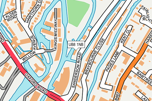
UB8 1NB is located in the Denham electoral ward, within the unitary authority of Buckinghamshire and the English Parliamentary constituency of Beaconsfield. The Sub Integrated Care Board (ICB) Location is NHS Buckinghamshire, Oxfordshire and Berkshire West ICB - 14Y and the police force is Thames Valley. This postcode has been in use since January 1980.


GetTheData
Source: OS OpenMap – Local (Ordnance Survey)
Source: OS VectorMap District (Ordnance Survey)
Licence: Open Government Licence (requires attribution)
| Easting | 505282 |
| Northing | 184748 |
| Latitude | 51.551808 |
| Longitude | -0.482923 |
GetTheData
Source: Open Postcode Geo
Licence: Open Government Licence
| Country | England |
| Postcode District | UB8 |
➜ See where UB8 is on a map ➜ Where is London? | |
GetTheData
Source: Land Registry Price Paid Data
Licence: Open Government Licence
Elevation or altitude of UB8 1NB as distance above sea level:
| Metres | Feet | |
|---|---|---|
| Elevation | 40m | 131ft |
Elevation is measured from the approximate centre of the postcode, to the nearest point on an OS contour line from OS Terrain 50, which has contour spacing of ten vertical metres.
➜ How high above sea level am I? Find the elevation of your current position using your device's GPS.
GetTheData
Source: Open Postcode Elevation
Licence: Open Government Licence
| Ward | Denham |
| Constituency | Beaconsfield |
GetTheData
Source: ONS Postcode Database
Licence: Open Government Licence
| Oakside (Oxford Road) | New Denham | 342m |
| Oakside (Oxford Road) | New Denham | 422m |
| Uxbridge High Street | Uxbridge | 426m |
| Uxbridge High Street | Uxbridge | 442m |
| Uxbridge High Street | Uxbridge | 490m |
| Uxbridge Underground Station | Uxbridge | 678m |
| Denham Station | 3.2km |
| West Ruislip Station | 3.7km |
| Denham Golf Club Station | 4km |
GetTheData
Source: NaPTAN
Licence: Open Government Licence
GetTheData
Source: ONS Postcode Database
Licence: Open Government Licence


➜ Get more ratings from the Food Standards Agency
GetTheData
Source: Food Standards Agency
Licence: FSA terms & conditions
| Last Collection | |||
|---|---|---|---|
| Location | Mon-Fri | Sat | Distance |
| Oxford Road | 18:30 | 12:00 | 233m |
| Harefield Road South | 18:45 | 12:45 | 351m |
| High Street | 18:30 | 12:45 | 511m |
GetTheData
Source: Dracos
Licence: Creative Commons Attribution-ShareAlike
The below table lists the International Territorial Level (ITL) codes (formerly Nomenclature of Territorial Units for Statistics (NUTS) codes) and Local Administrative Units (LAU) codes for UB8 1NB:
| ITL 1 Code | Name |
|---|---|
| TLJ | South East (England) |
| ITL 2 Code | Name |
| TLJ1 | Berkshire, Buckinghamshire and Oxfordshire |
| ITL 3 Code | Name |
| TLJ13 | Buckinghamshire |
| LAU 1 Code | Name |
| E06000060 | Buckinghamshire |
GetTheData
Source: ONS Postcode Directory
Licence: Open Government Licence
The below table lists the Census Output Area (OA), Lower Layer Super Output Area (LSOA), and Middle Layer Super Output Area (MSOA) for UB8 1NB:
| Code | Name | |
|---|---|---|
| OA | E00089880 | |
| LSOA | E01017813 | South Bucks 003D |
| MSOA | E02003690 | South Bucks 003 |
GetTheData
Source: ONS Postcode Directory
Licence: Open Government Licence
| UB8 1UH | Braybourne Close | 54m |
| UB9 4BT | Kings Mill Way | 76m |
| UB8 1UL | Braybourne Close | 86m |
| UB9 4BS | Kings Mill Way | 126m |
| UB8 1XT | Pages Lane | 135m |
| UB9 4AA | Denham Lodge | 163m |
| UB9 4AB | Denham Lodge | 163m |
| UB9 4AF | Willow Avenue | 190m |
| UB8 1PJ | Harefield Road | 198m |
| UB9 4AJ | Hawthorn Drive | 209m |
GetTheData
Source: Open Postcode Geo; Land Registry Price Paid Data
Licence: Open Government Licence