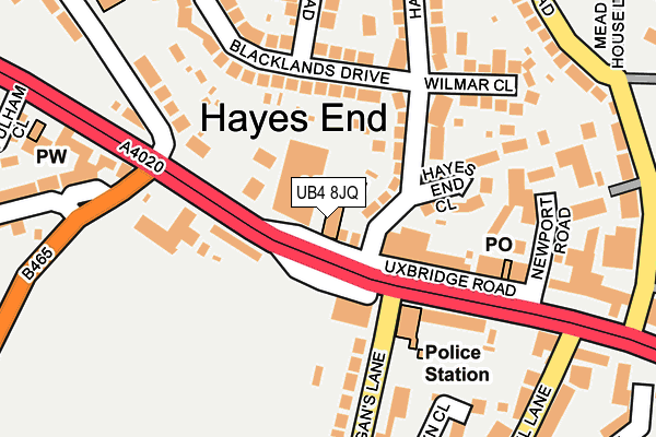
UB4 8JQ is located in the Charville electoral ward, within the London borough of Hillingdon and the English Parliamentary constituency of Hayes and Harlington. The Sub Integrated Care Board (ICB) Location is NHS North West London ICB - W2U3Z and the police force is Metropolitan Police. This postcode has been in use since January 1980.


GetTheData
Source: OS OpenMap – Local (Ordnance Survey)
Source: OS VectorMap District (Ordnance Survey)
Licence: Open Government Licence (requires attribution)
| Easting | 508588 |
| Northing | 181944 |
| Latitude | 51.525979 |
| Longitude | -0.436124 |
GetTheData
Source: Open Postcode Geo
Licence: Open Government Licence
| Country | England |
| Postcode District | UB4 |
➜ See where UB4 is on a map ➜ Where is Hayes? | |
GetTheData
Source: Land Registry Price Paid Data
Licence: Open Government Licence
Elevation or altitude of UB4 8JQ as distance above sea level:
| Metres | Feet | |
|---|---|---|
| Elevation | 40m | 131ft |
Elevation is measured from the approximate centre of the postcode, to the nearest point on an OS contour line from OS Terrain 50, which has contour spacing of ten vertical metres.
➜ How high above sea level am I? Find the elevation of your current position using your device's GPS.
GetTheData
Source: Open Postcode Elevation
Licence: Open Government Licence
| Ward | Charville |
| Constituency | Hayes And Harlington |
GetTheData
Source: ONS Postcode Database
Licence: Open Government Licence
| Morgans Lane Uxbridge Road (Uxbridge Road) | Hayes End | 45m |
| Hayes Police Station (Uxbridge Road) | Hayes End | 157m |
| New Road West Drayton Road (West Drayton Road) | Hayes End | 207m |
| Hewens Road (Uxbridge Road) | Hayes End | 239m |
| Mellow Lane School | Hayes End | 262m |
| Hayes & Harlington Station | 2.8km |
| West Drayton Station | 3.1km |
| South Ruislip Station | 4.3km |
GetTheData
Source: NaPTAN
Licence: Open Government Licence
Estimated total energy consumption in UB4 8JQ by fuel type, 2015.
| Consumption (kWh) | 27,443 |
|---|---|
| Meter count | 7 |
| Mean (kWh/meter) | 3,920 |
| Median (kWh/meter) | 3,463 |
GetTheData
Source: Postcode level gas estimates: 2015 (experimental)
Source: Postcode level electricity estimates: 2015 (experimental)
Licence: Open Government Licence
GetTheData
Source: ONS Postcode Database
Licence: Open Government Licence


➜ Get more ratings from the Food Standards Agency
GetTheData
Source: Food Standards Agency
Licence: FSA terms & conditions
| Last Collection | |||
|---|---|---|---|
| Location | Mon-Fri | Sat | Distance |
| Harlington Road Post Office | 17:00 | 12:30 | 842m |
| 32 Corwell Lane | 16:45 | 12:30 | 876m |
| Lees Road | 16:45 | 12:30 | 964m |
GetTheData
Source: Dracos
Licence: Creative Commons Attribution-ShareAlike
The below table lists the International Territorial Level (ITL) codes (formerly Nomenclature of Territorial Units for Statistics (NUTS) codes) and Local Administrative Units (LAU) codes for UB4 8JQ:
| ITL 1 Code | Name |
|---|---|
| TLI | London |
| ITL 2 Code | Name |
| TLI7 | Outer London - West and North West |
| ITL 3 Code | Name |
| TLI74 | Harrow and Hillingdon |
| LAU 1 Code | Name |
| E09000017 | Hillingdon |
GetTheData
Source: ONS Postcode Directory
Licence: Open Government Licence
The below table lists the Census Output Area (OA), Lower Layer Super Output Area (LSOA), and Middle Layer Super Output Area (MSOA) for UB4 8JQ:
| Code | Name | |
|---|---|---|
| OA | E00012084 | |
| LSOA | E01002423 | Hillingdon 018B |
| MSOA | E02000511 | Hillingdon 018 |
GetTheData
Source: ONS Postcode Directory
Licence: Open Government Licence
| UB4 8HW | Uxbridge Road | 0m |
| UB4 8HY | Uxbridge Road | 80m |
| UB4 8HZ | Uxbridge Road | 89m |
| UB4 8HB | Hayes End Drive | 90m |
| UB4 8JG | Uxbridge Road | 95m |
| UB4 8HF | Hayes End Close | 114m |
| UB4 8EU | Blacklands Drive | 119m |
| UB4 8HX | Uxbridge Road | 156m |
| UB4 8JF | Uxbridge Road | 171m |
| UB4 8HG | Pillions Lane | 180m |
GetTheData
Source: Open Postcode Geo; Land Registry Price Paid Data
Licence: Open Government Licence