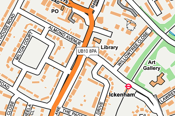
UB10 8PA is located in the Ickenham & South Harefield electoral ward, within the London borough of Hillingdon and the English Parliamentary constituency of Ruislip, Northwood and Pinner. The Sub Integrated Care Board (ICB) Location is NHS North West London ICB - W2U3Z and the police force is Metropolitan Police. This postcode has been in use since January 1980.


GetTheData
Source: OS OpenMap – Local (Ordnance Survey)
Source: OS VectorMap District (Ordnance Survey)
Licence: Open Government Licence (requires attribution)
| Easting | 507956 |
| Northing | 186043 |
| Latitude | 51.562942 |
| Longitude | -0.443974 |
GetTheData
Source: Open Postcode Geo
Licence: Open Government Licence
| Country | England |
| Postcode District | UB10 |
➜ See where UB10 is on a map ➜ Where is London? | |
GetTheData
Source: Land Registry Price Paid Data
Licence: Open Government Licence
Elevation or altitude of UB10 8PA as distance above sea level:
| Metres | Feet | |
|---|---|---|
| Elevation | 40m | 131ft |
Elevation is measured from the approximate centre of the postcode, to the nearest point on an OS contour line from OS Terrain 50, which has contour spacing of ten vertical metres.
➜ How high above sea level am I? Find the elevation of your current position using your device's GPS.
GetTheData
Source: Open Postcode Elevation
Licence: Open Government Licence
| Ward | Ickenham & South Harefield |
| Constituency | Ruislip, Northwood And Pinner |
GetTheData
Source: ONS Postcode Database
Licence: Open Government Licence
| Glebe Avenue Ickenham Station | Ickenham | 36m |
| Ickenham | Ickenham | 37m |
| Ickenham | Ickenham | 102m |
| Ickenham | Ickenham | 122m |
| Ickenham Pump | Ickenham | 169m |
| Ickenham Underground Station | Ickenham | 173m |
| West Ruislip Underground Station | West Ruislip | 861m |
| Hillingdon Underground Station | North Hillingdon | 1,104m |
| West Ruislip Station | 0.9km |
| South Ruislip Station | 3.2km |
| Denham Station | 4.1km |
GetTheData
Source: NaPTAN
Licence: Open Government Licence
GetTheData
Source: ONS Postcode Database
Licence: Open Government Licence


➜ Get more ratings from the Food Standards Agency
GetTheData
Source: Food Standards Agency
Licence: FSA terms & conditions
| Last Collection | |||
|---|---|---|---|
| Location | Mon-Fri | Sat | Distance |
| Warren Road | 18:00 | 12:45 | 298m |
| Glebe Avenue | 18:00 | 13:00 | 380m |
| Parkfield Avenue | 18:00 | 12:45 | 791m |
GetTheData
Source: Dracos
Licence: Creative Commons Attribution-ShareAlike
The below table lists the International Territorial Level (ITL) codes (formerly Nomenclature of Territorial Units for Statistics (NUTS) codes) and Local Administrative Units (LAU) codes for UB10 8PA:
| ITL 1 Code | Name |
|---|---|
| TLI | London |
| ITL 2 Code | Name |
| TLI7 | Outer London - West and North West |
| ITL 3 Code | Name |
| TLI74 | Harrow and Hillingdon |
| LAU 1 Code | Name |
| E09000017 | Hillingdon |
GetTheData
Source: ONS Postcode Directory
Licence: Open Government Licence
The below table lists the Census Output Area (OA), Lower Layer Super Output Area (LSOA), and Middle Layer Super Output Area (MSOA) for UB10 8PA:
| Code | Name | |
|---|---|---|
| OA | E00012266 | |
| LSOA | E01002460 | Hillingdon 011C |
| MSOA | E02000504 | Hillingdon 011 |
GetTheData
Source: ONS Postcode Directory
Licence: Open Government Licence
| UB10 8PB | Glebe Avenue | 22m |
| UB10 8QX | Long Lane | 57m |
| UB10 8TA | Long Lane | 78m |
| UB10 8TB | Long Lane | 126m |
| UB10 8QZ | Edinburgh Drive | 126m |
| UB10 8QU | Long Lane | 133m |
| UB10 8ND | Milton Court | 158m |
| UB10 8NA | Almond Avenue | 161m |
| UB10 8RD | Willow Tree Close | 163m |
| UB10 8DF | Swakeleys Road | 182m |
GetTheData
Source: Open Postcode Geo; Land Registry Price Paid Data
Licence: Open Government Licence