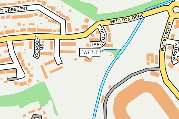
TW7 7LT is located in the Whitton electoral ward, within the London borough of Richmond upon Thames and the English Parliamentary constituency of Twickenham. The Sub Integrated Care Board (ICB) Location is NHS South West London ICB - 36L and the police force is Metropolitan Police. This postcode has been in use since January 1980.


GetTheData
Source: OS OpenMap – Local (Ordnance Survey)
Source: OS VectorMap District (Ordnance Survey)
Licence: Open Government Licence (requires attribution)
| Easting | 515125 |
| Northing | 174501 |
| Latitude | 51.457790 |
| Longitude | -0.344361 |
GetTheData
Source: Open Postcode Geo
Licence: Open Government Licence
| Country | England |
| Postcode District | TW7 |
➜ See where TW7 is on a map ➜ Where is London? | |
GetTheData
Source: Land Registry Price Paid Data
Licence: Open Government Licence
Elevation or altitude of TW7 7LT as distance above sea level:
| Metres | Feet | |
|---|---|---|
| Elevation | 10m | 33ft |
Elevation is measured from the approximate centre of the postcode, to the nearest point on an OS contour line from OS Terrain 50, which has contour spacing of ten vertical metres.
➜ How high above sea level am I? Find the elevation of your current position using your device's GPS.
GetTheData
Source: Open Postcode Elevation
Licence: Open Government Licence
| Ward | Whitton |
| Constituency | Twickenham |
GetTheData
Source: ONS Postcode Database
Licence: Open Government Licence
| Varsity Drive (Rugby Road) | St Margarets | 241m |
| Twickenham Stadium | St Margarets | 282m |
| Twickenham Stadium | St Margarets | 283m |
| Twickenham Trading Estate | Twickenham | 290m |
| Varsity Drive (Rugby Road) | St Margarets | 308m |
| Whitton Station | 1.3km |
| Twickenham Station | 1.3km |
| Hounslow Station | 1.3km |
GetTheData
Source: NaPTAN
Licence: Open Government Licence
GetTheData
Source: ONS Postcode Database
Licence: Open Government Licence

➜ Get more ratings from the Food Standards Agency
GetTheData
Source: Food Standards Agency
Licence: FSA terms & conditions
| Last Collection | |||
|---|---|---|---|
| Location | Mon-Fri | Sat | Distance |
| Kneller Gardens | 17:45 | 12:30 | 280m |
| Tesco Stores, Mogden Lane | 18:00 | 12:15 | 450m |
| Whitton Road | 17:00 | 11:00 | 482m |
GetTheData
Source: Dracos
Licence: Creative Commons Attribution-ShareAlike
The below table lists the International Territorial Level (ITL) codes (formerly Nomenclature of Territorial Units for Statistics (NUTS) codes) and Local Administrative Units (LAU) codes for TW7 7LT:
| ITL 1 Code | Name |
|---|---|
| TLI | London |
| ITL 2 Code | Name |
| TLI7 | Outer London - West and North West |
| ITL 3 Code | Name |
| TLI75 | Hounslow and Richmond upon Thames |
| LAU 1 Code | Name |
| E09000027 | Richmond upon Thames |
GetTheData
Source: ONS Postcode Directory
Licence: Open Government Licence
The below table lists the Census Output Area (OA), Lower Layer Super Output Area (LSOA), and Middle Layer Super Output Area (MSOA) for TW7 7LT:
| Code | Name | |
|---|---|---|
| OA | E00019662 | |
| LSOA | E01003905 | Richmond upon Thames 010A |
| MSOA | E02000793 | Richmond upon Thames 010 |
GetTheData
Source: ONS Postcode Directory
Licence: Open Government Licence
| TW7 7LA | Harlequin Close | 72m |
| TW7 7LX | Regency Mews | 79m |
| TW7 7LY | Queensbridge Park | 139m |
| TW7 7LZ | Yeomans Mews | 140m |
| TW7 7NB | Queensbridge Park | 140m |
| TW7 7LU | Whitton Dene | 193m |
| TW7 7NA | Consort Mews | 206m |
| TW7 7NR | Kneller Gardens | 215m |
| TW7 7NU | Arnold Crescent | 229m |
| TW7 7ND | Whitton Dene | 246m |
GetTheData
Source: Open Postcode Geo; Land Registry Price Paid Data
Licence: Open Government Licence