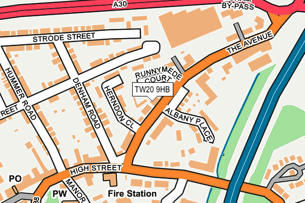
TW20 9HB is located in the Egham Town electoral ward, within the local authority district of Runnymede and the English Parliamentary constituency of Runnymede and Weybridge. The Sub Integrated Care Board (ICB) Location is NHS Surrey Heartlands ICB - 92A and the police force is Surrey. This postcode has been in use since June 2000.


GetTheData
Source: OS OpenMap – Local (Ordnance Survey)
Source: OS VectorMap District (Ordnance Survey)
Licence: Open Government Licence (requires attribution)
| Easting | 501469 |
| Northing | 171571 |
| Latitude | 51.434063 |
| Longitude | -0.541682 |
GetTheData
Source: Open Postcode Geo
Licence: Open Government Licence
| Country | England |
| Postcode District | TW20 |
➜ See where TW20 is on a map ➜ Where is Egham? | |
GetTheData
Source: Land Registry Price Paid Data
Licence: Open Government Licence
Elevation or altitude of TW20 9HB as distance above sea level:
| Metres | Feet | |
|---|---|---|
| Elevation | 20m | 66ft |
Elevation is measured from the approximate centre of the postcode, to the nearest point on an OS contour line from OS Terrain 50, which has contour spacing of ten vertical metres.
➜ How high above sea level am I? Find the elevation of your current position using your device's GPS.
GetTheData
Source: Open Postcode Elevation
Licence: Open Government Licence
| Ward | Egham Town |
| Constituency | Runnymede And Weybridge |
GetTheData
Source: ONS Postcode Database
Licence: Open Government Licence
| The Avenue | Egham | 175m |
| High Street | Egham | 204m |
| Pooley Green Crossing (Vicarage Road) | Egham | 205m |
| The Avenue | Egham | 233m |
| High Street | Egham | 253m |
| Egham Station | 0.6km |
| Wraysbury Station | 2.6km |
| Staines Station | 2.7km |
GetTheData
Source: NaPTAN
Licence: Open Government Licence
GetTheData
Source: ONS Postcode Database
Licence: Open Government Licence


➜ Get more ratings from the Food Standards Agency
GetTheData
Source: Food Standards Agency
Licence: FSA terms & conditions
| Last Collection | |||
|---|---|---|---|
| Location | Mon-Fri | Sat | Distance |
| Police Station, High Street | 18:30 | 10:45 | 86m |
| Manor Farm Lane | 17:30 | 11:00 | 254m |
| Crown Street | 18:30 | 11:00 | 301m |
GetTheData
Source: Dracos
Licence: Creative Commons Attribution-ShareAlike
| Risk of TW20 9HB flooding from rivers and sea | Low |
| ➜ TW20 9HB flood map | |
GetTheData
Source: Open Flood Risk by Postcode
Licence: Open Government Licence
The below table lists the International Territorial Level (ITL) codes (formerly Nomenclature of Territorial Units for Statistics (NUTS) codes) and Local Administrative Units (LAU) codes for TW20 9HB:
| ITL 1 Code | Name |
|---|---|
| TLJ | South East (England) |
| ITL 2 Code | Name |
| TLJ2 | Surrey, East and West Sussex |
| ITL 3 Code | Name |
| TLJ25 | West Surrey |
| LAU 1 Code | Name |
| E07000212 | Runnymede |
GetTheData
Source: ONS Postcode Directory
Licence: Open Government Licence
The below table lists the Census Output Area (OA), Lower Layer Super Output Area (LSOA), and Middle Layer Super Output Area (MSOA) for TW20 9HB:
| Code | Name | |
|---|---|---|
| OA | E00167795 | |
| LSOA | E01030668 | Runnymede 001B |
| MSOA | E02006393 | Runnymede 001 |
GetTheData
Source: ONS Postcode Directory
Licence: Open Government Licence
| TW20 9AA | Runnymede Court | 27m |
| TW20 9GP | Albany Place | 52m |
| TW20 9DE | Herndon Close | 66m |
| TW20 9HQ | High Street | 78m |
| TW20 9DB | Cedar Court | 85m |
| TW20 9AZ | The Avenue | 97m |
| TW20 9HG | Albany Place | 105m |
| TW20 9HA | Orchid Court | 108m |
| TW20 9DF | Denham Road | 112m |
| TW20 9HH | High Street | 116m |
GetTheData
Source: Open Postcode Geo; Land Registry Price Paid Data
Licence: Open Government Licence