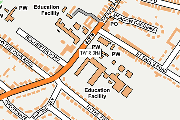
TW18 3HJ is located in the Egham Hythe electoral ward, within the local authority district of Runnymede and the English Parliamentary constituency of Runnymede and Weybridge. The Sub Integrated Care Board (ICB) Location is NHS Surrey Heartlands ICB - 92A and the police force is Surrey. This postcode has been in use since January 1980.


GetTheData
Source: OS OpenMap – Local (Ordnance Survey)
Source: OS VectorMap District (Ordnance Survey)
Licence: Open Government Licence (requires attribution)
| Easting | 502821 |
| Northing | 170954 |
| Latitude | 51.428274 |
| Longitude | -0.522418 |
GetTheData
Source: Open Postcode Geo
Licence: Open Government Licence
| Country | England |
| Postcode District | TW18 |
➜ See where TW18 is on a map ➜ Where is Egham? | |
GetTheData
Source: Land Registry Price Paid Data
Licence: Open Government Licence
Elevation or altitude of TW18 3HJ as distance above sea level:
| Metres | Feet | |
|---|---|---|
| Elevation | 20m | 66ft |
Elevation is measured from the approximate centre of the postcode, to the nearest point on an OS contour line from OS Terrain 50, which has contour spacing of ten vertical metres.
➜ How high above sea level am I? Find the elevation of your current position using your device's GPS.
GetTheData
Source: Open Postcode Elevation
Licence: Open Government Licence
| Ward | Egham Hythe |
| Constituency | Runnymede And Weybridge |
GetTheData
Source: ONS Postcode Database
Licence: Open Government Licence
| Magna Carta School (Thorpe Road) | Egham Hythe | 66m |
| Wendover Road (Thorpe Road) | Egham Hythe | 142m |
| Magna Carta School (Thorpe Lea Road) | Egham Hythe | 187m |
| Wendover Road (Thorpe Road) | Egham Hythe | 232m |
| Glebe Road (Thorpe Lea Road) | Egham Hythe | 383m |
| Staines Station | 1.4km |
| Egham Station | 1.7km |
| Wraysbury Station | 3.5km |
GetTheData
Source: NaPTAN
Licence: Open Government Licence
GetTheData
Source: ONS Postcode Database
Licence: Open Government Licence


➜ Get more ratings from the Food Standards Agency
GetTheData
Source: Food Standards Agency
Licence: FSA terms & conditions
| Last Collection | |||
|---|---|---|---|
| Location | Mon-Fri | Sat | Distance |
| Thorpe Road | 18:30 | 11:00 | 160m |
| Wendover Place | 18:30 | 11:00 | 426m |
| Pooley Green Road | 18:30 | 11:45 | 430m |
GetTheData
Source: Dracos
Licence: Creative Commons Attribution-ShareAlike
| Risk of TW18 3HJ flooding from rivers and sea | Low |
| ➜ TW18 3HJ flood map | |
GetTheData
Source: Open Flood Risk by Postcode
Licence: Open Government Licence
The below table lists the International Territorial Level (ITL) codes (formerly Nomenclature of Territorial Units for Statistics (NUTS) codes) and Local Administrative Units (LAU) codes for TW18 3HJ:
| ITL 1 Code | Name |
|---|---|
| TLJ | South East (England) |
| ITL 2 Code | Name |
| TLJ2 | Surrey, East and West Sussex |
| ITL 3 Code | Name |
| TLJ25 | West Surrey |
| LAU 1 Code | Name |
| E07000212 | Runnymede |
GetTheData
Source: ONS Postcode Directory
Licence: Open Government Licence
The below table lists the Census Output Area (OA), Lower Layer Super Output Area (LSOA), and Middle Layer Super Output Area (MSOA) for TW18 3HJ:
| Code | Name | |
|---|---|---|
| OA | E00156394 | |
| LSOA | E01030663 | Runnymede 003A |
| MSOA | E02006395 | Runnymede 003 |
GetTheData
Source: ONS Postcode Directory
Licence: Open Government Licence
| TW18 3HT | Thorpe Road | 128m |
| TW18 3HX | Old School Mews | 131m |
| TW18 3HG | St Pauls Road | 146m |
| TW20 8DL | Hythe Park Road | 152m |
| TW18 3HD | Thorpe Road | 159m |
| TW20 8EH | Barons Way | 181m |
| TW20 8DD | Hythe Field Avenue | 196m |
| TW20 8BN | Thorpe Lea Road | 201m |
| TW18 3HE | Meadow Gardens | 206m |
| TW20 8DE | Hythe Field Avenue | 218m |
GetTheData
Source: Open Postcode Geo; Land Registry Price Paid Data
Licence: Open Government Licence