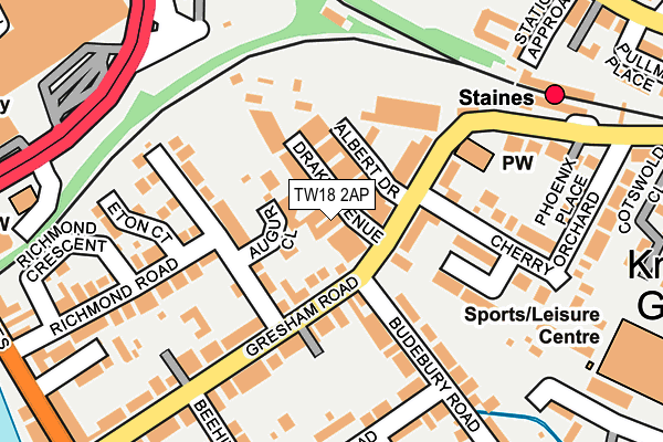
TW18 2AP lies on Drake Avenue in Staines-upon-thames. TW18 2AP is located in the Staines electoral ward, within the local authority district of Spelthorne and the English Parliamentary constituency of Spelthorne. The Sub Integrated Care Board (ICB) Location is NHS Surrey Heartlands ICB - 92A and the police force is Surrey. This postcode has been in use since January 1980.


GetTheData
Source: OS OpenMap – Local (Ordnance Survey)
Source: OS VectorMap District (Ordnance Survey)
Licence: Open Government Licence (requires attribution)
| Easting | 503955 |
| Northing | 171331 |
| Latitude | 51.431456 |
| Longitude | -0.505983 |
GetTheData
Source: Open Postcode Geo
Licence: Open Government Licence
| Street | Drake Avenue |
| Town/City | Staines-upon-thames |
| Country | England |
| Postcode District | TW18 |
➜ See where TW18 is on a map ➜ Where is Staines-upon-Thames? | |
GetTheData
Source: Land Registry Price Paid Data
Licence: Open Government Licence
Elevation or altitude of TW18 2AP as distance above sea level:
| Metres | Feet | |
|---|---|---|
| Elevation | 20m | 66ft |
Elevation is measured from the approximate centre of the postcode, to the nearest point on an OS contour line from OS Terrain 50, which has contour spacing of ten vertical metres.
➜ How high above sea level am I? Find the elevation of your current position using your device's GPS.
GetTheData
Source: Open Postcode Elevation
Licence: Open Government Licence
| Ward | Staines |
| Constituency | Spelthorne |
GetTheData
Source: ONS Postcode Database
Licence: Open Government Licence
| Staines Railway Station (Station Approach) | Staines | 235m |
| Staines Railway Station (Kingston Road) | Staines | 297m |
| Staines Railway Station (Kingston Road) | Staines | 334m |
| London Road (Kingston Road) | Staines | 364m |
| London Road (Kingston Road) | Staines | 383m |
| Staines Station | 0.2km |
| Ashford (Surrey) Station | 2.7km |
| Egham Station | 2.8km |
GetTheData
Source: NaPTAN
Licence: Open Government Licence
GetTheData
Source: ONS Postcode Database
Licence: Open Government Licence


➜ Get more ratings from the Food Standards Agency
GetTheData
Source: Food Standards Agency
Licence: FSA terms & conditions
| Last Collection | |||
|---|---|---|---|
| Location | Mon-Fri | Sat | Distance |
| Railway Station, Gresham Road | 17:30 | 11:45 | 80m |
| 13 Laleham Road | 17:30 | 11:00 | 324m |
| Kingston Road | 18:30 | 11:00 | 325m |
GetTheData
Source: Dracos
Licence: Creative Commons Attribution-ShareAlike
| Risk of TW18 2AP flooding from rivers and sea | Low |
| ➜ TW18 2AP flood map | |
GetTheData
Source: Open Flood Risk by Postcode
Licence: Open Government Licence
The below table lists the International Territorial Level (ITL) codes (formerly Nomenclature of Territorial Units for Statistics (NUTS) codes) and Local Administrative Units (LAU) codes for TW18 2AP:
| ITL 1 Code | Name |
|---|---|
| TLJ | South East (England) |
| ITL 2 Code | Name |
| TLJ2 | Surrey, East and West Sussex |
| ITL 3 Code | Name |
| TLJ25 | West Surrey |
| LAU 1 Code | Name |
| E07000213 | Spelthorne |
GetTheData
Source: ONS Postcode Directory
Licence: Open Government Licence
The below table lists the Census Output Area (OA), Lower Layer Super Output Area (LSOA), and Middle Layer Super Output Area (MSOA) for TW18 2AP:
| Code | Name | |
|---|---|---|
| OA | E00156730 | |
| LSOA | E01030736 | Spelthorne 004C |
| MSOA | E02006406 | Spelthorne 004 |
GetTheData
Source: ONS Postcode Directory
Licence: Open Government Licence
| TW18 2DL | Augur Close | 35m |
| TW18 2AW | Drake Avenue | 52m |
| TW18 2AN | Gresham Road | 63m |
| TW18 2FA | Gresham Road | 111m |
| TW18 2DG | Cherry Orchard | 113m |
| TW18 2FB | Gresham Road | 126m |
| TW18 2BY | Gresham Road | 128m |
| TW18 2BD | Gresham Road | 139m |
| TW18 2DJ | Murdoch Close | 141m |
| TW18 2BW | Richmond Road | 152m |
GetTheData
Source: Open Postcode Geo; Land Registry Price Paid Data
Licence: Open Government Licence