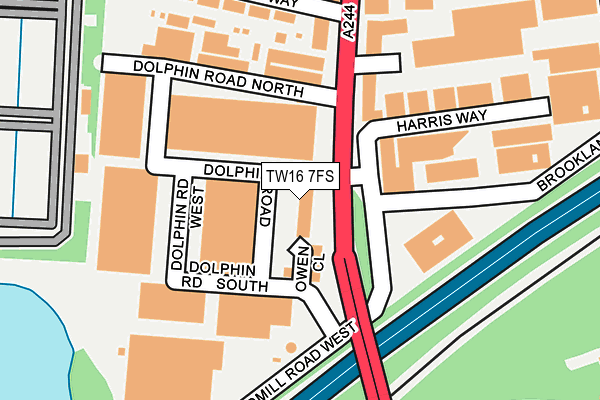
TW16 7FS is located in the Laleham and Shepperton Green electoral ward, within the local authority district of Spelthorne and the English Parliamentary constituency of Spelthorne. The Sub Integrated Care Board (ICB) Location is NHS Surrey Heartlands ICB - 92A and the police force is Surrey. This postcode has been in use since July 2017.


GetTheData
Source: OS OpenMap – Local (Ordnance Survey)
Source: OS VectorMap District (Ordnance Survey)
Licence: Open Government Licence (requires attribution)
| Easting | 509171 |
| Northing | 169635 |
| Latitude | 51.415232 |
| Longitude | -0.431501 |
GetTheData
Source: Open Postcode Geo
Licence: Open Government Licence
| Country | England |
| Postcode District | TW16 |
➜ See where TW16 is on a map ➜ Where is Sunbury-on-Thames? | |
GetTheData
Source: Land Registry Price Paid Data
Licence: Open Government Licence
| Ward | Laleham And Shepperton Green |
| Constituency | Spelthorne |
GetTheData
Source: ONS Postcode Database
Licence: Open Government Licence
| Peregrine Road (Nursery Road) | Sunbury | 323m |
| Peregrine Road (Nursery Road) | Sunbury | 430m |
| Upper Halliford Railway Station (Upper Halliford Road) | Upper Halliford | 474m |
| Tesco (Escot Way) | Sunbury | 494m |
| Windmill Road (Staines Road West) | Sunbury | 600m |
| Upper Halliford Station | 0.2km |
| Sunbury Station | 1km |
| Kempton Park Station | 1.6km |
GetTheData
Source: NaPTAN
Licence: Open Government Licence
| Percentage of properties with Next Generation Access | 100.0% |
| Percentage of properties with Superfast Broadband | 100.0% |
| Percentage of properties with Ultrafast Broadband | 100.0% |
| Percentage of properties with Full Fibre Broadband | 100.0% |
Superfast Broadband is between 30Mbps and 300Mbps
Ultrafast Broadband is > 300Mbps
Ofcom does not currently provide download speed data for TW16 7FS. This is because there are less than four broadband connections in this postcode.
Ofcom does not currently provide upload speed data for TW16 7FS. This is because there are less than four broadband connections in this postcode.
| Percentage of properties unable to receive 2Mbps | 0.0% |
| Percentage of properties unable to receive 5Mbps | 0.0% |
| Percentage of properties unable to receive 10Mbps | 0.0% |
| Percentage of properties unable to receive 30Mbps | 0.0% |
GetTheData
Source: Ofcom
Licence: Ofcom Terms of Use (requires attribution)
GetTheData
Source: ONS Postcode Database
Licence: Open Government Licence


➜ Get more ratings from the Food Standards Agency
GetTheData
Source: Food Standards Agency
Licence: FSA terms & conditions
| Last Collection | |||
|---|---|---|---|
| Location | Mon-Fri | Sat | Distance |
| Brooklands Close | 288m | ||
| Cedar Way | 18:30 | 11:45 | 466m |
| Post Office, 60 Nursery Road | 17:00 | 11:45 | 659m |
GetTheData
Source: Dracos
Licence: Creative Commons Attribution-ShareAlike
The below table lists the International Territorial Level (ITL) codes (formerly Nomenclature of Territorial Units for Statistics (NUTS) codes) and Local Administrative Units (LAU) codes for TW16 7FS:
| ITL 1 Code | Name |
|---|---|
| TLJ | South East (England) |
| ITL 2 Code | Name |
| TLJ2 | Surrey, East and West Sussex |
| ITL 3 Code | Name |
| TLJ25 | West Surrey |
| LAU 1 Code | Name |
| E07000213 | Spelthorne |
GetTheData
Source: ONS Postcode Directory
Licence: Open Government Licence
The below table lists the Census Output Area (OA), Lower Layer Super Output Area (LSOA), and Middle Layer Super Output Area (MSOA) for TW16 7FS:
| Code | Name | |
|---|---|---|
| OA | E00167802 | |
| LSOA | E01030725 | Spelthorne 006E |
| MSOA | E02006408 | Spelthorne 006 |
GetTheData
Source: ONS Postcode Directory
Licence: Open Government Licence
| TW16 7EF | Windmill Road | 125m |
| TW16 7HB | Windmill Road | 130m |
| TW16 7EL | Harris Way | 162m |
| TW16 7HJ | Lincoln Way | 216m |
| TW16 7HP | International Way | 253m |
| TW16 7DY | Windmill Business Village | 274m |
| TW16 7FD | Brooklands Close | 302m |
| TW16 7HL | Millfield | 308m |
| TW17 8RL | Kelly Close | 331m |
| TW16 7HR | International Way | 336m |
GetTheData
Source: Open Postcode Geo; Land Registry Price Paid Data
Licence: Open Government Licence