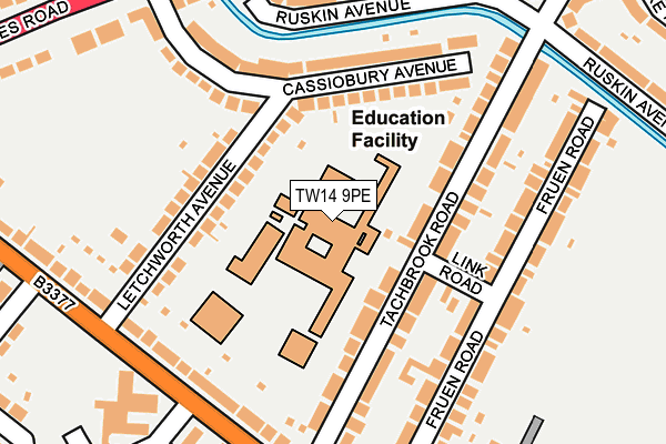
TW14 9PE is located in the Feltham North electoral ward, within the London borough of Hounslow and the English Parliamentary constituency of Feltham and Heston. The Sub Integrated Care Board (ICB) Location is NHS North West London ICB - W2U3Z and the police force is Metropolitan Police. This postcode has been in use since June 2017.


GetTheData
Source: OS OpenMap – Local (Ordnance Survey)
Source: OS VectorMap District (Ordnance Survey)
Licence: Open Government Licence (requires attribution)
| Easting | 509821 |
| Northing | 173842 |
| Latitude | 51.452919 |
| Longitude | -0.420854 |
GetTheData
Source: Open Postcode Geo
Licence: Open Government Licence
| Country | England |
| Postcode District | TW14 |
➜ See where TW14 is on a map ➜ Where is Feltham? | |
GetTheData
Source: Land Registry Price Paid Data
Licence: Open Government Licence
| Ward | Feltham North |
| Constituency | Feltham And Heston |
GetTheData
Source: ONS Postcode Database
Licence: Open Government Licence
| Letchworth Avenue (Bedfont Lane) | East Bedfont | 204m |
| Tachbrook Road (Bedfont Lane) | East Bedfont | 213m |
| Tachbrook Road (Bedfont Lane) | East Bedfont | 243m |
| Cassiobury Avenue (Staines Road) | East Bedfont | 261m |
| Cassiobury Avenue (Staines Road) | East Bedfont | 292m |
| Feltham Station | 0.9km |
| Heathrow Terminal 4 Station | 1.8km |
| Heathrow Terminal 4 (Rail-Air) | 1.9km |
GetTheData
Source: NaPTAN
Licence: Open Government Licence
GetTheData
Source: ONS Postcode Database
Licence: Open Government Licence


➜ Get more ratings from the Food Standards Agency
GetTheData
Source: Food Standards Agency
Licence: FSA terms & conditions
| Last Collection | |||
|---|---|---|---|
| Location | Mon-Fri | Sat | Distance |
| Hounslow / Staines Roads | 18:30 | 11:30 | 532m |
| Westmacott Dr. / Grasmere Cl. | 17:00 | 11:30 | 692m |
| 158 The Centre | 18:30 | 11:30 | 989m |
GetTheData
Source: Dracos
Licence: Creative Commons Attribution-ShareAlike
The below table lists the International Territorial Level (ITL) codes (formerly Nomenclature of Territorial Units for Statistics (NUTS) codes) and Local Administrative Units (LAU) codes for TW14 9PE:
| ITL 1 Code | Name |
|---|---|
| TLI | London |
| ITL 2 Code | Name |
| TLI7 | Outer London - West and North West |
| ITL 3 Code | Name |
| TLI75 | Hounslow and Richmond upon Thames |
| LAU 1 Code | Name |
| E09000018 | Hounslow |
GetTheData
Source: ONS Postcode Directory
Licence: Open Government Licence
The below table lists the Census Output Area (OA), Lower Layer Super Output Area (LSOA), and Middle Layer Super Output Area (MSOA) for TW14 9PE:
| Code | Name | |
|---|---|---|
| OA | E00012900 | |
| LSOA | E01002590 | Hounslow 022C |
| MSOA | E02000547 | Hounslow 022 |
GetTheData
Source: ONS Postcode Directory
Licence: Open Government Licence
| TW14 9PD | Tachbrook Road | 75m |
| TW14 9RY | Letchworth Avenue | 97m |
| TW14 9NX | Tachbrook Road | 100m |
| TW14 9JF | Cassiobury Avenue | 109m |
| TW14 9RZ | Letchworth Avenue | 141m |
| TW14 9JE | Cassiobury Avenue | 143m |
| TW14 9NT | Fruen Road | 176m |
| TW14 9NS | Fruen Road | 177m |
| TW14 9NR | Fruen Road | 179m |
| TW14 9NU | Bedfont Lane | 189m |
GetTheData
Source: Open Postcode Geo; Land Registry Price Paid Data
Licence: Open Government Licence