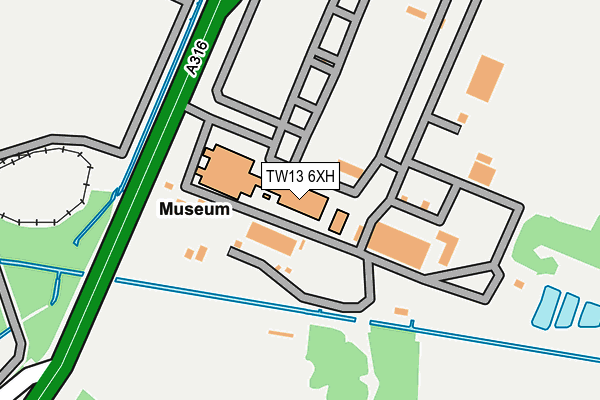
TW13 6XH is located in the Hanworth Village electoral ward, within the London borough of Hounslow and the English Parliamentary constituency of Feltham and Heston. The Sub Integrated Care Board (ICB) Location is NHS North West London ICB - W2U3Z and the police force is Metropolitan Police. This postcode has been in use since January 1980.


GetTheData
Source: OS OpenMap – Local (Ordnance Survey)
Source: OS VectorMap District (Ordnance Survey)
Licence: Open Government Licence (requires attribution)
| Easting | 511082 |
| Northing | 170826 |
| Latitude | 51.425566 |
| Longitude | -0.403680 |
GetTheData
Source: Open Postcode Geo
Licence: Open Government Licence
| Country | England |
| Postcode District | TW13 |
➜ See where TW13 is on a map ➜ Where is London? | |
GetTheData
Source: Land Registry Price Paid Data
Licence: Open Government Licence
Elevation or altitude of TW13 6XH as distance above sea level:
| Metres | Feet | |
|---|---|---|
| Elevation | 20m | 66ft |
Elevation is measured from the approximate centre of the postcode, to the nearest point on an OS contour line from OS Terrain 50, which has contour spacing of ten vertical metres.
➜ How high above sea level am I? Find the elevation of your current position using your device's GPS.
GetTheData
Source: Open Postcode Elevation
Licence: Open Government Licence
| Ward | Hanworth Village |
| Constituency | Feltham And Heston |
GetTheData
Source: ONS Postcode Database
Licence: Open Government Licence
| Nallhead Road | Hanworth | 589m |
| Dickenson Road (Tw13) (Nallhead Road) | Hanworth | 611m |
| Park Road (A316) | Sunbury | 613m |
| Sunbury Way | Hanworth | 631m |
| Nallhead Road | Hanworth | 632m |
| Kempton Park Station | 0.7km |
| Sunbury Station | 1.3km |
| Upper Halliford Station | 2.3km |
GetTheData
Source: NaPTAN
Licence: Open Government Licence
GetTheData
Source: ONS Postcode Database
Licence: Open Government Licence


➜ Get more ratings from the Food Standards Agency
GetTheData
Source: Food Standards Agency
Licence: FSA terms & conditions
| Last Collection | |||
|---|---|---|---|
| Location | Mon-Fri | Sat | Distance |
| Raleigh Way / Feltham Hill Road | 18:30 | 11:45 | 576m |
| Beechwood Avenue | 18:30 | 12:00 | 630m |
| Main Street / Lebanon Avenue | 17:15 | 11:45 | 847m |
GetTheData
Source: Dracos
Licence: Creative Commons Attribution-ShareAlike
The below table lists the International Territorial Level (ITL) codes (formerly Nomenclature of Territorial Units for Statistics (NUTS) codes) and Local Administrative Units (LAU) codes for TW13 6XH:
| ITL 1 Code | Name |
|---|---|
| TLI | London |
| ITL 2 Code | Name |
| TLI7 | Outer London - West and North West |
| ITL 3 Code | Name |
| TLI75 | Hounslow and Richmond upon Thames |
| LAU 1 Code | Name |
| E09000018 | Hounslow |
GetTheData
Source: ONS Postcode Directory
Licence: Open Government Licence
The below table lists the Census Output Area (OA), Lower Layer Super Output Area (LSOA), and Middle Layer Super Output Area (MSOA) for TW13 6XH:
| Code | Name | |
|---|---|---|
| OA | E00012962 | |
| LSOA | E01002610 | Hounslow 028C |
| MSOA | E02000553 | Hounslow 028 |
GetTheData
Source: ONS Postcode Directory
Licence: Open Government Licence
| TW13 6SW | Dickenson Road | 543m |
| TW13 6SS | Nallhead Road | 588m |
| TW16 7RS | Ashridge Way | 612m |
| TW16 7SB | Ashridge Way | 640m |
| TW13 6SP | Church Road | 673m |
| TW13 7NX | Raleigh Way | 678m |
| TW13 6ST | Main Street | 678m |
| TW13 6XJ | Sunbury Way | 679m |
| TW13 7NU | Queens Avenue | 683m |
| TW13 7NY | Raleigh Way | 687m |
GetTheData
Source: Open Postcode Geo; Land Registry Price Paid Data
Licence: Open Government Licence