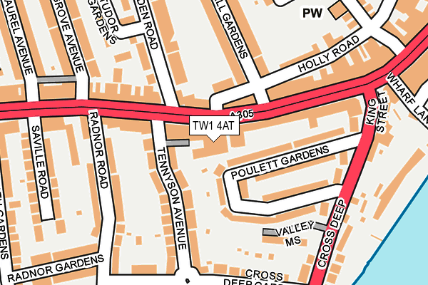
TW1 4AT is located in the South Twickenham electoral ward, within the London borough of Richmond upon Thames and the English Parliamentary constituency of Twickenham. The Sub Integrated Care Board (ICB) Location is NHS South West London ICB - 36L and the police force is Metropolitan Police. This postcode has been in use since January 1980.


GetTheData
Source: OS OpenMap – Local (Ordnance Survey)
Source: OS VectorMap District (Ordnance Survey)
Licence: Open Government Licence (requires attribution)
| Easting | 515947 |
| Northing | 173080 |
| Latitude | 51.444851 |
| Longitude | -0.333000 |
GetTheData
Source: Open Postcode Geo
Licence: Open Government Licence
| Country | England |
| Postcode District | TW1 |
➜ See where TW1 is on a map ➜ Where is Twickenham? | |
GetTheData
Source: Land Registry Price Paid Data
Licence: Open Government Licence
Elevation or altitude of TW1 4AT as distance above sea level:
| Metres | Feet | |
|---|---|---|
| Elevation | 10m | 33ft |
Elevation is measured from the approximate centre of the postcode, to the nearest point on an OS contour line from OS Terrain 50, which has contour spacing of ten vertical metres.
➜ How high above sea level am I? Find the elevation of your current position using your device's GPS.
GetTheData
Source: Open Postcode Elevation
Licence: Open Government Licence
| Ward | South Twickenham |
| Constituency | Twickenham |
GetTheData
Source: ONS Postcode Database
Licence: Open Government Licence
| Heath Road Twickenham | Twickenham | 150m |
| Heath Road Twickenham (Heath Road) | Twickenham | 181m |
| Heath Road Twickenham | Twickenham | 184m |
| Poulett Gardens | Twickenham | 198m |
| Heath Road Grove Avenue (Heath Road) | Twickenham | 212m |
| Twickenham Station | 0.6km |
| Strawberry Hill Station | 0.8km |
| St Margarets (London) Station | 1.5km |
GetTheData
Source: NaPTAN
Licence: Open Government Licence
GetTheData
Source: ONS Postcode Database
Licence: Open Government Licence


➜ Get more ratings from the Food Standards Agency
GetTheData
Source: Food Standards Agency
Licence: FSA terms & conditions
| Last Collection | |||
|---|---|---|---|
| Location | Mon-Fri | Sat | Distance |
| Clifden Road | 18:30 | 11:30 | 86m |
| Tw1 O/S 48 King Street | 19:00 | 11:30 | 238m |
| Post Office, 48 King Street | 19:00 | 11:30 | 244m |
GetTheData
Source: Dracos
Licence: Creative Commons Attribution-ShareAlike
The below table lists the International Territorial Level (ITL) codes (formerly Nomenclature of Territorial Units for Statistics (NUTS) codes) and Local Administrative Units (LAU) codes for TW1 4AT:
| ITL 1 Code | Name |
|---|---|
| TLI | London |
| ITL 2 Code | Name |
| TLI7 | Outer London - West and North West |
| ITL 3 Code | Name |
| TLI75 | Hounslow and Richmond upon Thames |
| LAU 1 Code | Name |
| E09000027 | Richmond upon Thames |
GetTheData
Source: ONS Postcode Directory
Licence: Open Government Licence
The below table lists the Census Output Area (OA), Lower Layer Super Output Area (LSOA), and Middle Layer Super Output Area (MSOA) for TW1 4AT:
| Code | Name | |
|---|---|---|
| OA | E00019529 | |
| LSOA | E01003882 | Richmond upon Thames 014A |
| MSOA | E02000797 | Richmond upon Thames 014 |
GetTheData
Source: ONS Postcode Directory
Licence: Open Government Licence
| TW1 4BX | Heath Road | 65m |
| TW1 4AW | Heath Road | 66m |
| TW1 4QR | Poulett Gardens | 67m |
| TW1 4HQ | Holly Road | 82m |
| TW1 4AX | Heath Road | 90m |
| TW1 4QX | Tennyson Avenue | 92m |
| TW1 4DG | Heath Road | 103m |
| TW1 4QS | Poulett Gardens | 109m |
| TW1 4QY | Tennyson Avenue | 113m |
| TW1 4DH | Heath Road | 123m |
GetTheData
Source: Open Postcode Geo; Land Registry Price Paid Data
Licence: Open Government Licence