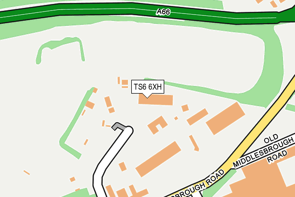
TS6 6XH lies on Dormor Way in South Bank, Middlesbrough. TS6 6XH is located in the South Bank electoral ward, within the unitary authority of Redcar and Cleveland and the English Parliamentary constituency of Redcar. The Sub Integrated Care Board (ICB) Location is NHS North East and North Cumbria ICB - 16C and the police force is Cleveland. This postcode has been in use since July 1986.


GetTheData
Source: OS OpenMap – Local (Ordnance Survey)
Source: OS VectorMap District (Ordnance Survey)
Licence: Open Government Licence (requires attribution)
| Easting | 452535 |
| Northing | 520531 |
| Latitude | 54.577282 |
| Longitude | -1.188803 |
GetTheData
Source: Open Postcode Geo
Licence: Open Government Licence
| Street | Dormor Way |
| Locality | South Bank |
| Town/City | Middlesbrough |
| Country | England |
| Postcode District | TS6 |
➜ See where TS6 is on a map ➜ Where is Middlesbrough? | |
GetTheData
Source: Land Registry Price Paid Data
Licence: Open Government Licence
Elevation or altitude of TS6 6XH as distance above sea level:
| Metres | Feet | |
|---|---|---|
| Elevation | 10m | 33ft |
Elevation is measured from the approximate centre of the postcode, to the nearest point on an OS contour line from OS Terrain 50, which has contour spacing of ten vertical metres.
➜ How high above sea level am I? Find the elevation of your current position using your device's GPS.
GetTheData
Source: Open Postcode Elevation
Licence: Open Government Licence
| Ward | South Bank |
| Constituency | Redcar |
GetTheData
Source: ONS Postcode Database
Licence: Open Government Licence
| Cargo Fleet Business Centre (Middlesbrough Road) | Skippers Lane Ind Est | 233m |
| Cargo Fleet Business Centre (Middlesbrough Road) | Skippers Lane Ind Est | 252m |
| Imperial Food Park (Tilbury Road) | Skippers Lane Ind Est | 482m |
| Queensway (South Bank Road) | Cargo Fleet | 550m |
| Station Road (Middlesbrough Road) | South Bank | 572m |
| South Bank Station | 1.1km |
| Middlesbrough Station | 3km |
| James Cook University Hospital Station | 3.1km |
GetTheData
Source: NaPTAN
Licence: Open Government Licence
GetTheData
Source: ONS Postcode Database
Licence: Open Government Licence


➜ Get more ratings from the Food Standards Agency
GetTheData
Source: Food Standards Agency
Licence: FSA terms & conditions
| Last Collection | |||
|---|---|---|---|
| Location | Mon-Fri | Sat | Distance |
| North Ormesby Post Office | 18:00 | 12:15 | 1,758m |
| Birchington Avenue P.o. | 17:00 | 12:15 | 1,897m |
| Norfolk Place Post Office | 17:00 | 11:45 | 2,081m |
GetTheData
Source: Dracos
Licence: Creative Commons Attribution-ShareAlike
The below table lists the International Territorial Level (ITL) codes (formerly Nomenclature of Territorial Units for Statistics (NUTS) codes) and Local Administrative Units (LAU) codes for TS6 6XH:
| ITL 1 Code | Name |
|---|---|
| TLC | North East (England) |
| ITL 2 Code | Name |
| TLC1 | Tees Valley and Durham |
| ITL 3 Code | Name |
| TLC12 | South Teesside |
| LAU 1 Code | Name |
| E06000003 | Redcar and Cleveland |
GetTheData
Source: ONS Postcode Directory
Licence: Open Government Licence
The below table lists the Census Output Area (OA), Lower Layer Super Output Area (LSOA), and Middle Layer Super Output Area (MSOA) for TS6 6XH:
| Code | Name | |
|---|---|---|
| OA | E00174123 | |
| LSOA | E01033470 | Redcar and Cleveland 022G |
| MSOA | E02006910 | Redcar and Cleveland 022 |
GetTheData
Source: ONS Postcode Directory
Licence: Open Government Licence
| TS6 6HX | Owens Road | 396m |
| TS6 6HE | Owens Road | 411m |
| TS3 8BL | Telford Road | 496m |
| TS6 6EX | Salisbury Terrace | 523m |
| TS6 6EB | Tyne Street | 586m |
| TS6 6PS | Newcomen Road | 639m |
| TS6 6EH | Upper Princess Street | 649m |
| TS6 6HH | South Terrace | 660m |
| TS6 6LZ | Middlesbrough Road | 664m |
| TS6 6EF | Upper Oxford Street | 670m |
GetTheData
Source: Open Postcode Geo; Land Registry Price Paid Data
Licence: Open Government Licence