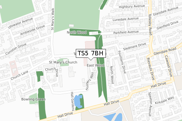
TS5 7BH is located in the Acklam electoral ward, within the unitary authority of Middlesbrough and the English Parliamentary constituency of Middlesbrough. The Sub Integrated Care Board (ICB) Location is NHS North East and North Cumbria ICB - 16C and the police force is Cleveland. This postcode has been in use since March 2018.


GetTheData
Source: OS Open Zoomstack (Ordnance Survey)
Licence: Open Government Licence (requires attribution)
Attribution: Contains OS data © Crown copyright and database right 2025
Source: Open Postcode Geo
Licence: Open Government Licence (requires attribution)
Attribution: Contains OS data © Crown copyright and database right 2025; Contains Royal Mail data © Royal Mail copyright and database right 2025; Source: Office for National Statistics licensed under the Open Government Licence v.3.0
| Easting | 448828 |
| Northing | 517051 |
| Latitude | 54.546381 |
| Longitude | -1.246721 |
GetTheData
Source: Open Postcode Geo
Licence: Open Government Licence
| Country | England |
| Postcode District | TS5 |
➜ See where TS5 is on a map ➜ Where is Middlesbrough? | |
GetTheData
Source: Land Registry Price Paid Data
Licence: Open Government Licence
| Ward | Acklam |
| Constituency | Middlesbrough |
GetTheData
Source: ONS Postcode Database
Licence: Open Government Licence
| School Base (Hall Drive) | Acklam | 247m |
| School Base (Hall Drive) | Acklam | 269m |
| Rievaulx Drive | Acklam | 344m |
| Rievaulx Drive | Acklam | 374m |
| Glaisdale Avenue (Tollesby Road) | Acklam | 421m |
| James Cook University Hospital Station | 2.5km |
| Marton Station | 3.1km |
| Middlesbrough Station | 3.7km |
GetTheData
Source: NaPTAN
Licence: Open Government Licence
GetTheData
Source: ONS Postcode Database
Licence: Open Government Licence


➜ Get more ratings from the Food Standards Agency
GetTheData
Source: Food Standards Agency
Licence: FSA terms & conditions
| Last Collection | |||
|---|---|---|---|
| Location | Mon-Fri | Sat | Distance |
| St Marys Walk | 17:45 | 12:45 | 254m |
| Tollesby Post Office | 17:15 | 11:30 | 445m |
| Acklam Road Post Office | 18:00 | 12:00 | 745m |
GetTheData
Source: Dracos
Licence: Creative Commons Attribution-ShareAlike
The below table lists the International Territorial Level (ITL) codes (formerly Nomenclature of Territorial Units for Statistics (NUTS) codes) and Local Administrative Units (LAU) codes for TS5 7BH:
| ITL 1 Code | Name |
|---|---|
| TLC | North East (England) |
| ITL 2 Code | Name |
| TLC1 | Tees Valley and Durham |
| ITL 3 Code | Name |
| TLC12 | South Teesside |
| LAU 1 Code | Name |
| E06000002 | Middlesbrough |
GetTheData
Source: ONS Postcode Directory
Licence: Open Government Licence
The below table lists the Census Output Area (OA), Lower Layer Super Output Area (LSOA), and Middle Layer Super Output Area (MSOA) for TS5 7BH:
| Code | Name | |
|---|---|---|
| OA | E00060573 | |
| LSOA | E01012009 | Middlesbrough 012C |
| MSOA | E02002507 | Middlesbrough 012 |
GetTheData
Source: ONS Postcode Directory
Licence: Open Government Licence
| TS5 7DT | Hustlers Way | 95m |
| TS5 7LL | North Wood | 134m |
| TS5 7LH | Fountains Drive | 139m |
| TS5 7LN | North Wood | 147m |
| TS5 7LW | Fountains Drive | 178m |
| TS5 7LJ | Fountains Drive | 179m |
| TS5 7LD | Parkfield Avenue | 207m |
| TS5 7LP | Helmsley Close | 217m |
| TS5 7LT | Levisham Close | 239m |
| TS5 7LX | Fountains Drive | 245m |
GetTheData
Source: Open Postcode Geo; Land Registry Price Paid Data
Licence: Open Government Licence