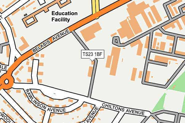
TS23 1BF is located in the Billingham South electoral ward, within the unitary authority of Stockton-on-Tees and the English Parliamentary constituency of Stockton North. The Sub Integrated Care Board (ICB) Location is NHS North East and North Cumbria ICB - 16C and the police force is Cleveland. This postcode has been in use since November 2015.


GetTheData
Source: OS OpenMap – Local (Ordnance Survey)
Source: OS VectorMap District (Ordnance Survey)
Licence: Open Government Licence (requires attribution)
| Easting | 446372 |
| Northing | 522433 |
| Latitude | 54.594974 |
| Longitude | -1.283837 |
GetTheData
Source: Open Postcode Geo
Licence: Open Government Licence
| Country | England |
| Postcode District | TS23 |
➜ See where TS23 is on a map ➜ Where is Billingham? | |
GetTheData
Source: Land Registry Price Paid Data
Licence: Open Government Licence
Elevation or altitude of TS23 1BF as distance above sea level:
| Metres | Feet | |
|---|---|---|
| Elevation | 20m | 66ft |
Elevation is measured from the approximate centre of the postcode, to the nearest point on an OS contour line from OS Terrain 50, which has contour spacing of ten vertical metres.
➜ How high above sea level am I? Find the elevation of your current position using your device's GPS.
GetTheData
Source: Open Postcode Elevation
Licence: Open Government Licence
| Ward | Billingham South |
| Constituency | Stockton North |
GetTheData
Source: ONS Postcode Database
Licence: Open Government Licence
| Ici Synthonia Club (Belasis Avenue) | Billingham | 145m |
| Ici Synthonia Club (Cowpen Lane) | Billingham | 237m |
| Stores (Belasis Avenue) | Billingham | 329m |
| Stores (Belasis Avenue) | Billingham | 337m |
| Wharfdale Avenue Library (Bedale Avenue) | Billingham | 377m |
| Billingham Station | 1.2km |
| Stockton Station | 3.6km |
| Middlesbrough Station | 3.6km |
GetTheData
Source: NaPTAN
Licence: Open Government Licence
GetTheData
Source: ONS Postcode Database
Licence: Open Government Licence


➜ Get more ratings from the Food Standards Agency
GetTheData
Source: Food Standards Agency
Licence: FSA terms & conditions
| Last Collection | |||
|---|---|---|---|
| Location | Mon-Fri | Sat | Distance |
| Marsh House Avenue | 17:30 | 12:30 | 1,554m |
| Roseberry Road | 17:30 | 12:30 | 1,766m |
| Albany Road | 17:30 | 11:00 | 1,809m |
GetTheData
Source: Dracos
Licence: Creative Commons Attribution-ShareAlike
The below table lists the International Territorial Level (ITL) codes (formerly Nomenclature of Territorial Units for Statistics (NUTS) codes) and Local Administrative Units (LAU) codes for TS23 1BF:
| ITL 1 Code | Name |
|---|---|
| TLC | North East (England) |
| ITL 2 Code | Name |
| TLC1 | Tees Valley and Durham |
| ITL 3 Code | Name |
| TLC11 | Hartlepool and Stockton-on-Tees |
| LAU 1 Code | Name |
| E06000004 | Stockton-on-Tees |
GetTheData
Source: ONS Postcode Directory
Licence: Open Government Licence
The below table lists the Census Output Area (OA), Lower Layer Super Output Area (LSOA), and Middle Layer Super Output Area (MSOA) for TS23 1BF:
| Code | Name | |
|---|---|---|
| OA | E00061920 | |
| LSOA | E01012279 | Stockton-on-Tees 004B |
| MSOA | E02002538 | Stockton-on-Tees 004 |
GetTheData
Source: ONS Postcode Directory
Licence: Open Government Licence
| TS23 1JE | Chiltons Avenue | 121m |
| TS23 1JG | Rawlinson Avenue | 171m |
| TS23 1JA | Tibbersley Avenue | 183m |
| TS23 1FD | Monksfield | 195m |
| TS23 1JQ | Grange Avenue | 224m |
| TS23 1FG | Monksfield | 225m |
| TS23 1FE | Monksfield | 236m |
| TS23 1FF | Monksfield | 240m |
| TS23 1JF | Chiltons Avenue | 242m |
| TS23 1JP | Tibbersley Avenue | 259m |
GetTheData
Source: Open Postcode Geo; Land Registry Price Paid Data
Licence: Open Government Licence