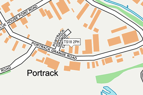
TS18 2PH is located in the Stockton Town Centre electoral ward, within the unitary authority of Stockton-on-Tees and the English Parliamentary constituency of Stockton North. The Sub Integrated Care Board (ICB) Location is NHS North East and North Cumbria ICB - 16C and the police force is Cleveland. This postcode has been in use since January 1980.


GetTheData
Source: OS OpenMap – Local (Ordnance Survey)
Source: OS VectorMap District (Ordnance Survey)
Licence: Open Government Licence (requires attribution)
| Easting | 446617 |
| Northing | 519791 |
| Latitude | 54.571210 |
| Longitude | -1.280464 |
GetTheData
Source: Open Postcode Geo
Licence: Open Government Licence
| Country | England |
| Postcode District | TS18 |
➜ See where TS18 is on a map ➜ Where is Stockton-on-Tees? | |
GetTheData
Source: Land Registry Price Paid Data
Licence: Open Government Licence
Elevation or altitude of TS18 2PH as distance above sea level:
| Metres | Feet | |
|---|---|---|
| Elevation | 10m | 33ft |
Elevation is measured from the approximate centre of the postcode, to the nearest point on an OS contour line from OS Terrain 50, which has contour spacing of ten vertical metres.
➜ How high above sea level am I? Find the elevation of your current position using your device's GPS.
GetTheData
Source: Open Postcode Elevation
Licence: Open Government Licence
| Ward | Stockton Town Centre |
| Constituency | Stockton North |
GetTheData
Source: ONS Postcode Database
Licence: Open Government Licence
| Asda Stores (Portrack Lane) | Portrack | 385m |
| Asda Stores (Portrack Lane) | Portrack | 393m |
| Asda (Marston Road) | Portrack | 411m |
| Teesway (Haverton Hill Road) | Portrack | 510m |
| Teesway (Haverton Hill Road) | Portrack | 603m |
| Thornaby Station | 1.9km |
| Stockton Station | 2.5km |
| Middlesbrough Station | 3.1km |
GetTheData
Source: NaPTAN
Licence: Open Government Licence
| Median download speed | 4.7Mbps |
| Average download speed | 4.7Mbps |
| Maximum download speed | 5.69Mbps |
| Median upload speed | 0.9Mbps |
| Average upload speed | 0.8Mbps |
| Maximum upload speed | 1.11Mbps |
GetTheData
Source: Ofcom
Licence: Ofcom Terms of Use (requires attribution)
Estimated total energy consumption in TS18 2PH by fuel type, 2015.
| Consumption (kWh) | 235,904 |
|---|---|
| Meter count | 11 |
| Mean (kWh/meter) | 21,446 |
| Median (kWh/meter) | 17,642 |
GetTheData
Source: Postcode level gas estimates: 2015 (experimental)
Source: Postcode level electricity estimates: 2015 (experimental)
Licence: Open Government Licence
GetTheData
Source: ONS Postcode Database
Licence: Open Government Licence


➜ Get more ratings from the Food Standards Agency
GetTheData
Source: Food Standards Agency
Licence: FSA terms & conditions
| Last Collection | |||
|---|---|---|---|
| Location | Mon-Fri | Sat | Distance |
| Teesside Park | 17:00 | 13:00 | 1,625m |
| Harvard Avenue | 17:30 | 11:00 | 1,638m |
| Acklam P.o | 17:30 | 12:45 | 1,909m |
GetTheData
Source: Dracos
Licence: Creative Commons Attribution-ShareAlike
The below table lists the International Territorial Level (ITL) codes (formerly Nomenclature of Territorial Units for Statistics (NUTS) codes) and Local Administrative Units (LAU) codes for TS18 2PH:
| ITL 1 Code | Name |
|---|---|
| TLC | North East (England) |
| ITL 2 Code | Name |
| TLC1 | Tees Valley and Durham |
| ITL 3 Code | Name |
| TLC11 | Hartlepool and Stockton-on-Tees |
| LAU 1 Code | Name |
| E06000004 | Stockton-on-Tees |
GetTheData
Source: ONS Postcode Directory
Licence: Open Government Licence
The below table lists the Census Output Area (OA), Lower Layer Super Output Area (LSOA), and Middle Layer Super Output Area (MSOA) for TS18 2PH:
| Code | Name | |
|---|---|---|
| OA | E00061857 | |
| LSOA | E01012266 | Stockton-on-Tees 014E |
| MSOA | E02002548 | Stockton-on-Tees 014 |
GetTheData
Source: ONS Postcode Directory
Licence: Open Government Licence
| TS18 2RB | Lustrum Avenue | 468m |
| TS18 2RS | Teesway | 485m |
| TS18 2FH | Sleightholme Close | 584m |
| TS18 2RJ | Pennine Avenue | 624m |
| TS18 2QH | Crimdon Beck Close | 628m |
| TS18 2SG | Sedgefield Way | 632m |
| TS18 2QE | Deepdale Avenue | 639m |
| TS18 2QP | Maize Beck Walk | 640m |
| TS18 2QJ | North Burn Close | 657m |
| TS18 2QB | Greatham Avenue | 682m |
GetTheData
Source: Open Postcode Geo; Land Registry Price Paid Data
Licence: Open Government Licence