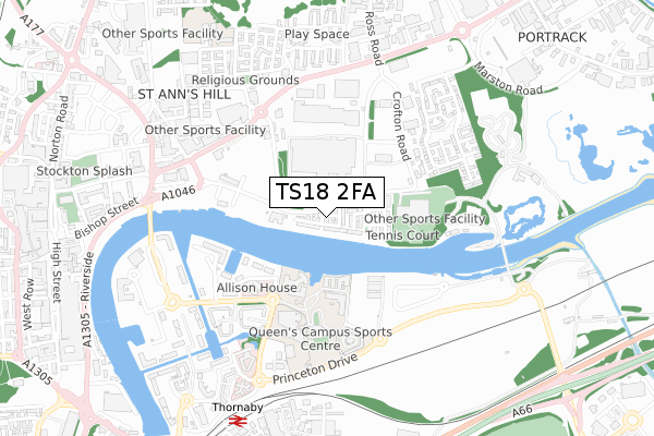
TS18 2FA is located in the Stockton Town Centre electoral ward, within the unitary authority of Stockton-on-Tees and the English Parliamentary constituency of Stockton North. The Sub Integrated Care Board (ICB) Location is NHS North East and North Cumbria ICB - 16C and the police force is Cleveland. This postcode has been in use since April 2018.


GetTheData
Source: OS Open Zoomstack (Ordnance Survey)
Licence: Open Government Licence (requires attribution)
Attribution: Contains OS data © Crown copyright and database right 2025
Source: Open Postcode Geo
Licence: Open Government Licence (requires attribution)
Attribution: Contains OS data © Crown copyright and database right 2025; Contains Royal Mail data © Royal Mail copyright and database right 2025; Source: Office for National Statistics licensed under the Open Government Licence v.3.0
| Easting | 445573 |
| Northing | 519182 |
| Latitude | 54.565833 |
| Longitude | -1.296704 |
GetTheData
Source: Open Postcode Geo
Licence: Open Government Licence
| Country | England |
| Postcode District | TS18 |
➜ See where TS18 is on a map ➜ Where is Stockton-on-Tees? | |
GetTheData
Source: Land Registry Price Paid Data
Licence: Open Government Licence
| Ward | Stockton Town Centre |
| Constituency | Stockton North |
GetTheData
Source: ONS Postcode Database
Licence: Open Government Licence
| Malleable Way (Crofton Road) | Portrack | 140m |
| Malleable Way (Crofton Road) | Portrack | 191m |
| Infinity Bridge (North Shore Road) | Portrack | 262m |
| Infinity Bridge (North Shore Road) | Portrack | 293m |
| Riverside College (Harvard Avenue) | Teesdale | 451m |
| Thornaby Station | 0.8km |
| Stockton Station | 1.5km |
| Middlesbrough Station | 4.3km |
GetTheData
Source: NaPTAN
Licence: Open Government Licence
| Percentage of properties with Next Generation Access | 100.0% |
| Percentage of properties with Superfast Broadband | 100.0% |
| Percentage of properties with Ultrafast Broadband | 100.0% |
| Percentage of properties with Full Fibre Broadband | 100.0% |
Superfast Broadband is between 30Mbps and 300Mbps
Ultrafast Broadband is > 300Mbps
| Percentage of properties unable to receive 2Mbps | 0.0% |
| Percentage of properties unable to receive 5Mbps | 0.0% |
| Percentage of properties unable to receive 10Mbps | 0.0% |
| Percentage of properties unable to receive 30Mbps | 0.0% |
GetTheData
Source: Ofcom
Licence: Ofcom Terms of Use (requires attribution)
GetTheData
Source: ONS Postcode Database
Licence: Open Government Licence


➜ Get more ratings from the Food Standards Agency
GetTheData
Source: Food Standards Agency
Licence: FSA terms & conditions
| Last Collection | |||
|---|---|---|---|
| Location | Mon-Fri | Sat | Distance |
| Harvard Avenue | 17:30 | 11:00 | 478m |
| St Cuthberts Road | 17:30 | 11:30 | 967m |
| Mandale Road | 17:45 | 11:00 | 972m |
GetTheData
Source: Dracos
Licence: Creative Commons Attribution-ShareAlike
The below table lists the International Territorial Level (ITL) codes (formerly Nomenclature of Territorial Units for Statistics (NUTS) codes) and Local Administrative Units (LAU) codes for TS18 2FA:
| ITL 1 Code | Name |
|---|---|
| TLC | North East (England) |
| ITL 2 Code | Name |
| TLC1 | Tees Valley and Durham |
| ITL 3 Code | Name |
| TLC11 | Hartlepool and Stockton-on-Tees |
| LAU 1 Code | Name |
| E06000004 | Stockton-on-Tees |
GetTheData
Source: ONS Postcode Directory
Licence: Open Government Licence
The below table lists the Census Output Area (OA), Lower Layer Super Output Area (LSOA), and Middle Layer Super Output Area (MSOA) for TS18 2FA:
| Code | Name | |
|---|---|---|
| OA | E00061853 | |
| LSOA | E01012266 | Stockton-on-Tees 014E |
| MSOA | E02002548 | Stockton-on-Tees 014 |
GetTheData
Source: ONS Postcode Directory
Licence: Open Government Licence
| TS18 2SY | Grainton Court | 92m |
| TS18 2SX | Brookby Court | 120m |
| TS18 2SU | Rollesby Way | 171m |
| TS18 2SQ | Laurelwood Road | 176m |
| TS18 2ST | Riverton Croft | 190m |
| TS18 2SS | Foston Way | 197m |
| TS18 2SH | Ivy Drive | 217m |
| TS18 2SR | Ilderton Road | 233m |
| TS17 6QA | Navigation Way | 334m |
| TS17 6EN | Fudan Way | 371m |
GetTheData
Source: Open Postcode Geo; Land Registry Price Paid Data
Licence: Open Government Licence