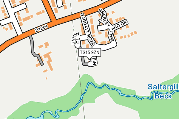
TS15 9ZN is located in the Yarm electoral ward, within the unitary authority of Stockton-on-Tees and the English Parliamentary constituency of Stockton South. The Sub Integrated Care Board (ICB) Location is NHS North East and North Cumbria ICB - 16C and the police force is Cleveland. This postcode has been in use since May 2017.


GetTheData
Source: OS OpenMap – Local (Ordnance Survey)
Source: OS VectorMap District (Ordnance Survey)
Licence: Open Government Licence (requires attribution)
| Easting | 441573 |
| Northing | 510789 |
| Latitude | 54.490753 |
| Longitude | -1.359743 |
GetTheData
Source: Open Postcode Geo
Licence: Open Government Licence
| Country | England |
| Postcode District | TS15 |
➜ See where TS15 is on a map ➜ Where is Yarm? | |
GetTheData
Source: Land Registry Price Paid Data
Licence: Open Government Licence
| Ward | Yarm |
| Constituency | Stockton South |
GetTheData
Source: ONS Postcode Database
Licence: Open Government Licence
1, PUFFIN COURT, YARM, TS15 9ZN 2022 19 JUL £162,000 |
2, PUFFIN COURT, YARM, TS15 9ZN 2022 29 APR £239,995 |
4, PUFFIN COURT, YARM, TS15 9ZN 2022 25 FEB £329,995 |
6, PUFFIN COURT, YARM, TS15 9ZN 2021 19 NOV £318,426 |
GetTheData
Source: HM Land Registry Price Paid Data
Licence: Contains HM Land Registry data © Crown copyright and database right 2024. This data is licensed under the Open Government Licence v3.0.
| Far End Farm (Worsall Road) | Yarm | 177m |
| Far End Farm (Worsall Road) | Yarm | 189m |
| Ryedale Close (Davenport Road) | Yarm | 338m |
| Eskdale Close (Davenport Road) | Yarm | 352m |
| Tall Trees Hotel (Worsall Road) | Yarm | 425m |
| Yarm Station | 0.6km |
| Allens West Station | 3.8km |
| Eaglescliffe Station | 4.4km |
GetTheData
Source: NaPTAN
Licence: Open Government Licence
| Percentage of properties with Next Generation Access | 100.0% |
| Percentage of properties with Superfast Broadband | 100.0% |
| Percentage of properties with Ultrafast Broadband | 0.0% |
| Percentage of properties with Full Fibre Broadband | 0.0% |
Superfast Broadband is between 30Mbps and 300Mbps
Ultrafast Broadband is > 300Mbps
| Median download speed | 100.0Mbps |
| Average download speed | 94.0Mbps |
| Maximum download speed | 350.00Mbps |
| Median upload speed | 0.9Mbps |
| Average upload speed | 0.9Mbps |
| Maximum upload speed | 1.05Mbps |
| Percentage of properties unable to receive 2Mbps | 0.0% |
| Percentage of properties unable to receive 5Mbps | 0.0% |
| Percentage of properties unable to receive 10Mbps | 0.0% |
| Percentage of properties unable to receive 30Mbps | 0.0% |
GetTheData
Source: Ofcom
Licence: Ofcom Terms of Use (requires attribution)
GetTheData
Source: ONS Postcode Database
Licence: Open Government Licence

➜ Get more ratings from the Food Standards Agency
GetTheData
Source: Food Standards Agency
Licence: FSA terms & conditions
| Last Collection | |||
|---|---|---|---|
| Location | Mon-Fri | Sat | Distance |
| Davenport Road | 16:45 | 10:30 | 559m |
| Fauconberg Way | 17:00 | 10:15 | 645m |
| Low Worsall | 16:45 | 10:15 | 1,805m |
GetTheData
Source: Dracos
Licence: Creative Commons Attribution-ShareAlike
The below table lists the International Territorial Level (ITL) codes (formerly Nomenclature of Territorial Units for Statistics (NUTS) codes) and Local Administrative Units (LAU) codes for TS15 9ZN:
| ITL 1 Code | Name |
|---|---|
| TLC | North East (England) |
| ITL 2 Code | Name |
| TLC1 | Tees Valley and Durham |
| ITL 3 Code | Name |
| TLC11 | Hartlepool and Stockton-on-Tees |
| LAU 1 Code | Name |
| E06000004 | Stockton-on-Tees |
GetTheData
Source: ONS Postcode Directory
Licence: Open Government Licence
The below table lists the Census Output Area (OA), Lower Layer Super Output Area (LSOA), and Middle Layer Super Output Area (MSOA) for TS15 9ZN:
| Code | Name | |
|---|---|---|
| OA | E00174138 | |
| LSOA | E01012235 | Stockton-on-Tees 024A |
| MSOA | E02002558 | Stockton-on-Tees 024 |
GetTheData
Source: ONS Postcode Directory
Licence: Open Government Licence
| TS15 9PE | Worsall Road | 136m |
| TS15 9UL | Eskdale Close | 243m |
| TS15 9UW | Troutsdale Close | 258m |
| TS15 9TJ | Carew Close | 300m |
| TS15 9UN | Ryedale Close | 361m |
| TS15 9TN | Davenport Road | 369m |
| TS15 9UD | Tindale Close | 394m |
| TS15 9UE | Nederdale Close | 419m |
| TS15 9FH | Allerton View | 450m |
| TS15 9FE | Morley Carr Drive | 468m |
GetTheData
Source: Open Postcode Geo; Land Registry Price Paid Data
Licence: Open Government Licence