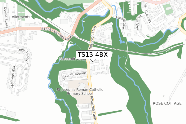
TS13 4BX is located in the Loftus electoral ward, within the unitary authority of Redcar and Cleveland and the English Parliamentary constituency of Middlesbrough South and East Cleveland. The Sub Integrated Care Board (ICB) Location is NHS North East and North Cumbria ICB - 16C and the police force is Cleveland. This postcode has been in use since November 2019.


GetTheData
Source: OS Open Zoomstack (Ordnance Survey)
Licence: Open Government Licence (requires attribution)
Attribution: Contains OS data © Crown copyright and database right 2025
Source: Open Postcode Geo
Licence: Open Government Licence (requires attribution)
Attribution: Contains OS data © Crown copyright and database right 2025; Contains Royal Mail data © Royal Mail copyright and database right 2025; Source: Office for National Statistics licensed under the Open Government Licence v.3.0
| Easting | 471843 |
| Northing | 517837 |
| Latitude | 54.550706 |
| Longitude | -0.890818 |
GetTheData
Source: Open Postcode Geo
Licence: Open Government Licence
| Country | England |
| Postcode District | TS13 |
➜ See where TS13 is on a map ➜ Where is Loftus? | |
GetTheData
Source: Land Registry Price Paid Data
Licence: Open Government Licence
| Ward | Loftus |
| Constituency | Middlesbrough South And East Cleveland |
GetTheData
Source: ONS Postcode Database
Licence: Open Government Licence
48, MIDDLE GILL CLOSE, LOFTUS, SALTBURN-BY-THE-SEA, TS13 4BX 2024 29 OCT £162,000 |
2024 23 AUG £180,000 |
28, MIDDLE GILL CLOSE, LOFTUS, SALTBURN-BY-THE-SEA, TS13 4BX 2023 31 AUG £180,000 |
2022 30 JUN £207,500 |
15, MIDDLE GILL CLOSE, LOFTUS, SALTBURN-BY-THE-SEA, TS13 4BX 2022 27 JAN £153,995 |
16, MIDDLE GILL CLOSE, LOFTUS, SALTBURN-BY-THE-SEA, TS13 4BX 2021 23 DEC £156,995 |
14, MIDDLE GILL CLOSE, LOFTUS, SALTBURN-BY-THE-SEA, TS13 4BX 2021 21 DEC £152,995 |
12, MIDDLE GILL CLOSE, LOFTUS, SALTBURN-BY-THE-SEA, TS13 4BX 2021 17 DEC £148,995 |
20, MIDDLE GILL CLOSE, LOFTUS, SALTBURN-BY-THE-SEA, TS13 4BX 2021 10 DEC £144,995 |
2021 30 NOV £184,995 |
GetTheData
Source: HM Land Registry Price Paid Data
Licence: Contains HM Land Registry data © Crown copyright and database right 2025. This data is licensed under the Open Government Licence v3.0.
| Old School (Rosecroft Lane) | Loftus | 65m |
| St Joseph's School (Rosecroft Lane) | Loftus | 171m |
| Zetland Road | Loftus | 383m |
| Zetland Road | Loftus | 402m |
| Station Road (West Road) | Loftus | 420m |
GetTheData
Source: NaPTAN
Licence: Open Government Licence
GetTheData
Source: ONS Postcode Database
Licence: Open Government Licence


➜ Get more ratings from the Food Standards Agency
GetTheData
Source: Food Standards Agency
Licence: FSA terms & conditions
The below table lists the International Territorial Level (ITL) codes (formerly Nomenclature of Territorial Units for Statistics (NUTS) codes) and Local Administrative Units (LAU) codes for TS13 4BX:
| ITL 1 Code | Name |
|---|---|
| TLC | North East (England) |
| ITL 2 Code | Name |
| TLC1 | Tees Valley and Durham |
| ITL 3 Code | Name |
| TLC12 | South Teesside |
| LAU 1 Code | Name |
| E06000003 | Redcar and Cleveland |
GetTheData
Source: ONS Postcode Directory
Licence: Open Government Licence
The below table lists the Census Output Area (OA), Lower Layer Super Output Area (LSOA), and Middle Layer Super Output Area (MSOA) for TS13 4BX:
| Code | Name | |
|---|---|---|
| OA | E00061203 | |
| LSOA | E01012137 | Redcar and Cleveland 016C |
| MSOA | E02002530 | Redcar and Cleveland 016 |
GetTheData
Source: ONS Postcode Directory
Licence: Open Government Licence
| TS13 4SP | Fircroft Court | 139m |
| TS13 4PH | Rosecroft Avenue | 175m |
| TS13 4NY | Laurel Park | 182m |
| TS13 4HL | Woodview | 275m |
| TS13 4YD | Hirds Drive | 285m |
| TS13 4QB | Station Road | 294m |
| TS13 4YB | Stable Court | 296m |
| TS13 4PY | Liverton Road | 308m |
| TS13 4YA | Hillcrest Drive | 314m |
| TS13 4PL | Co Operative Terrace | 330m |
GetTheData
Source: Open Postcode Geo; Land Registry Price Paid Data
Licence: Open Government Licence