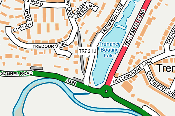
TR7 2HU is located in the Newquay Trenance electoral ward, within the unitary authority of Cornwall and the English Parliamentary constituency of St Austell and Newquay. The Sub Integrated Care Board (ICB) Location is NHS Cornwall and the Isles of Scilly ICB - 11N and the police force is Devon & Cornwall. This postcode has been in use since January 1980.


GetTheData
Source: OS OpenMap – Local (Ordnance Survey)
Source: OS VectorMap District (Ordnance Survey)
Licence: Open Government Licence (requires attribution)
| Easting | 181431 |
| Northing | 60839 |
| Latitude | 50.406674 |
| Longitude | -5.077347 |
GetTheData
Source: Open Postcode Geo
Licence: Open Government Licence
| Country | England |
| Postcode District | TR7 |
➜ See where TR7 is on a map ➜ Where is Newquay? | |
GetTheData
Source: Land Registry Price Paid Data
Licence: Open Government Licence
Elevation or altitude of TR7 2HU as distance above sea level:
| Metres | Feet | |
|---|---|---|
| Elevation | 10m | 33ft |
Elevation is measured from the approximate centre of the postcode, to the nearest point on an OS contour line from OS Terrain 50, which has contour spacing of ten vertical metres.
➜ How high above sea level am I? Find the elevation of your current position using your device's GPS.
GetTheData
Source: Open Postcode Elevation
Licence: Open Government Licence
| Ward | Newquay Trenance |
| Constituency | St Austell And Newquay |
GetTheData
Source: ONS Postcode Database
Licence: Open Government Licence
| Mulbury Bush (Rawley Lane) | Trenance | 232m |
| Trenance Gardens (Trevemper Road) | Trenance | 278m |
| Hawkins Road (Hawkins Drive) | Trenance | 307m |
| Trenance Gardens (Trevemper Road) | Trenance | 308m |
| Trenance Lodge (Trenance Road) | Trenance | 349m |
| Newquay Station | 0.9km |
| Quintrell Downs Station | 3.5km |
GetTheData
Source: NaPTAN
Licence: Open Government Licence
GetTheData
Source: ONS Postcode Database
Licence: Open Government Licence


➜ Get more ratings from the Food Standards Agency
GetTheData
Source: Food Standards Agency
Licence: FSA terms & conditions
| Last Collection | |||
|---|---|---|---|
| Location | Mon-Fri | Sat | Distance |
| Treforda Road | 17:45 | 11:00 | 252m |
| Trevemper Road | 17:45 | 11:00 | 256m |
| Listry Road | 17:30 | 11:00 | 397m |
GetTheData
Source: Dracos
Licence: Creative Commons Attribution-ShareAlike
| Risk of TR7 2HU flooding from rivers and sea | Medium |
| ➜ TR7 2HU flood map | |
GetTheData
Source: Open Flood Risk by Postcode
Licence: Open Government Licence
The below table lists the International Territorial Level (ITL) codes (formerly Nomenclature of Territorial Units for Statistics (NUTS) codes) and Local Administrative Units (LAU) codes for TR7 2HU:
| ITL 1 Code | Name |
|---|---|
| TLK | South West (England) |
| ITL 2 Code | Name |
| TLK3 | Cornwall and Isles of Scilly |
| ITL 3 Code | Name |
| TLK30 | Cornwall and Isles of Scilly |
| LAU 1 Code | Name |
| E06000052 | Cornwall |
GetTheData
Source: ONS Postcode Directory
Licence: Open Government Licence
The below table lists the Census Output Area (OA), Lower Layer Super Output Area (LSOA), and Middle Layer Super Output Area (MSOA) for TR7 2HU:
| Code | Name | |
|---|---|---|
| OA | E00096120 | |
| LSOA | E01019021 | Cornwall 021D |
| MSOA | E02003955 | Cornwall 021 |
GetTheData
Source: ONS Postcode Directory
Licence: Open Government Licence
| TR7 2HY | Trenance Lane | 31m |
| TR7 2HT | Rawley Lane | 48m |
| TR7 2EU | Rawley Lane | 100m |
| TR7 2EX | Rawley Lane | 162m |
| TR7 2HA | Linden Crescent | 164m |
| TR7 2EB | Hawkins Road | 185m |
| TR7 2EY | Tredour Road | 196m |
| TR7 2HX | Trenance Lane | 202m |
| TR7 2ET | Rawley Lane | 203m |
| TR7 2HR | Trevemper Road | 219m |
GetTheData
Source: Open Postcode Geo; Land Registry Price Paid Data
Licence: Open Government Licence