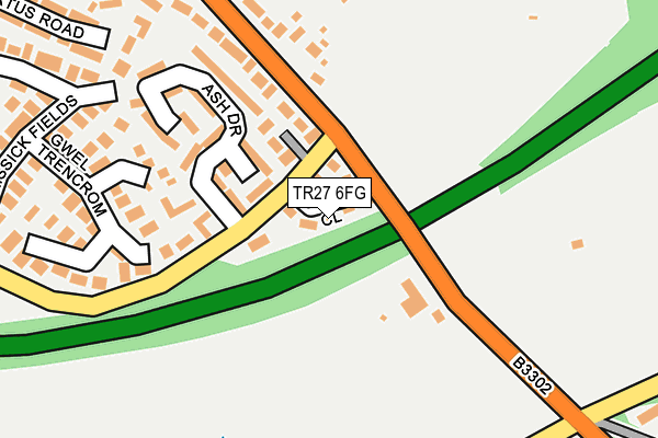
TR27 6FG is located in the Long Rock, Marazion & St Erth electoral ward, within the unitary authority of Cornwall and the English Parliamentary constituency of St Ives. The Sub Integrated Care Board (ICB) Location is NHS Cornwall and the Isles of Scilly ICB - 11N and the police force is Devon & Cornwall. This postcode has been in use since June 2017.


GetTheData
Source: OS OpenMap – Local (Ordnance Survey)
Source: OS VectorMap District (Ordnance Survey)
Licence: Open Government Licence (requires attribution)
| Easting | 155965 |
| Northing | 36210 |
| Latitude | 50.175540 |
| Longitude | -5.419242 |
GetTheData
Source: Open Postcode Geo
Licence: Open Government Licence
| Country | England |
| Postcode District | TR27 |
➜ See where TR27 is on a map | |
GetTheData
Source: Land Registry Price Paid Data
Licence: Open Government Licence
| Ward | Long Rock, Marazion & St Erth |
| Constituency | St Ives |
GetTheData
Source: ONS Postcode Database
Licence: Open Government Licence
| Ash Drive (Water Lane) | Chenhalls | 77m |
| Ash Drive (Water Lane) | Chenhalls | 80m |
| Tolroy Holiday Village (Tolroy Road) | Chenhalls | 307m |
| Tolroy Holiday Village (Tolroy Road) | Chenhalls | 311m |
| Trelissick Road (Water Lane) | Hayle | 421m |
| Hayle Station | 1.1km |
| Lelant Station | 1.6km |
| Lelant Saltings Station | 1.6km |
GetTheData
Source: NaPTAN
Licence: Open Government Licence
| Percentage of properties with Next Generation Access | 0.0% |
| Percentage of properties with Superfast Broadband | 0.0% |
| Percentage of properties with Ultrafast Broadband | 0.0% |
| Percentage of properties with Full Fibre Broadband | 0.0% |
Superfast Broadband is between 30Mbps and 300Mbps
Ultrafast Broadband is > 300Mbps
| Median download speed | 18.8Mbps |
| Average download speed | 17.8Mbps |
| Maximum download speed | 21.13Mbps |
| Median upload speed | 1.1Mbps |
| Average upload speed | 1.1Mbps |
| Maximum upload speed | 1.24Mbps |
| Percentage of properties unable to receive 2Mbps | 0.0% |
| Percentage of properties unable to receive 5Mbps | 0.0% |
| Percentage of properties unable to receive 10Mbps | 0.0% |
| Percentage of properties unable to receive 30Mbps | 100.0% |
GetTheData
Source: Ofcom
Licence: Ofcom Terms of Use (requires attribution)
GetTheData
Source: ONS Postcode Database
Licence: Open Government Licence


➜ Get more ratings from the Food Standards Agency
GetTheData
Source: Food Standards Agency
Licence: FSA terms & conditions
| Last Collection | |||
|---|---|---|---|
| Location | Mon-Fri | Sat | Distance |
| Hayle Delivery Office | 17:15 | 11:45 | 964m |
| Hayle Post Office | 18:00 | 11:00 | 1,080m |
| St Elwyns Church | 17:15 | 11:15 | 1,398m |
GetTheData
Source: Dracos
Licence: Creative Commons Attribution-ShareAlike
The below table lists the International Territorial Level (ITL) codes (formerly Nomenclature of Territorial Units for Statistics (NUTS) codes) and Local Administrative Units (LAU) codes for TR27 6FG:
| ITL 1 Code | Name |
|---|---|
| TLK | South West (England) |
| ITL 2 Code | Name |
| TLK3 | Cornwall and Isles of Scilly |
| ITL 3 Code | Name |
| TLK30 | Cornwall and Isles of Scilly |
| LAU 1 Code | Name |
| E06000052 | Cornwall |
GetTheData
Source: ONS Postcode Directory
Licence: Open Government Licence
The below table lists the Census Output Area (OA), Lower Layer Super Output Area (LSOA), and Middle Layer Super Output Area (MSOA) for TR27 6FG:
| Code | Name | |
|---|---|---|
| OA | E00096037 | |
| LSOA | E01019007 | Cornwall 061E |
| MSOA | E02003946 | Cornwall 061 |
GetTheData
Source: ONS Postcode Directory
Licence: Open Government Licence
| TR27 6LD | Water Lane | 72m |
| TR27 6PQ | Ash Grove | 119m |
| TR27 6HF | Mellanear Road | 135m |
| TR27 6PL | Birch Grove | 139m |
| TR27 6PF | Ash Drive | 145m |
| TR27 6PJ | Gwel Trencrom | 190m |
| TR27 4QT | Mellanear Road | 211m |
| TR27 4QP | Hamilton Close | 315m |
| TR27 4JQ | Albertus Road | 338m |
| TR27 6HZ | Trelissick Fields | 343m |
GetTheData
Source: Open Postcode Geo; Land Registry Price Paid Data
Licence: Open Government Licence