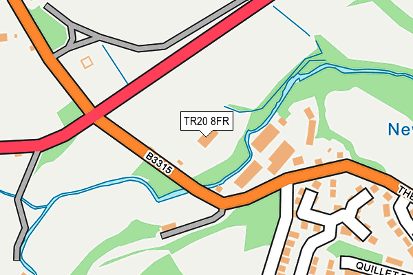
TR20 8FR is located in the Mousehole, Newlyn & St Buryan electoral ward, within the unitary authority of Cornwall and the English Parliamentary constituency of St Ives. The Sub Integrated Care Board (ICB) Location is NHS Cornwall and the Isles of Scilly ICB - 11N and the police force is Devon & Cornwall. This postcode has been in use since November 2012.


GetTheData
Source: OS OpenMap – Local (Ordnance Survey)
Source: OS VectorMap District (Ordnance Survey)
Licence: Open Government Licence (requires attribution)
| Easting | 145464 |
| Northing | 29370 |
| Latitude | 50.109733 |
| Longitude | -5.561400 |
GetTheData
Source: Open Postcode Geo
Licence: Open Government Licence
| Country | England |
| Postcode District | TR20 |
➜ See where TR20 is on a map | |
GetTheData
Source: Land Registry Price Paid Data
Licence: Open Government Licence
Elevation or altitude of TR20 8FR as distance above sea level:
| Metres | Feet | |
|---|---|---|
| Elevation | 20m | 66ft |
Elevation is measured from the approximate centre of the postcode, to the nearest point on an OS contour line from OS Terrain 50, which has contour spacing of ten vertical metres.
➜ How high above sea level am I? Find the elevation of your current position using your device's GPS.
GetTheData
Source: Open Postcode Elevation
Licence: Open Government Licence
| Ward | Mousehole, Newlyn & St Buryan |
| Constituency | St Ives |
GetTheData
Source: ONS Postcode Database
Licence: Open Government Licence
| Newlyn Cross Roads | Newlyn | 101m |
| Newlyn Cross Roads (B3315) | Newlyn | 113m |
| Crossroads | Newlyn | 164m |
| Crossroads | Newlyn | 169m |
| Newlyn Coombe (The Coombe) | Newlyn | 283m |
| Penzance Station | 2.5km |
GetTheData
Source: NaPTAN
Licence: Open Government Licence
GetTheData
Source: ONS Postcode Database
Licence: Open Government Licence


➜ Get more ratings from the Food Standards Agency
GetTheData
Source: Food Standards Agency
Licence: FSA terms & conditions
| Last Collection | |||
|---|---|---|---|
| Location | Mon-Fri | Sat | Distance |
| Carn Road | 16:00 | 11:30 | 903m |
| Alverton Post Office | 17:15 | 11:30 | 911m |
| Lidden Estate | 16:00 | 11:30 | 933m |
GetTheData
Source: Dracos
Licence: Creative Commons Attribution-ShareAlike
| Risk of TR20 8FR flooding from rivers and sea | Medium |
| ➜ TR20 8FR flood map | |
GetTheData
Source: Open Flood Risk by Postcode
Licence: Open Government Licence
The below table lists the International Territorial Level (ITL) codes (formerly Nomenclature of Territorial Units for Statistics (NUTS) codes) and Local Administrative Units (LAU) codes for TR20 8FR:
| ITL 1 Code | Name |
|---|---|
| TLK | South West (England) |
| ITL 2 Code | Name |
| TLK3 | Cornwall and Isles of Scilly |
| ITL 3 Code | Name |
| TLK30 | Cornwall and Isles of Scilly |
| LAU 1 Code | Name |
| E06000052 | Cornwall |
GetTheData
Source: ONS Postcode Directory
Licence: Open Government Licence
The below table lists the Census Output Area (OA), Lower Layer Super Output Area (LSOA), and Middle Layer Super Output Area (MSOA) for TR20 8FR:
| Code | Name | |
|---|---|---|
| OA | E00096015 | |
| LSOA | E01019003 | Cornwall 070C |
| MSOA | E02003951 | Cornwall 070 |
GetTheData
Source: ONS Postcode Directory
Licence: Open Government Licence
| TR20 8TL | Stable Hobba | 85m |
| TR18 5QY | Tregie | 179m |
| TR18 5QX | Polgarth | 251m |
| TR18 5QU | Coombe Vale | 262m |
| TR18 5QL | Lower Gurnick Road | 328m |
| TR18 5QW | St Golder Road | 331m |
| TR20 8TR | 332m | |
| TR18 5QR | Quillet Road | 337m |
| TR20 8TJ | 427m | |
| TR18 5QJ | Garth Road | 466m |
GetTheData
Source: Open Postcode Geo; Land Registry Price Paid Data
Licence: Open Government Licence