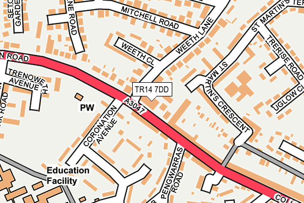
TR14 7DD is located in the Camborne West & Treswithian electoral ward, within the unitary authority of Cornwall and the English Parliamentary constituency of Camborne and Redruth. The Sub Integrated Care Board (ICB) Location is NHS Cornwall and the Isles of Scilly ICB - 11N and the police force is Devon & Cornwall. This postcode has been in use since April 2017.


GetTheData
Source: OS OpenMap – Local (Ordnance Survey)
Source: OS VectorMap District (Ordnance Survey)
Licence: Open Government Licence (requires attribution)
| Easting | 164113 |
| Northing | 40321 |
| Latitude | 50.215751 |
| Longitude | -5.307880 |
GetTheData
Source: Open Postcode Geo
Licence: Open Government Licence
| Country | England |
| Postcode District | TR14 |
➜ See where TR14 is on a map ➜ Where is Camborne? | |
GetTheData
Source: Land Registry Price Paid Data
Licence: Open Government Licence
| Ward | Camborne West & Treswithian |
| Constituency | Camborne And Redruth |
GetTheData
Source: ONS Postcode Database
Licence: Open Government Licence
| Fire Station (College Street) | Treswithian | 36m |
| Weeth Close (Weeth Lane) | Treswithian | 38m |
| Weeth Close (Weeth Lane) | Treswithian | 48m |
| Fire Station (College Street) | Treswithian | 54m |
| Crane Road | Treswithian | 258m |
| Camborne Station | 1km |
GetTheData
Source: NaPTAN
Licence: Open Government Licence
GetTheData
Source: ONS Postcode Database
Licence: Open Government Licence


➜ Get more ratings from the Food Standards Agency
GetTheData
Source: Food Standards Agency
Licence: FSA terms & conditions
| Last Collection | |||
|---|---|---|---|
| Location | Mon-Fri | Sat | Distance |
| Tehidy Road Post Office | 17:00 | 11:00 | 553m |
| Treswithian | 16:45 | 08:00 | 564m |
| Camborne Post Office | 18:15 | 12:00 | 647m |
GetTheData
Source: Dracos
Licence: Creative Commons Attribution-ShareAlike
The below table lists the International Territorial Level (ITL) codes (formerly Nomenclature of Territorial Units for Statistics (NUTS) codes) and Local Administrative Units (LAU) codes for TR14 7DD:
| ITL 1 Code | Name |
|---|---|
| TLK | South West (England) |
| ITL 2 Code | Name |
| TLK3 | Cornwall and Isles of Scilly |
| ITL 3 Code | Name |
| TLK30 | Cornwall and Isles of Scilly |
| LAU 1 Code | Name |
| E06000052 | Cornwall |
GetTheData
Source: ONS Postcode Directory
Licence: Open Government Licence
The below table lists the Census Output Area (OA), Lower Layer Super Output Area (LSOA), and Middle Layer Super Output Area (MSOA) for TR14 7DD:
| Code | Name | |
|---|---|---|
| OA | E00095315 | |
| LSOA | E01018875 | Cornwall 053B |
| MSOA | E02003924 | Cornwall 053 |
GetTheData
Source: ONS Postcode Directory
Licence: Open Government Licence
| TR14 7JY | College Street | 43m |
| TR14 7JL | Weeth Lane | 66m |
| TR14 7JZ | College Street | 73m |
| TR14 7JN | Weeth Lane | 107m |
| TR14 7HH | St Martins Crescent | 113m |
| TR14 7JJ | Weeth Close | 115m |
| TR14 7LA | College Street | 139m |
| TR14 7EL | Pengwarras Road | 144m |
| TR14 7JH | Mitchell Road | 151m |
| TR14 7PB | Treswithian Road | 160m |
GetTheData
Source: Open Postcode Geo; Land Registry Price Paid Data
Licence: Open Government Licence