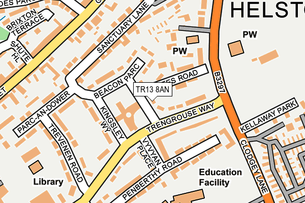
TR13 8AN lies on Beacon Parc in Helston. TR13 8AN is located in the Helston North electoral ward, within the unitary authority of Cornwall and the English Parliamentary constituency of St Ives. The Sub Integrated Care Board (ICB) Location is NHS Cornwall and the Isles of Scilly ICB - 11N and the police force is Devon & Cornwall. This postcode has been in use since January 1980.


GetTheData
Source: OS OpenMap – Local (Ordnance Survey)
Source: OS VectorMap District (Ordnance Survey)
Licence: Open Government Licence (requires attribution)
| Easting | 166373 |
| Northing | 27528 |
| Latitude | 50.101780 |
| Longitude | -5.268408 |
GetTheData
Source: Open Postcode Geo
Licence: Open Government Licence
| Street | Beacon Parc |
| Town/City | Helston |
| Country | England |
| Postcode District | TR13 |
➜ See where TR13 is on a map ➜ Where is Helston? | |
GetTheData
Source: Land Registry Price Paid Data
Licence: Open Government Licence
Elevation or altitude of TR13 8AN as distance above sea level:
| Metres | Feet | |
|---|---|---|
| Elevation | 80m | 262ft |
Elevation is measured from the approximate centre of the postcode, to the nearest point on an OS contour line from OS Terrain 50, which has contour spacing of ten vertical metres.
➜ How high above sea level am I? Find the elevation of your current position using your device's GPS.
GetTheData
Source: Open Postcode Elevation
Licence: Open Government Licence
| Ward | Helston North |
| Constituency | St Ives |
GetTheData
Source: ONS Postcode Database
Licence: Open Government Licence
| Kingsley Way (Trengrouse Way) | Helston | 107m |
| Godolphin Road | Helston | 288m |
| Co-op (The Parade) | Helston | 317m |
| Tesco | Helston | 337m |
| Tyre Centre (Clodgey Lane) | Helston | 382m |
GetTheData
Source: NaPTAN
Licence: Open Government Licence
| Percentage of properties with Next Generation Access | 66.7% |
| Percentage of properties with Superfast Broadband | 66.7% |
| Percentage of properties with Ultrafast Broadband | 66.7% |
| Percentage of properties with Full Fibre Broadband | 66.7% |
Superfast Broadband is between 30Mbps and 300Mbps
Ultrafast Broadband is > 300Mbps
| Median download speed | 13.3Mbps |
| Average download speed | 14.4Mbps |
| Maximum download speed | 24.31Mbps |
| Median upload speed | 1.1Mbps |
| Average upload speed | 1.1Mbps |
| Maximum upload speed | 1.25Mbps |
| Percentage of properties unable to receive 2Mbps | 0.0% |
| Percentage of properties unable to receive 5Mbps | 0.0% |
| Percentage of properties unable to receive 10Mbps | 0.0% |
| Percentage of properties unable to receive 30Mbps | 33.3% |
GetTheData
Source: Ofcom
Licence: Ofcom Terms of Use (requires attribution)
GetTheData
Source: ONS Postcode Database
Licence: Open Government Licence


➜ Get more ratings from the Food Standards Agency
GetTheData
Source: Food Standards Agency
Licence: FSA terms & conditions
| Last Collection | |||
|---|---|---|---|
| Location | Mon-Fri | Sat | Distance |
| Tesco (Clodgey Lane) | 17:15 | 11:00 | 374m |
| Meneage Street | 17:45 | 11:30 | 443m |
| Church Street | 17:25 | 11:00 | 520m |
GetTheData
Source: Dracos
Licence: Creative Commons Attribution-ShareAlike
The below table lists the International Territorial Level (ITL) codes (formerly Nomenclature of Territorial Units for Statistics (NUTS) codes) and Local Administrative Units (LAU) codes for TR13 8AN:
| ITL 1 Code | Name |
|---|---|
| TLK | South West (England) |
| ITL 2 Code | Name |
| TLK3 | Cornwall and Isles of Scilly |
| ITL 3 Code | Name |
| TLK30 | Cornwall and Isles of Scilly |
| LAU 1 Code | Name |
| E06000052 | Cornwall |
GetTheData
Source: ONS Postcode Directory
Licence: Open Government Licence
The below table lists the Census Output Area (OA), Lower Layer Super Output Area (LSOA), and Middle Layer Super Output Area (MSOA) for TR13 8AN:
| Code | Name | |
|---|---|---|
| OA | E00095365 | |
| LSOA | E01018888 | Cornwall 071G |
| MSOA | E02003928 | Cornwall 071 |
GetTheData
Source: ONS Postcode Directory
Licence: Open Government Licence
| TR13 8AW | Oates Road | 87m |
| TR13 8AE | Trengrouse Way | 87m |
| TR13 8AL | Beacon Parc | 91m |
| TR13 8AP | Vyvyan Place | 103m |
| TR13 8AJ | Kingsley Way | 115m |
| TR13 8UG | Sanctuary Lane | 136m |
| TR13 8AR | Penberthy Road | 144m |
| TR13 8UF | Sanctuary Lane | 148m |
| TR13 8AF | Trengrouse Way | 154m |
| TR13 8UE | Wendron Terrace | 161m |
GetTheData
Source: Open Postcode Geo; Land Registry Price Paid Data
Licence: Open Government Licence