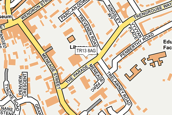
TR13 8AG lies on Trengrouse Way in Helston. TR13 8AG is located in the Helston North electoral ward, within the unitary authority of Cornwall and the English Parliamentary constituency of St Ives. The Sub Integrated Care Board (ICB) Location is NHS Cornwall and the Isles of Scilly ICB - 11N and the police force is Devon & Cornwall. This postcode has been in use since January 1980.


GetTheData
Source: OS OpenMap – Local (Ordnance Survey)
Source: OS VectorMap District (Ordnance Survey)
Licence: Open Government Licence (requires attribution)
| Easting | 166142 |
| Northing | 27399 |
| Latitude | 50.100530 |
| Longitude | -5.271554 |
GetTheData
Source: Open Postcode Geo
Licence: Open Government Licence
| Street | Trengrouse Way |
| Town/City | Helston |
| Country | England |
| Postcode District | TR13 |
➜ See where TR13 is on a map ➜ Where is Helston? | |
GetTheData
Source: Land Registry Price Paid Data
Licence: Open Government Licence
Elevation or altitude of TR13 8AG as distance above sea level:
| Metres | Feet | |
|---|---|---|
| Elevation | 70m | 230ft |
Elevation is measured from the approximate centre of the postcode, to the nearest point on an OS contour line from OS Terrain 50, which has contour spacing of ten vertical metres.
➜ How high above sea level am I? Find the elevation of your current position using your device's GPS.
GetTheData
Source: Open Postcode Elevation
Licence: Open Government Licence
| Ward | Helston North |
| Constituency | St Ives |
GetTheData
Source: ONS Postcode Database
Licence: Open Government Licence
THE OLD FIRE STATION, TRENGROUSE WAY, HELSTON, TR13 8AG 2008 11 FEB £248,000 |
GetTheData
Source: HM Land Registry Price Paid Data
Licence: Contains HM Land Registry data © Crown copyright and database right 2025. This data is licensed under the Open Government Licence v3.0.
| Co-op (The Parade) | Helston | 112m |
| Olivers (Meneage Street) | Helston | 157m |
| The Parade | Helston | 168m |
| Kingsley Way (Trengrouse Way) | Helston | 178m |
| Seven Stars (Coinagehall Street) | Helston | 354m |
GetTheData
Source: NaPTAN
Licence: Open Government Licence
GetTheData
Source: ONS Postcode Database
Licence: Open Government Licence


➜ Get more ratings from the Food Standards Agency
GetTheData
Source: Food Standards Agency
Licence: FSA terms & conditions
| Last Collection | |||
|---|---|---|---|
| Location | Mon-Fri | Sat | Distance |
| Meneage Street | 17:45 | 11:30 | 228m |
| Grange Road | 17:25 | 10:00 | 297m |
| Helston Post Office | 18:00 | 12:00 | 305m |
GetTheData
Source: Dracos
Licence: Creative Commons Attribution-ShareAlike
The below table lists the International Territorial Level (ITL) codes (formerly Nomenclature of Territorial Units for Statistics (NUTS) codes) and Local Administrative Units (LAU) codes for TR13 8AG:
| ITL 1 Code | Name |
|---|---|
| TLK | South West (England) |
| ITL 2 Code | Name |
| TLK3 | Cornwall and Isles of Scilly |
| ITL 3 Code | Name |
| TLK30 | Cornwall and Isles of Scilly |
| LAU 1 Code | Name |
| E06000052 | Cornwall |
GetTheData
Source: ONS Postcode Directory
Licence: Open Government Licence
The below table lists the Census Output Area (OA), Lower Layer Super Output Area (LSOA), and Middle Layer Super Output Area (MSOA) for TR13 8AG:
| Code | Name | |
|---|---|---|
| OA | E00095365 | |
| LSOA | E01018888 | Cornwall 071G |
| MSOA | E02003928 | Cornwall 071 |
GetTheData
Source: ONS Postcode Directory
Licence: Open Government Licence
| TR13 8AH | Trevenen Road | 55m |
| TR13 8AD | Horse & Jockey Lane | 81m |
| TR13 8AQ | Parc An Dower | 103m |
| TR13 8QY | Meneage Street | 110m |
| TR13 8GQ | Tremenva Court | 115m |
| TR13 8BE | Meneage Street | 122m |
| TR13 8AB | Meneage Street | 134m |
| TR13 8RB | Meneage Street | 144m |
| TR13 8PT | Wendron Street | 149m |
| TR13 8AA | Meneage Street | 151m |
GetTheData
Source: Open Postcode Geo; Land Registry Price Paid Data
Licence: Open Government Licence