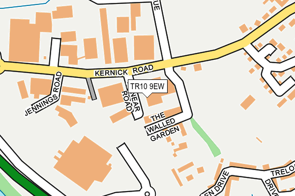
TR10 9EW lies on Annear Road in Penryn. TR10 9EW is located in the Penryn electoral ward, within the unitary authority of Cornwall and the English Parliamentary constituency of Truro and Falmouth. The Sub Integrated Care Board (ICB) Location is NHS Cornwall and the Isles of Scilly ICB - 11N and the police force is Devon & Cornwall. This postcode has been in use since January 1980.


GetTheData
Source: OS OpenMap – Local (Ordnance Survey)
Source: OS VectorMap District (Ordnance Survey)
Licence: Open Government Licence (requires attribution)
| Easting | 177268 |
| Northing | 33987 |
| Latitude | 50.163968 |
| Longitude | -5.120068 |
GetTheData
Source: Open Postcode Geo
Licence: Open Government Licence
| Street | Annear Road |
| Town/City | Penryn |
| Country | England |
| Postcode District | TR10 |
➜ See where TR10 is on a map ➜ Where is Penryn? | |
GetTheData
Source: Land Registry Price Paid Data
Licence: Open Government Licence
Elevation or altitude of TR10 9EW as distance above sea level:
| Metres | Feet | |
|---|---|---|
| Elevation | 80m | 262ft |
Elevation is measured from the approximate centre of the postcode, to the nearest point on an OS contour line from OS Terrain 50, which has contour spacing of ten vertical metres.
➜ How high above sea level am I? Find the elevation of your current position using your device's GPS.
GetTheData
Source: Open Postcode Elevation
Licence: Open Government Licence
| Ward | Penryn |
| Constituency | Truro And Falmouth |
GetTheData
Source: ONS Postcode Database
Licence: Open Government Licence
| Kernick Ind Estate | Penryn | 44m |
| Kernick Inst Estate (Kernick Road) | Penryn | 57m |
| Kernick Road | Penryn | 186m |
| Kernick Road | Penryn | 240m |
| Asda Mainroad | Penryn | 272m |
| Penryn Station | 1km |
| Penmere Station | 3km |
| Falmouth Town Station | 4.3km |
GetTheData
Source: NaPTAN
Licence: Open Government Licence
GetTheData
Source: ONS Postcode Database
Licence: Open Government Licence


➜ Get more ratings from the Food Standards Agency
GetTheData
Source: Food Standards Agency
Licence: FSA terms & conditions
| Last Collection | |||
|---|---|---|---|
| Location | Mon-Fri | Sat | Distance |
| Kernick Industrial Estate | 66m | ||
| Poltisko Road | 16:45 | 11:00 | 603m |
| Polwithen Road | 17:00 | 11:30 | 692m |
GetTheData
Source: Dracos
Licence: Creative Commons Attribution-ShareAlike
The below table lists the International Territorial Level (ITL) codes (formerly Nomenclature of Territorial Units for Statistics (NUTS) codes) and Local Administrative Units (LAU) codes for TR10 9EW:
| ITL 1 Code | Name |
|---|---|
| TLK | South West (England) |
| ITL 2 Code | Name |
| TLK3 | Cornwall and Isles of Scilly |
| ITL 3 Code | Name |
| TLK30 | Cornwall and Isles of Scilly |
| LAU 1 Code | Name |
| E06000052 | Cornwall |
GetTheData
Source: ONS Postcode Directory
Licence: Open Government Licence
The below table lists the Census Output Area (OA), Lower Layer Super Output Area (LSOA), and Middle Layer Super Output Area (MSOA) for TR10 9EW:
| Code | Name | |
|---|---|---|
| OA | E00095098 | |
| LSOA | E01018834 | Cornwall 060A |
| MSOA | E02003914 | Cornwall 060 |
GetTheData
Source: ONS Postcode Directory
Licence: Open Government Licence
| TR10 9DB | The Walled Garden | 78m |
| TR10 9DQ | Kernick Road | 141m |
| TR10 9DG | Kernick Park | 170m |
| TR10 8QE | Little Oaks | 251m |
| TR10 8PD | Kernick Road | 279m |
| TR10 9WT | Trelowen Drive | 287m |
| TR10 9WS | Trelowen Drive | 303m |
| TR10 8RX | Little Oaks | 322m |
| TR10 8QF | Little Oaks | 345m |
| TR10 8PF | Woodland Avenue | 351m |
GetTheData
Source: Open Postcode Geo; Land Registry Price Paid Data
Licence: Open Government Licence