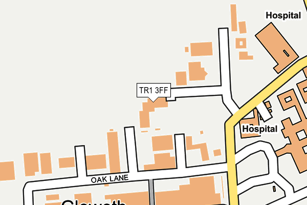
TR1 3FF is located in the Gloweth, Malabar & Shortlanesend electoral ward, within the unitary authority of Cornwall and the English Parliamentary constituency of Truro and Falmouth. The Sub Integrated Care Board (ICB) Location is NHS Cornwall and the Isles of Scilly ICB - 11N and the police force is Devon & Cornwall. This postcode has been in use since December 2011.


GetTheData
Source: OS OpenMap – Local (Ordnance Survey)
Source: OS VectorMap District (Ordnance Survey)
Licence: Open Government Licence (requires attribution)
| Easting | 179377 |
| Northing | 45333 |
| Latitude | 50.266650 |
| Longitude | -5.097179 |
GetTheData
Source: Open Postcode Geo
Licence: Open Government Licence
| Country | England |
| Postcode District | TR1 |
➜ See where TR1 is on a map ➜ Where is Truro? | |
GetTheData
Source: Land Registry Price Paid Data
Licence: Open Government Licence
Elevation or altitude of TR1 3FF as distance above sea level:
| Metres | Feet | |
|---|---|---|
| Elevation | 90m | 295ft |
Elevation is measured from the approximate centre of the postcode, to the nearest point on an OS contour line from OS Terrain 50, which has contour spacing of ten vertical metres.
➜ How high above sea level am I? Find the elevation of your current position using your device's GPS.
GetTheData
Source: Open Postcode Elevation
Licence: Open Government Licence
| Ward | Gloweth, Malabar & Shortlanesend |
| Constituency | Truro And Falmouth |
GetTheData
Source: ONS Postcode Database
Licence: Open Government Licence
| Homebase (Tresawls Road) | Treliske | 233m |
| Trelawny Entrance | Treliske Hospital | 271m |
| Trelawny Entrance | Treliske Hospital | 274m |
| Rch Trelawny Wing | Treliske Hospital | 350m |
| Rch Trelawny Wing | Treliske Hospital | 363m |
| Truro Station | 2.3km |
GetTheData
Source: NaPTAN
Licence: Open Government Licence
Estimated total energy consumption in TR1 3FF by fuel type, 2015.
| Consumption (kWh) | 16,404 |
|---|---|
| Meter count | 9 |
| Mean (kWh/meter) | 1,823 |
| Median (kWh/meter) | 1,631 |
GetTheData
Source: Postcode level gas estimates: 2015 (experimental)
Source: Postcode level electricity estimates: 2015 (experimental)
Licence: Open Government Licence
GetTheData
Source: ONS Postcode Database
Licence: Open Government Licence


➜ Get more ratings from the Food Standards Agency
GetTheData
Source: Food Standards Agency
Licence: FSA terms & conditions
| Last Collection | |||
|---|---|---|---|
| Location | Mon-Fri | Sat | Distance |
| Treyew Road | 16:45 | 12:10 | 2,344m |
| Railway Station | 17:00 | 11:35 | 2,379m |
| Hendra Post Office | 17:00 | 11:55 | 2,591m |
GetTheData
Source: Dracos
Licence: Creative Commons Attribution-ShareAlike
The below table lists the International Territorial Level (ITL) codes (formerly Nomenclature of Territorial Units for Statistics (NUTS) codes) and Local Administrative Units (LAU) codes for TR1 3FF:
| ITL 1 Code | Name |
|---|---|
| TLK | South West (England) |
| ITL 2 Code | Name |
| TLK3 | Cornwall and Isles of Scilly |
| ITL 3 Code | Name |
| TLK30 | Cornwall and Isles of Scilly |
| LAU 1 Code | Name |
| E06000052 | Cornwall |
GetTheData
Source: ONS Postcode Directory
Licence: Open Government Licence
The below table lists the Census Output Area (OA), Lower Layer Super Output Area (LSOA), and Middle Layer Super Output Area (MSOA) for TR1 3FF:
| Code | Name | |
|---|---|---|
| OA | E00095198 | |
| LSOA | E01018855 | Cornwall 043C |
| MSOA | E02003909 | Cornwall 043 |
GetTheData
Source: ONS Postcode Directory
Licence: Open Government Licence
| TR1 3LU | Gloweth Villas | 275m |
| TR1 3WJ | College Way | 308m |
| TR1 3LT | 313m | |
| TR1 3FG | Newbridge View | 398m |
| TR1 3RX | College Way | 412m |
| TR3 6BA | 513m | |
| TR1 3NF | 520m | |
| TR1 3FP | Hugos Mill | 530m |
| TR1 3YJ | Chyvelah Vale | 541m |
| TR1 3YL | Chyvelah Vale | 548m |
GetTheData
Source: Open Postcode Geo; Land Registry Price Paid Data
Licence: Open Government Licence