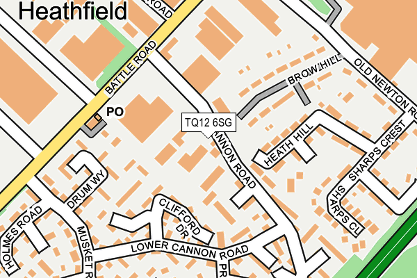
TQ12 6SG is located in the Bovey electoral ward, within the local authority district of Teignbridge and the English Parliamentary constituency of Central Devon. The Sub Integrated Care Board (ICB) Location is NHS Devon ICB - 15N and the police force is Devon & Cornwall. This postcode has been in use since December 2000.


GetTheData
Source: OS OpenMap – Local (Ordnance Survey)
Source: OS VectorMap District (Ordnance Survey)
Licence: Open Government Licence (requires attribution)
| Easting | 283022 |
| Northing | 75832 |
| Latitude | 50.570476 |
| Longitude | -3.653241 |
GetTheData
Source: Open Postcode Geo
Licence: Open Government Licence
| Country | England |
| Postcode District | TQ12 |
➜ See where TQ12 is on a map ➜ Where is Heathfield? | |
GetTheData
Source: Land Registry Price Paid Data
Licence: Open Government Licence
Elevation or altitude of TQ12 6SG as distance above sea level:
| Metres | Feet | |
|---|---|---|
| Elevation | 30m | 98ft |
Elevation is measured from the approximate centre of the postcode, to the nearest point on an OS contour line from OS Terrain 50, which has contour spacing of ten vertical metres.
➜ How high above sea level am I? Find the elevation of your current position using your device's GPS.
GetTheData
Source: Open Postcode Elevation
Licence: Open Government Licence
| Ward | Bovey |
| Constituency | Central Devon |
GetTheData
Source: ONS Postcode Database
Licence: Open Government Licence
| Cavalier Road (Battle Road) | Heathfield | 122m |
| Post Office (Battle Road) | Heathfield | 135m |
| Battle Road Top (Battle Road) | Heathfield | 223m |
| Battle Road Top (Battle Road) | Heathfield | 227m |
| Musket Road (Battle Road) | Heathfield | 268m |
| Newton Abbot Station | 5.9km |
GetTheData
Source: NaPTAN
Licence: Open Government Licence
GetTheData
Source: ONS Postcode Database
Licence: Open Government Licence


➜ Get more ratings from the Food Standards Agency
GetTheData
Source: Food Standards Agency
Licence: FSA terms & conditions
| Last Collection | |||
|---|---|---|---|
| Location | Mon-Fri | Sat | Distance |
| Coombe Cross | 16:00 | 08:30 | 2,694m |
| Preston | 15:30 | 10:45 | 2,868m |
| East Street | 16:00 | 08:15 | 2,928m |
GetTheData
Source: Dracos
Licence: Creative Commons Attribution-ShareAlike
The below table lists the International Territorial Level (ITL) codes (formerly Nomenclature of Territorial Units for Statistics (NUTS) codes) and Local Administrative Units (LAU) codes for TQ12 6SG:
| ITL 1 Code | Name |
|---|---|
| TLK | South West (England) |
| ITL 2 Code | Name |
| TLK4 | Devon |
| ITL 3 Code | Name |
| TLK43 | Devon CC |
| LAU 1 Code | Name |
| E07000045 | Teignbridge |
GetTheData
Source: ONS Postcode Directory
Licence: Open Government Licence
The below table lists the Census Output Area (OA), Lower Layer Super Output Area (LSOA), and Middle Layer Super Output Area (MSOA) for TQ12 6SG:
| Code | Name | |
|---|---|---|
| OA | E00102333 | |
| LSOA | E01020204 | Teignbridge 007B |
| MSOA | E02004207 | Teignbridge 007 |
GetTheData
Source: ONS Postcode Directory
Licence: Open Government Licence
| TQ12 6RP | Drum Way | 116m |
| TQ12 6GX | Clifford Drive | 125m |
| TQ12 6TD | Oliver Place | 141m |
| TQ12 6RJ | Drum Way | 142m |
| TQ12 6SP | Heath Hill | 151m |
| TQ12 6SW | Browhill | 167m |
| TQ12 6SH | Cannon Road | 168m |
| TQ12 6RY | Battle Road | 171m |
| TQ12 6TN | Battle Road | 172m |
| TQ12 6SU | Lower Cannon Road | 187m |
GetTheData
Source: Open Postcode Geo; Land Registry Price Paid Data
Licence: Open Government Licence