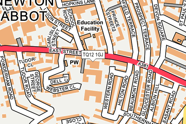
TQ12 1GJ lies on Scott Close in Newton Abbot. TQ12 1GJ is located in the College electoral ward, within the local authority district of Teignbridge and the English Parliamentary constituency of Newton Abbot. The Sub Integrated Care Board (ICB) Location is NHS Devon ICB - 15N and the police force is Devon & Cornwall. This postcode has been in use since August 2013.


GetTheData
Source: OS OpenMap – Local (Ordnance Survey)
Source: OS VectorMap District (Ordnance Survey)
Licence: Open Government Licence (requires attribution)
| Easting | 286140 |
| Northing | 71112 |
| Latitude | 50.528674 |
| Longitude | -3.607771 |
GetTheData
Source: Open Postcode Geo
Licence: Open Government Licence
| Street | Scott Close |
| Town/City | Newton Abbot |
| Country | England |
| Postcode District | TQ12 |
➜ See where TQ12 is on a map ➜ Where is Newton Abbot? | |
GetTheData
Source: Land Registry Price Paid Data
Licence: Open Government Licence
Elevation or altitude of TQ12 1GJ as distance above sea level:
| Metres | Feet | |
|---|---|---|
| Elevation | 10m | 33ft |
Elevation is measured from the approximate centre of the postcode, to the nearest point on an OS contour line from OS Terrain 50, which has contour spacing of ten vertical metres.
➜ How high above sea level am I? Find the elevation of your current position using your device's GPS.
GetTheData
Source: Open Postcode Elevation
Licence: Open Government Licence
| Ward | College |
| Constituency | Newton Abbot |
GetTheData
Source: ONS Postcode Database
Licence: Open Government Licence
| Queen Street | Newton Abbot | 231m |
| Post Office (Queen Street) | Newton Abbot | 338m |
| Sherborne Road | Newton Abbot | 350m |
| Sherborne Road | Newton Abbot | 354m |
| Sherborne Road | Newton Abbot | 354m |
| Newton Abbot Station | 0.6km |
GetTheData
Source: NaPTAN
Licence: Open Government Licence
GetTheData
Source: ONS Postcode Database
Licence: Open Government Licence


➜ Get more ratings from the Food Standards Agency
GetTheData
Source: Food Standards Agency
Licence: FSA terms & conditions
| Last Collection | |||
|---|---|---|---|
| Location | Mon-Fri | Sat | Distance |
| East Street | 17:30 | 12:30 | 44m |
| Queen Street | 17:30 | 12:15 | 240m |
| Courtenay St | 18:30 | 251m | |
GetTheData
Source: Dracos
Licence: Creative Commons Attribution-ShareAlike
The below table lists the International Territorial Level (ITL) codes (formerly Nomenclature of Territorial Units for Statistics (NUTS) codes) and Local Administrative Units (LAU) codes for TQ12 1GJ:
| ITL 1 Code | Name |
|---|---|
| TLK | South West (England) |
| ITL 2 Code | Name |
| TLK4 | Devon |
| ITL 3 Code | Name |
| TLK43 | Devon CC |
| LAU 1 Code | Name |
| E07000045 | Teignbridge |
GetTheData
Source: ONS Postcode Directory
Licence: Open Government Licence
The below table lists the Census Output Area (OA), Lower Layer Super Output Area (LSOA), and Middle Layer Super Output Area (MSOA) for TQ12 1GJ:
| Code | Name | |
|---|---|---|
| OA | E00102438 | |
| LSOA | E01020226 | Teignbridge 015C |
| MSOA | E02004215 | Teignbridge 015 |
GetTheData
Source: ONS Postcode Directory
Licence: Open Government Licence
| TQ12 1GH | East Street | 36m |
| TQ12 2LD | East Street | 39m |
| TQ12 1AQ | East Street | 64m |
| TQ12 1BG | Mapleton Place | 67m |
| TQ12 2LS | King Street | 72m |
| TQ12 2GG | King Street | 83m |
| TQ12 2JR | East Street | 84m |
| TQ12 1BD | Hampton Road | 92m |
| TQ12 2LQ | East Street | 104m |
| TQ12 2LB | Summerland Cottages | 106m |
GetTheData
Source: Open Postcode Geo; Land Registry Price Paid Data
Licence: Open Government Licence