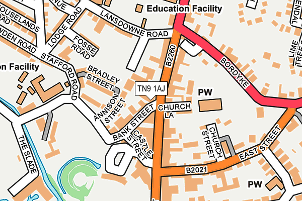
TN9 1AJ is located in the Judd electoral ward, within the local authority district of Tonbridge and Malling and the English Parliamentary constituency of Tonbridge and Malling. The Sub Integrated Care Board (ICB) Location is NHS Kent and Medway ICB - 91Q and the police force is Kent. This postcode has been in use since November 2010.


GetTheData
Source: OS OpenMap – Local (Ordnance Survey)
Source: OS VectorMap District (Ordnance Survey)
Licence: Open Government Licence (requires attribution)
| Easting | 559062 |
| Northing | 146751 |
| Latitude | 51.197836 |
| Longitude | 0.275225 |
GetTheData
Source: Open Postcode Geo
Licence: Open Government Licence
| Country | England |
| Postcode District | TN9 |
➜ See where TN9 is on a map ➜ Where is Tonbridge? | |
GetTheData
Source: Land Registry Price Paid Data
Licence: Open Government Licence
Elevation or altitude of TN9 1AJ as distance above sea level:
| Metres | Feet | |
|---|---|---|
| Elevation | 30m | 98ft |
Elevation is measured from the approximate centre of the postcode, to the nearest point on an OS contour line from OS Terrain 50, which has contour spacing of ten vertical metres.
➜ How high above sea level am I? Find the elevation of your current position using your device's GPS.
GetTheData
Source: Open Postcode Elevation
Licence: Open Government Licence
| Ward | Judd |
| Constituency | Tonbridge And Malling |
GetTheData
Source: ONS Postcode Database
Licence: Open Government Licence
| Castle (High Street) | Tonbridge | 129m |
| Castle (High Street) | Tonbridge | 149m |
| Bordyke | Tonbridge | 150m |
| Bordyke | Tonbridge | 159m |
| Castle (High Street) | Tonbridge | 177m |
| Tonbridge Station | 0.8km |
| Hildenborough Station | 3.8km |
| Leigh (Kent) Station | 4.5km |
GetTheData
Source: NaPTAN
Licence: Open Government Licence
GetTheData
Source: ONS Postcode Database
Licence: Open Government Licence


➜ Get more ratings from the Food Standards Agency
GetTheData
Source: Food Standards Agency
Licence: FSA terms & conditions
| Last Collection | |||
|---|---|---|---|
| Location | Mon-Fri | Sat | Distance |
| Tonbridge School | 18:45 | 12:45 | 298m |
| High Street | 18:45 | 12:30 | 358m |
| Lower High Street | 19:00 | 12:30 | 584m |
GetTheData
Source: Dracos
Licence: Creative Commons Attribution-ShareAlike
The below table lists the International Territorial Level (ITL) codes (formerly Nomenclature of Territorial Units for Statistics (NUTS) codes) and Local Administrative Units (LAU) codes for TN9 1AJ:
| ITL 1 Code | Name |
|---|---|
| TLJ | South East (England) |
| ITL 2 Code | Name |
| TLJ4 | Kent |
| ITL 3 Code | Name |
| TLJ46 | West Kent |
| LAU 1 Code | Name |
| E07000115 | Tonbridge and Malling |
GetTheData
Source: ONS Postcode Directory
Licence: Open Government Licence
The below table lists the Census Output Area (OA), Lower Layer Super Output Area (LSOA), and Middle Layer Super Output Area (MSOA) for TN9 1AJ:
| Code | Name | |
|---|---|---|
| OA | E00167636 | |
| LSOA | E01024732 | Tonbridge and Malling 012A |
| MSOA | E02005160 | Tonbridge and Malling 012 |
GetTheData
Source: ONS Postcode Directory
Licence: Open Government Licence
| TN9 1AF | High Street | 15m |
| TN9 1BL | Bank Street | 44m |
| TN9 1BU | Bank Street | 53m |
| TN9 1BS | Exchange Court | 57m |
| TN9 1FP | Jefferys Passage | 61m |
| TN9 1BB | High Street | 68m |
| TN9 1BX | High Street | 72m |
| TN9 1BF | Annison Street | 77m |
| TN9 1DH | High Street | 77m |
| TN9 1DA | Church Lane | 77m |
GetTheData
Source: Open Postcode Geo; Land Registry Price Paid Data
Licence: Open Government Licence