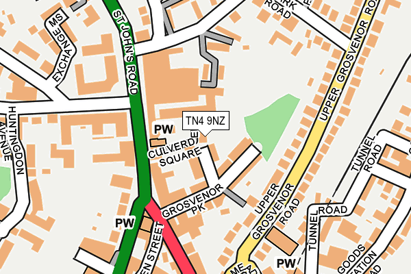
TN4 9NZ is located in the Culverden electoral ward, within the local authority district of Tunbridge Wells and the English Parliamentary constituency of Tunbridge Wells. The Sub Integrated Care Board (ICB) Location is NHS Kent and Medway ICB - 91Q and the police force is Kent. This postcode has been in use since October 2009.


GetTheData
Source: OS OpenMap – Local (Ordnance Survey)
Source: OS VectorMap District (Ordnance Survey)
Licence: Open Government Licence (requires attribution)
| Easting | 558411 |
| Northing | 140065 |
| Latitude | 51.137946 |
| Longitude | 0.262945 |
GetTheData
Source: Open Postcode Geo
Licence: Open Government Licence
| Country | England |
| Postcode District | TN4 |
➜ See where TN4 is on a map ➜ Where is Royal Tunbridge Wells? | |
GetTheData
Source: Land Registry Price Paid Data
Licence: Open Government Licence
Elevation or altitude of TN4 9NZ as distance above sea level:
| Metres | Feet | |
|---|---|---|
| Elevation | 120m | 394ft |
Elevation is measured from the approximate centre of the postcode, to the nearest point on an OS contour line from OS Terrain 50, which has contour spacing of ten vertical metres.
➜ How high above sea level am I? Find the elevation of your current position using your device's GPS.
GetTheData
Source: Open Postcode Elevation
Licence: Open Government Licence
| Ward | Culverden |
| Constituency | Tunbridge Wells |
GetTheData
Source: ONS Postcode Database
Licence: Open Government Licence
| London Road Arriva Depot (London Road) | St John's | 110m |
| London Road Arriva Depot (London Road) | St John's | 176m |
| Meadow Road | Tunbridge Wells | 206m |
| Grosvenor Road | Tunbridge Wells | 214m |
| Royal Wells Park (Mount Ephraim) | St John's | 219m |
| Tunbridge Wells Station | 0.9km |
| High Brooms Station | 1.6km |
| Frant Station | 4.4km |
GetTheData
Source: NaPTAN
Licence: Open Government Licence
GetTheData
Source: ONS Postcode Database
Licence: Open Government Licence


➜ Get more ratings from the Food Standards Agency
GetTheData
Source: Food Standards Agency
Licence: FSA terms & conditions
| Last Collection | |||
|---|---|---|---|
| Location | Mon-Fri | Sat | Distance |
| Culverden Park | 17:15 | 12:15 | 177m |
| Dudley Road | 18:45 | 12:00 | 291m |
| Goods Station Road | 17:30 | 12:15 | 299m |
GetTheData
Source: Dracos
Licence: Creative Commons Attribution-ShareAlike
The below table lists the International Territorial Level (ITL) codes (formerly Nomenclature of Territorial Units for Statistics (NUTS) codes) and Local Administrative Units (LAU) codes for TN4 9NZ:
| ITL 1 Code | Name |
|---|---|
| TLJ | South East (England) |
| ITL 2 Code | Name |
| TLJ4 | Kent |
| ITL 3 Code | Name |
| TLJ46 | West Kent |
| LAU 1 Code | Name |
| E07000116 | Tunbridge Wells |
GetTheData
Source: ONS Postcode Directory
Licence: Open Government Licence
The below table lists the Census Output Area (OA), Lower Layer Super Output Area (LSOA), and Middle Layer Super Output Area (MSOA) for TN4 9NZ:
| Code | Name | |
|---|---|---|
| OA | E00125886 | |
| LSOA | E01024802 | Tunbridge Wells 008B |
| MSOA | E02005169 | Tunbridge Wells 008 |
GetTheData
Source: ONS Postcode Directory
Licence: Open Government Licence
| TN1 2BB | Grosvenor Park | 35m |
| TN4 9NS | Culverden Square | 43m |
| TN4 9NL | Shirley Cottages | 67m |
| TN4 9NT | St Johns Road | 76m |
| TN1 2BD | Grosvenor Park | 85m |
| TN4 9JS | Sandringham Mews | 88m |
| TN4 9NP | St Johns Road | 93m |
| TN4 9QW | St Johns Road | 97m |
| TN1 2DX | Upper Grosvenor Road | 114m |
| TN1 2BE | Grosvenor Walk | 117m |
GetTheData
Source: Open Postcode Geo; Land Registry Price Paid Data
Licence: Open Government Licence