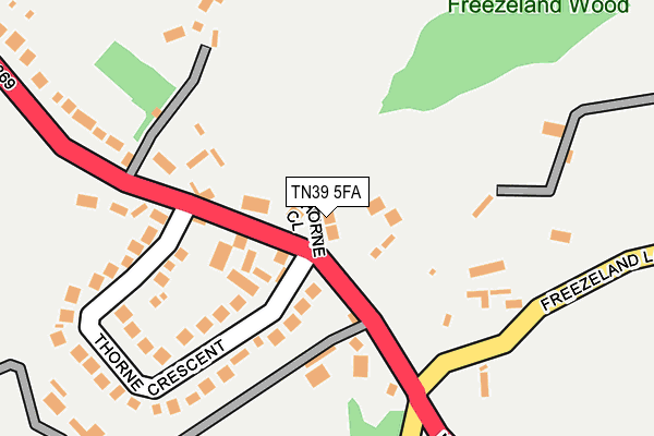
TN39 5FA is located in the Bexhill Sidley electoral ward, within the local authority district of Rother and the English Parliamentary constituency of Bexhill and Battle. The Sub Integrated Care Board (ICB) Location is NHS Sussex ICB - 97R and the police force is Sussex. This postcode has been in use since April 2017.


GetTheData
Source: OS OpenMap – Local (Ordnance Survey)
Source: OS VectorMap District (Ordnance Survey)
Licence: Open Government Licence (requires attribution)
| Easting | 572516 |
| Northing | 110386 |
| Latitude | 50.867234 |
| Longitude | 0.450307 |
GetTheData
Source: Open Postcode Geo
Licence: Open Government Licence
| Country | England |
| Postcode District | TN39 |
➜ See where TN39 is on a map | |
GetTheData
Source: Land Registry Price Paid Data
Licence: Open Government Licence
| Ward | Bexhill Sidley |
| Constituency | Bexhill And Battle |
GetTheData
Source: ONS Postcode Database
Licence: Open Government Licence
| St Mary's Lane (Ninfield Road) | Sidley | 107m |
| St Mary's Lane (Ninfield Road) | Sidley | 120m |
| Recreation Ground (Ninfield Road) | Sidley | 531m |
| Peartree Lane (Ninfield Road) | Lunsford's Cross | 545m |
| Peartree Lane (Ninfield Road) | Lunsford's Cross | 546m |
| Collington Station | 3.2km |
| Bexhill Station | 3.5km |
| Cooden Beach Station | 4.1km |
GetTheData
Source: NaPTAN
Licence: Open Government Licence
| Percentage of properties with Next Generation Access | 100.0% |
| Percentage of properties with Superfast Broadband | 100.0% |
| Percentage of properties with Ultrafast Broadband | 0.0% |
| Percentage of properties with Full Fibre Broadband | 0.0% |
Superfast Broadband is between 30Mbps and 300Mbps
Ultrafast Broadband is > 300Mbps
| Percentage of properties unable to receive 2Mbps | 0.0% |
| Percentage of properties unable to receive 5Mbps | 0.0% |
| Percentage of properties unable to receive 10Mbps | 0.0% |
| Percentage of properties unable to receive 30Mbps | 0.0% |
GetTheData
Source: Ofcom
Licence: Ofcom Terms of Use (requires attribution)
GetTheData
Source: ONS Postcode Database
Licence: Open Government Licence


➜ Get more ratings from the Food Standards Agency
GetTheData
Source: Food Standards Agency
Licence: FSA terms & conditions
| Last Collection | |||
|---|---|---|---|
| Location | Mon-Fri | Sat | Distance |
| Ninfield Road | 17:15 | 09:00 | 187m |
| Lunsford Cross | 17:15 | 09:00 | 561m |
| Mayo Lane | 17:15 | 12:15 | 1,118m |
GetTheData
Source: Dracos
Licence: Creative Commons Attribution-ShareAlike
The below table lists the International Territorial Level (ITL) codes (formerly Nomenclature of Territorial Units for Statistics (NUTS) codes) and Local Administrative Units (LAU) codes for TN39 5FA:
| ITL 1 Code | Name |
|---|---|
| TLJ | South East (England) |
| ITL 2 Code | Name |
| TLJ2 | Surrey, East and West Sussex |
| ITL 3 Code | Name |
| TLJ22 | East Sussex CC |
| LAU 1 Code | Name |
| E07000064 | Rother |
GetTheData
Source: ONS Postcode Directory
Licence: Open Government Licence
The below table lists the Census Output Area (OA), Lower Layer Super Output Area (LSOA), and Middle Layer Super Output Area (MSOA) for TN39 5FA:
| Code | Name | |
|---|---|---|
| OA | E00107370 | |
| LSOA | E01021138 | Rother 009G |
| MSOA | E02004400 | Rother 009 |
GetTheData
Source: ONS Postcode Directory
Licence: Open Government Licence
| TN39 5JG | Ninfield Road | 57m |
| TN39 5JH | Thorne Crescent | 174m |
| TN39 5JJ | Ninfield Road | 345m |
| TN39 5JE | St Marys Lane | 435m |
| TN39 5JD | Freezeland Lane | 439m |
| TN39 5DE | Ninfield Road | 563m |
| TN39 5JN | Peartree Lane | 642m |
| TN39 5JL | Potmans Lane | 711m |
| TN39 5DF | Beacon Hill | 801m |
| TN39 5DD | Ninfield Road | 809m |
GetTheData
Source: Open Postcode Geo; Land Registry Price Paid Data
Licence: Open Government Licence