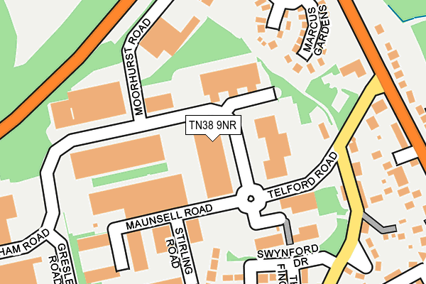
TN38 9NR is located in the Hollington electoral ward, within the local authority district of Hastings and the English Parliamentary constituency of Hastings and Rye. The Sub Integrated Care Board (ICB) Location is NHS Sussex ICB - 97R and the police force is Sussex. This postcode has been in use since January 1980.


GetTheData
Source: OS OpenMap – Local (Ordnance Survey)
Source: OS VectorMap District (Ordnance Survey)
Licence: Open Government Licence (requires attribution)
| Easting | 578935 |
| Northing | 112323 |
| Latitude | 50.882686 |
| Longitude | 0.542381 |
GetTheData
Source: Open Postcode Geo
Licence: Open Government Licence
| Country | England |
| Postcode District | TN38 |
➜ See where TN38 is on a map ➜ Where is Hastings? | |
GetTheData
Source: Land Registry Price Paid Data
Licence: Open Government Licence
Elevation or altitude of TN38 9NR as distance above sea level:
| Metres | Feet | |
|---|---|---|
| Elevation | 110m | 361ft |
Elevation is measured from the approximate centre of the postcode, to the nearest point on an OS contour line from OS Terrain 50, which has contour spacing of ten vertical metres.
➜ How high above sea level am I? Find the elevation of your current position using your device's GPS.
GetTheData
Source: Open Postcode Elevation
Licence: Open Government Licence
| Ward | Hollington |
| Constituency | Hastings And Rye |
GetTheData
Source: ONS Postcode Database
Licence: Open Government Licence
| Maunsell Road (Castleham Road) | Castleham Industrial Estate | 93m |
| Maunsell Road (Castleham Road) | Castleham Industrial Estate | 99m |
| Moorhurst Road (Castleham Road) | Castleham Industrial Estate | 100m |
| Moorhurst Road (Castleham Road) | Castleham Industrial Estate | 106m |
| Old Church Road (Telford Road) | Hollington | 160m |
| Crowhurst Station | 3km |
| St Leonards Warrior Square Station | 3.3km |
| West St Leonards Station | 3.3km |
GetTheData
Source: NaPTAN
Licence: Open Government Licence
Estimated total energy consumption in TN38 9NR by fuel type, 2015.
| Consumption (kWh) | 62,984 |
|---|---|
| Meter count | 6 |
| Mean (kWh/meter) | 10,497 |
| Median (kWh/meter) | 10,871 |
GetTheData
Source: Postcode level gas estimates: 2015 (experimental)
Source: Postcode level electricity estimates: 2015 (experimental)
Licence: Open Government Licence
GetTheData
Source: ONS Postcode Database
Licence: Open Government Licence


➜ Get more ratings from the Food Standards Agency
GetTheData
Source: Food Standards Agency
Licence: FSA terms & conditions
| Last Collection | |||
|---|---|---|---|
| Location | Mon-Fri | Sat | Distance |
| Telford Road | 18:45 | 12:00 | 92m |
| Telford Road Meterbox | 97m | ||
| Battle Road | 17:15 | 12:00 | 402m |
GetTheData
Source: Dracos
Licence: Creative Commons Attribution-ShareAlike
The below table lists the International Territorial Level (ITL) codes (formerly Nomenclature of Territorial Units for Statistics (NUTS) codes) and Local Administrative Units (LAU) codes for TN38 9NR:
| ITL 1 Code | Name |
|---|---|
| TLJ | South East (England) |
| ITL 2 Code | Name |
| TLJ2 | Surrey, East and West Sussex |
| ITL 3 Code | Name |
| TLJ22 | East Sussex CC |
| LAU 1 Code | Name |
| E07000062 | Hastings |
GetTheData
Source: ONS Postcode Directory
Licence: Open Government Licence
The below table lists the Census Output Area (OA), Lower Layer Super Output Area (LSOA), and Middle Layer Super Output Area (MSOA) for TN38 9NR:
| Code | Name | |
|---|---|---|
| OA | E00106613 | |
| LSOA | E01020994 | Hastings 003B |
| MSOA | E02004370 | Hastings 003 |
GetTheData
Source: ONS Postcode Directory
Licence: Open Government Licence
| TN38 9LY | Telford Road | 156m |
| TN38 9NQ | Swynford Drive | 164m |
| TN37 7NS | Carinus Gardens | 186m |
| TN38 9LT | Old Church Road | 191m |
| TN38 9NE | Swynford Drive | 197m |
| TN37 7NW | Marcus Gardens | 207m |
| TN38 9LR | Old Church Road | 214m |
| TN38 9LW | The Kestrels | 230m |
| TN38 9LQ | The Finches | 232m |
| TN38 9LU | Lancaster Road | 235m |
GetTheData
Source: Open Postcode Geo; Land Registry Price Paid Data
Licence: Open Government Licence