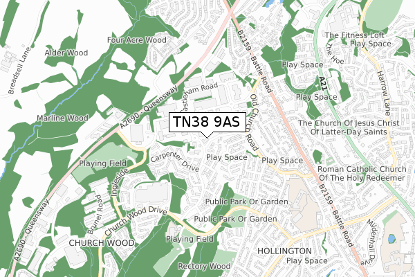
TN38 9AS is located in the Hollington electoral ward, within the local authority district of Hastings and the English Parliamentary constituency of Hastings and Rye. The Sub Integrated Care Board (ICB) Location is NHS Sussex ICB - 97R and the police force is Sussex. This postcode has been in use since January 2018.


GetTheData
Source: OS Open Zoomstack (Ordnance Survey)
Licence: Open Government Licence (requires attribution)
Attribution: Contains OS data © Crown copyright and database right 2024
Source: Open Postcode Geo
Licence: Open Government Licence (requires attribution)
Attribution: Contains OS data © Crown copyright and database right 2024; Contains Royal Mail data © Royal Mail copyright and database right 2024; Source: Office for National Statistics licensed under the Open Government Licence v.3.0
| Easting | 578831 |
| Northing | 112037 |
| Latitude | 50.880149 |
| Longitude | 0.540765 |
GetTheData
Source: Open Postcode Geo
Licence: Open Government Licence
| Country | England |
| Postcode District | TN38 |
➜ See where TN38 is on a map ➜ Where is Hastings? | |
GetTheData
Source: Land Registry Price Paid Data
Licence: Open Government Licence
| Ward | Hollington |
| Constituency | Hastings And Rye |
GetTheData
Source: ONS Postcode Database
Licence: Open Government Licence
| Lancaster Road West (Gresley Road) | Castleham Industrial Estate | 28m |
| Stanier Road (Gresley Road) | Castleham Industrial Estate | 103m |
| Carpenter Drive (Tile Barn Road) | Hollington | 200m |
| Carpenter Drive (Tile Barn Road) | Hollington | 215m |
| Vg Scienta (Castleham Road) | Castleham Industrial Estate | 227m |
| Crowhurst Station | 2.9km |
| West St Leonards Station | 3km |
| St Leonards Warrior Square Station | 3km |
GetTheData
Source: NaPTAN
Licence: Open Government Licence
| Percentage of properties with Next Generation Access | 100.0% |
| Percentage of properties with Superfast Broadband | 100.0% |
| Percentage of properties with Ultrafast Broadband | 0.0% |
| Percentage of properties with Full Fibre Broadband | 0.0% |
Superfast Broadband is between 30Mbps and 300Mbps
Ultrafast Broadband is > 300Mbps
| Median download speed | 22.5Mbps |
| Average download speed | 29.5Mbps |
| Maximum download speed | 67.97Mbps |
| Median upload speed | 1.1Mbps |
| Average upload speed | 4.1Mbps |
| Maximum upload speed | 19.87Mbps |
| Percentage of properties unable to receive 2Mbps | 0.0% |
| Percentage of properties unable to receive 5Mbps | 0.0% |
| Percentage of properties unable to receive 10Mbps | 0.0% |
| Percentage of properties unable to receive 30Mbps | 0.0% |
GetTheData
Source: Ofcom
Licence: Ofcom Terms of Use (requires attribution)
GetTheData
Source: ONS Postcode Database
Licence: Open Government Licence


➜ Get more ratings from the Food Standards Agency
GetTheData
Source: Food Standards Agency
Licence: FSA terms & conditions
| Last Collection | |||
|---|---|---|---|
| Location | Mon-Fri | Sat | Distance |
| Tilebarn Road | 17:30 | 12:00 | 264m |
| Telford Road | 18:45 | 12:00 | 289m |
| Telford Road Meterbox | 293m | ||
GetTheData
Source: Dracos
Licence: Creative Commons Attribution-ShareAlike
The below table lists the International Territorial Level (ITL) codes (formerly Nomenclature of Territorial Units for Statistics (NUTS) codes) and Local Administrative Units (LAU) codes for TN38 9AS:
| ITL 1 Code | Name |
|---|---|
| TLJ | South East (England) |
| ITL 2 Code | Name |
| TLJ2 | Surrey, East and West Sussex |
| ITL 3 Code | Name |
| TLJ22 | East Sussex CC |
| LAU 1 Code | Name |
| E07000062 | Hastings |
GetTheData
Source: ONS Postcode Directory
Licence: Open Government Licence
The below table lists the Census Output Area (OA), Lower Layer Super Output Area (LSOA), and Middle Layer Super Output Area (MSOA) for TN38 9AS:
| Code | Name | |
|---|---|---|
| OA | E00106610 | |
| LSOA | E01020994 | Hastings 003B |
| MSOA | E02004370 | Hastings 003 |
GetTheData
Source: ONS Postcode Directory
Licence: Open Government Licence
| TN38 9BP | Beecham Place | 81m |
| TN38 9LU | Lancaster Road | 105m |
| TN38 9NQ | Swynford Drive | 158m |
| TN38 9LW | The Kestrels | 158m |
| TN38 9RU | Taylor Close | 163m |
| TN38 9QP | Norfolk Drive | 173m |
| TN38 9QW | Adam Close | 185m |
| TN38 9QN | Northampton Way | 192m |
| TN38 9RX | Carpenter Drive | 204m |
| TN38 9SB | Carpenter Drive | 205m |
GetTheData
Source: Open Postcode Geo; Land Registry Price Paid Data
Licence: Open Government Licence