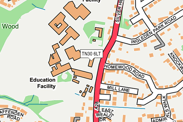
TN30 6LT is located in the Tenterden North electoral ward, within the local authority district of Ashford and the English Parliamentary constituency of Ashford. The Sub Integrated Care Board (ICB) Location is NHS Kent and Medway ICB - 91Q and the police force is Kent. This postcode has been in use since January 1980.


GetTheData
Source: OS OpenMap – Local (Ordnance Survey)
Source: OS VectorMap District (Ordnance Survey)
Licence: Open Government Licence (requires attribution)
| Easting | 588805 |
| Northing | 134276 |
| Latitude | 51.076742 |
| Longitude | 0.693896 |
GetTheData
Source: Open Postcode Geo
Licence: Open Government Licence
| Country | England |
| Postcode District | TN30 |
➜ See where TN30 is on a map ➜ Where is Tenterden? | |
GetTheData
Source: Land Registry Price Paid Data
Licence: Open Government Licence
Elevation or altitude of TN30 6LT as distance above sea level:
| Metres | Feet | |
|---|---|---|
| Elevation | 60m | 197ft |
Elevation is measured from the approximate centre of the postcode, to the nearest point on an OS contour line from OS Terrain 50, which has contour spacing of ten vertical metres.
➜ How high above sea level am I? Find the elevation of your current position using your device's GPS.
GetTheData
Source: Open Postcode Elevation
Licence: Open Government Licence
| Ward | Tenterden North |
| Constituency | Ashford |
GetTheData
Source: ONS Postcode Database
Licence: Open Government Licence
| Homewood School (Ashford Road) | Tenterden | 44m |
| Homewood School (Ashford Road) | Tenterden | 58m |
| Homewood School Grounds | Tenterden | 208m |
| Fat Ox (Silver Hill) | Tenterden | 270m |
| Turners Avenue (Ashford Road) | Tenterden | 316m |
| Tenterden Town Rail Station (Kesr) | Tenterden | 952m |
GetTheData
Source: NaPTAN
Licence: Open Government Licence
GetTheData
Source: ONS Postcode Database
Licence: Open Government Licence


➜ Get more ratings from the Food Standards Agency
GetTheData
Source: Food Standards Agency
Licence: FSA terms & conditions
| Last Collection | |||
|---|---|---|---|
| Location | Mon-Fri | Sat | Distance |
| Henley Meadows | 16:30 | 09:00 | 446m |
| Tenterden Sorting Office | 17:30 | 11:30 | 669m |
| Railway Station | 16:00 | 10:00 | 977m |
GetTheData
Source: Dracos
Licence: Creative Commons Attribution-ShareAlike
The below table lists the International Territorial Level (ITL) codes (formerly Nomenclature of Territorial Units for Statistics (NUTS) codes) and Local Administrative Units (LAU) codes for TN30 6LT:
| ITL 1 Code | Name |
|---|---|
| TLJ | South East (England) |
| ITL 2 Code | Name |
| TLJ4 | Kent |
| ITL 3 Code | Name |
| TLJ45 | Mid Kent |
| LAU 1 Code | Name |
| E07000105 | Ashford |
GetTheData
Source: ONS Postcode Directory
Licence: Open Government Licence
The below table lists the Census Output Area (OA), Lower Layer Super Output Area (LSOA), and Middle Layer Super Output Area (MSOA) for TN30 6LT:
| Code | Name | |
|---|---|---|
| OA | E00121969 | |
| LSOA | E01024024 | Ashford 013E |
| MSOA | E02005008 | Ashford 013 |
GetTheData
Source: ONS Postcode Directory
Licence: Open Government Licence
| TN30 6LU | Ashford Road | 62m |
| TN30 6NB | April Cottage | 65m |
| TN30 6NA | Mill Lane | 111m |
| TN30 6ND | Ashford Road | 134m |
| TN30 6LY | Adams Close | 143m |
| TN30 6LX | Ashford Road | 164m |
| TN30 6NE | Silver Hill | 172m |
| TN30 7AW | Goldsmith Court | 179m |
| TN30 6NR | Ingleden Park Road | 185m |
| TN30 7AU | Homewood Road | 189m |
GetTheData
Source: Open Postcode Geo; Land Registry Price Paid Data
Licence: Open Government Licence