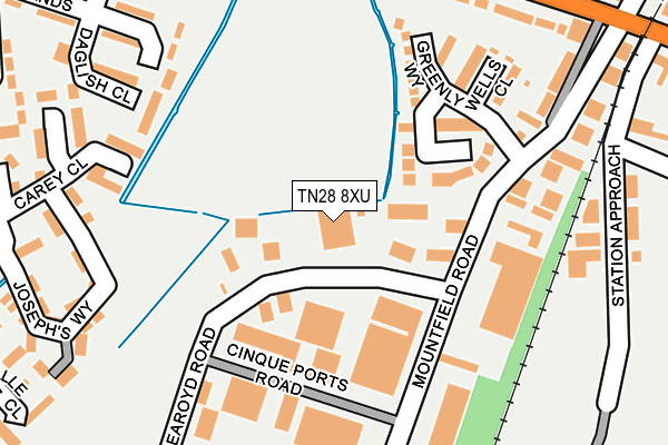
TN28 8XU is located in the New Romney electoral ward, within the local authority district of Folkestone and Hythe and the English Parliamentary constituency of Folkestone and Hythe. The Sub Integrated Care Board (ICB) Location is NHS Kent and Medway ICB - 91Q and the police force is Kent. This postcode has been in use since January 1991.


GetTheData
Source: OS OpenMap – Local (Ordnance Survey)
Source: OS VectorMap District (Ordnance Survey)
Licence: Open Government Licence (requires attribution)
| Easting | 607124 |
| Northing | 124644 |
| Latitude | 50.983930 |
| Longitude | 0.949553 |
GetTheData
Source: Open Postcode Geo
Licence: Open Government Licence
| Country | England |
| Postcode District | TN28 |
➜ See where TN28 is on a map ➜ Where is New Romney? | |
GetTheData
Source: Land Registry Price Paid Data
Licence: Open Government Licence
Elevation or altitude of TN28 8XU as distance above sea level:
| Metres | Feet | |
|---|---|---|
| Elevation | 0m | 0ft |
Elevation is measured from the approximate centre of the postcode, to the nearest point on an OS contour line from OS Terrain 50, which has contour spacing of ten vertical metres.
➜ How high above sea level am I? Find the elevation of your current position using your device's GPS.
GetTheData
Source: Open Postcode Elevation
Licence: Open Government Licence
| Ward | New Romney |
| Constituency | Folkestone And Hythe |
GetTheData
Source: ONS Postcode Database
Licence: Open Government Licence
| Greenly Way (Mountfield Road) | New Romney | 147m |
| Greenly Way (Mountfield Road) | New Romney | 237m |
| Collins Road | New Romney | 254m |
| Light Railway Station (Littlestone Road) | New Romney | 362m |
| Light Railway Station (Littlestone Road) | New Romney | 364m |
| New Romney Station (Rhdr) | New Romney | 348m |
GetTheData
Source: NaPTAN
Licence: Open Government Licence
Estimated total energy consumption in TN28 8XU by fuel type, 2015.
| Consumption (kWh) | 95,911 |
|---|---|
| Meter count | 8 |
| Mean (kWh/meter) | 11,989 |
| Median (kWh/meter) | 7,822 |
GetTheData
Source: Postcode level gas estimates: 2015 (experimental)
Source: Postcode level electricity estimates: 2015 (experimental)
Licence: Open Government Licence
GetTheData
Source: ONS Postcode Database
Licence: Open Government Licence

➜ Get more ratings from the Food Standards Agency
GetTheData
Source: Food Standards Agency
Licence: FSA terms & conditions
| Last Collection | |||
|---|---|---|---|
| Location | Mon-Fri | Sat | Distance |
| New Romney Post Office | 17:15 | 11:45 | 798m |
| Gordons Villas | 17:00 | 09:00 | 1,195m |
| Littlestone Golf Club | 16:15 | 09:00 | 1,299m |
GetTheData
Source: Dracos
Licence: Creative Commons Attribution-ShareAlike
The below table lists the International Territorial Level (ITL) codes (formerly Nomenclature of Territorial Units for Statistics (NUTS) codes) and Local Administrative Units (LAU) codes for TN28 8XU:
| ITL 1 Code | Name |
|---|---|
| TLJ | South East (England) |
| ITL 2 Code | Name |
| TLJ4 | Kent |
| ITL 3 Code | Name |
| TLJ44 | East Kent |
| LAU 1 Code | Name |
| E07000112 | Folkestone and Hythe |
GetTheData
Source: ONS Postcode Directory
Licence: Open Government Licence
The below table lists the Census Output Area (OA), Lower Layer Super Output Area (LSOA), and Middle Layer Super Output Area (MSOA) for TN28 8XU:
| Code | Name | |
|---|---|---|
| OA | E00124558 | |
| LSOA | E01024539 | Shepway 012C |
| MSOA | E02005113 | Shepway 012 |
GetTheData
Source: ONS Postcode Directory
Licence: Open Government Licence
| TN28 8US | The Meadows | 108m |
| TN28 8XP | Imbert Close | 122m |
| TN28 8XW | Greenly Way | 145m |
| TN28 8LH | Mountfield Road | 164m |
| TN28 8XR | Greenly Way | 167m |
| TN28 8AN | Cinque Ports Road | 177m |
| TN28 8XS | Wells Close | 186m |
| TN28 8LQ | Station Road | 220m |
| TN28 8XF | Daglish Close | 239m |
| TN28 8LD | The Churchlands | 241m |
GetTheData
Source: Open Postcode Geo; Land Registry Price Paid Data
Licence: Open Government Licence