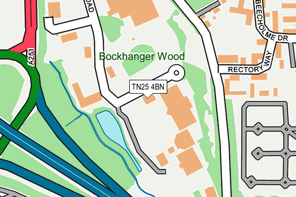
TN25 4BN is located in the Bockhanger electoral ward, within the local authority district of Ashford and the English Parliamentary constituency of Ashford. The Sub Integrated Care Board (ICB) Location is NHS Kent and Medway ICB - 91Q and the police force is Kent. This postcode has been in use since December 1999.


GetTheData
Source: OS OpenMap – Local (Ordnance Survey)
Source: OS VectorMap District (Ordnance Survey)
Licence: Open Government Licence (requires attribution)
| Easting | 600962 |
| Northing | 144107 |
| Latitude | 51.160907 |
| Longitude | 0.872690 |
GetTheData
Source: Open Postcode Geo
Licence: Open Government Licence
| Country | England |
| Postcode District | TN25 |
➜ See where TN25 is on a map ➜ Where is Ashford? | |
GetTheData
Source: Land Registry Price Paid Data
Licence: Open Government Licence
Elevation or altitude of TN25 4BN as distance above sea level:
| Metres | Feet | |
|---|---|---|
| Elevation | 40m | 131ft |
Elevation is measured from the approximate centre of the postcode, to the nearest point on an OS contour line from OS Terrain 50, which has contour spacing of ten vertical metres.
➜ How high above sea level am I? Find the elevation of your current position using your device's GPS.
GetTheData
Source: Open Postcode Elevation
Licence: Open Government Licence
| Ward | Bockhanger |
| Constituency | Ashford |
GetTheData
Source: ONS Postcode Database
Licence: Open Government Licence
| Cineworld (Rutherford Road) | Eureka Park | 17m |
| Sainsbury's (Car Park) | Ashford | 363m |
| Thomson Road (Trinity Road) | Eureka Park | 448m |
| Warren Retail Park (Simone Weil Avenue) | Ashford | 450m |
| Warren Retail Park (Simone Weil Avenue) | Ashford | 454m |
| Ashford International Station | 1.9km |
| Wye Station | 4.8km |
GetTheData
Source: NaPTAN
Licence: Open Government Licence
| Median download speed | 40.0Mbps |
| Average download speed | 38.2Mbps |
| Maximum download speed | 80.00Mbps |
| Median upload speed | 10.0Mbps |
| Average upload speed | 9.0Mbps |
| Maximum upload speed | 20.00Mbps |
GetTheData
Source: Ofcom
Licence: Ofcom Terms of Use (requires attribution)
GetTheData
Source: ONS Postcode Database
Licence: Open Government Licence


➜ Get more ratings from the Food Standards Agency
GetTheData
Source: Food Standards Agency
Licence: FSA terms & conditions
| Last Collection | |||
|---|---|---|---|
| Location | Mon-Fri | Sat | Distance |
| Beecholme Drive | 17:00 | 11:45 | 268m |
| Quantock Drive | 17:45 | 11:45 | 576m |
| Bybrook Road | 17:00 | 11:45 | 576m |
GetTheData
Source: Dracos
Licence: Creative Commons Attribution-ShareAlike
The below table lists the International Territorial Level (ITL) codes (formerly Nomenclature of Territorial Units for Statistics (NUTS) codes) and Local Administrative Units (LAU) codes for TN25 4BN:
| ITL 1 Code | Name |
|---|---|
| TLJ | South East (England) |
| ITL 2 Code | Name |
| TLJ4 | Kent |
| ITL 3 Code | Name |
| TLJ45 | Mid Kent |
| LAU 1 Code | Name |
| E07000105 | Ashford |
GetTheData
Source: ONS Postcode Directory
Licence: Open Government Licence
The below table lists the Census Output Area (OA), Lower Layer Super Output Area (LSOA), and Middle Layer Super Output Area (MSOA) for TN25 4BN:
| Code | Name | |
|---|---|---|
| OA | E00121756 | |
| LSOA | E01023981 | Ashford 004B |
| MSOA | E02004999 | Ashford 004 |
GetTheData
Source: ONS Postcode Directory
Licence: Open Government Licence
| TN24 9EQ | Cemetery Lane | 199m |
| TN24 9RE | Rectory Way | 216m |
| TN24 8XH | Warren Retail Park | 318m |
| TN24 9AA | Beecholme Drive | 344m |
| TN24 9RA | Mardol Road | 356m |
| TN24 9JW | Nine Acres | 382m |
| TN24 9JS | Nine Acres | 384m |
| TN24 9BX | Beecholme Drive | 418m |
| TN24 9BZ | Beecholme Drive | 425m |
| TN24 9JR | Nine Acres | 435m |
GetTheData
Source: Open Postcode Geo; Land Registry Price Paid Data
Licence: Open Government Licence