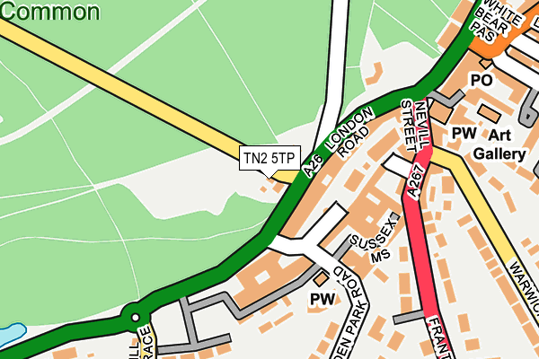
TN2 5TP lies on Major Yorks Road in Tunbridge Wells. TN2 5TP is located in the Broadwater electoral ward, within the local authority district of Tunbridge Wells and the English Parliamentary constituency of Tunbridge Wells. The Sub Integrated Care Board (ICB) Location is NHS Kent and Medway ICB - 91Q and the police force is Kent. This postcode has been in use since January 1980.


GetTheData
Source: OS OpenMap – Local (Ordnance Survey)
Source: OS VectorMap District (Ordnance Survey)
Licence: Open Government Licence (requires attribution)
| Easting | 558009 |
| Northing | 138733 |
| Latitude | 51.126089 |
| Longitude | 0.256620 |
GetTheData
Source: Open Postcode Geo
Licence: Open Government Licence
| Street | Major Yorks Road |
| Town/City | Tunbridge Wells |
| Country | England |
| Postcode District | TN2 |
➜ See where TN2 is on a map ➜ Where is Royal Tunbridge Wells? | |
GetTheData
Source: Land Registry Price Paid Data
Licence: Open Government Licence
Elevation or altitude of TN2 5TP as distance above sea level:
| Metres | Feet | |
|---|---|---|
| Elevation | 90m | 295ft |
Elevation is measured from the approximate centre of the postcode, to the nearest point on an OS contour line from OS Terrain 50, which has contour spacing of ten vertical metres.
➜ How high above sea level am I? Find the elevation of your current position using your device's GPS.
GetTheData
Source: Open Postcode Elevation
Licence: Open Government Licence
| Ward | Broadwater |
| Constituency | Tunbridge Wells |
GetTheData
Source: ONS Postcode Database
Licence: Open Government Licence
YORK COTTAGE, MAJOR YORKS ROAD, TUNBRIDGE WELLS, TN2 5TP 2006 22 AUG £360,000 |
YORK COTTAGE, MAJOR YORKS ROAD, TUNBRIDGE WELLS, TN2 5TP 2004 27 AUG £320,000 |
➜ Royal Tunbridge Wells house prices
GetTheData
Source: HM Land Registry Price Paid Data
Licence: Contains HM Land Registry data © Crown copyright and database right 2024. This data is licensed under the Open Government Licence v3.0.
| The Pantiles (Eridge Road) | Tunbridge Wells | 48m |
| The Pantiles (Eridge Road) | Tunbridge Wells | 59m |
| Chapel Place (London Road) | Tunbridge Wells | 227m |
| Chapel Place (London Road) | Tunbridge Wells | 243m |
| Old West Station Sainsbury's (Linden Park Road) | Showfields | 289m |
| Tunbridge Wells West (Spa Valley Railway) | Showfields | 377m |
| Tunbridge Wells Station | 0.6km |
| High Brooms Station | 3km |
| Frant Station | 3.6km |
GetTheData
Source: NaPTAN
Licence: Open Government Licence
GetTheData
Source: ONS Postcode Database
Licence: Open Government Licence


➜ Get more ratings from the Food Standards Agency
GetTheData
Source: Food Standards Agency
Licence: FSA terms & conditions
| Last Collection | |||
|---|---|---|---|
| Location | Mon-Fri | Sat | Distance |
| The Pantiles Post Office | 17:30 | 12:00 | 88m |
| Central Station | 18:00 | 12:00 | 373m |
| High Street | 18:45 | 12:00 | 387m |
GetTheData
Source: Dracos
Licence: Creative Commons Attribution-ShareAlike
The below table lists the International Territorial Level (ITL) codes (formerly Nomenclature of Territorial Units for Statistics (NUTS) codes) and Local Administrative Units (LAU) codes for TN2 5TP:
| ITL 1 Code | Name |
|---|---|
| TLJ | South East (England) |
| ITL 2 Code | Name |
| TLJ4 | Kent |
| ITL 3 Code | Name |
| TLJ46 | West Kent |
| LAU 1 Code | Name |
| E07000116 | Tunbridge Wells |
GetTheData
Source: ONS Postcode Directory
Licence: Open Government Licence
The below table lists the Census Output Area (OA), Lower Layer Super Output Area (LSOA), and Middle Layer Super Output Area (MSOA) for TN2 5TP:
| Code | Name | |
|---|---|---|
| OA | E00125863 | |
| LSOA | E01024796 | Tunbridge Wells 010B |
| MSOA | E02005171 | Tunbridge Wells 010 |
GetTheData
Source: ONS Postcode Directory
Licence: Open Government Licence
| TN2 5TW | The Pantiles | 48m |
| TN2 5TN | The Pantiles | 76m |
| TN2 5TE | The Pantiles | 96m |
| TN2 5BF | London Road | 115m |
| TN2 5TD | The Pantiles | 129m |
| TN2 5SQ | Market Street | 142m |
| TN2 5QJ | Sussex Mews | 146m |
| TN2 5SA | Nevill Street | 147m |
| TN2 5QZ | Linden Park Road | 153m |
| TN4 8HH | Linden Close | 164m |
GetTheData
Source: Open Postcode Geo; Land Registry Price Paid Data
Licence: Open Government Licence