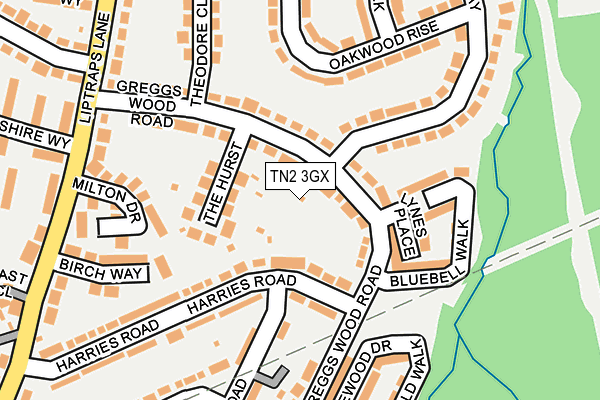
TN2 3GX is located in the Sherwood electoral ward, within the local authority district of Tunbridge Wells and the English Parliamentary constituency of Tunbridge Wells. The Sub Integrated Care Board (ICB) Location is NHS Kent and Medway ICB - 91Q and the police force is Kent. This postcode has been in use since March 2017.


GetTheData
Source: OS OpenMap – Local (Ordnance Survey)
Source: OS VectorMap District (Ordnance Survey)
Licence: Open Government Licence (requires attribution)
| Easting | 559784 |
| Northing | 140556 |
| Latitude | 51.141974 |
| Longitude | 0.282798 |
GetTheData
Source: Open Postcode Geo
Licence: Open Government Licence
| Country | England |
| Postcode District | TN2 |
➜ See where TN2 is on a map ➜ Where is Royal Tunbridge Wells? | |
GetTheData
Source: Land Registry Price Paid Data
Licence: Open Government Licence
| Ward | Sherwood |
| Constituency | Tunbridge Wells |
GetTheData
Source: ONS Postcode Database
Licence: Open Government Licence
| Woodview (Ferndale) | Tunbridge Wells | 241m |
| Woodview (Ferndale) | Tunbridge Wells | 252m |
| Medical Centre (Greggs Wood Road) | Sherwood | 258m |
| Lipscombe Road (Ravenswood Avenue) | Tunbridge Wells | 260m |
| Coneyburrow Road (Sherwood Road) | Sherwood | 264m |
| High Brooms Station | 0.9km |
| Tunbridge Wells Station | 1.9km |
| Frant Station | 4.3km |
GetTheData
Source: NaPTAN
Licence: Open Government Licence
| Percentage of properties with Next Generation Access | 100.0% |
| Percentage of properties with Superfast Broadband | 100.0% |
| Percentage of properties with Ultrafast Broadband | 0.0% |
| Percentage of properties with Full Fibre Broadband | 0.0% |
Superfast Broadband is between 30Mbps and 300Mbps
Ultrafast Broadband is > 300Mbps
| Percentage of properties unable to receive 2Mbps | 0.0% |
| Percentage of properties unable to receive 5Mbps | 0.0% |
| Percentage of properties unable to receive 10Mbps | 0.0% |
| Percentage of properties unable to receive 30Mbps | 0.0% |
GetTheData
Source: Ofcom
Licence: Ofcom Terms of Use (requires attribution)
GetTheData
Source: ONS Postcode Database
Licence: Open Government Licence


➜ Get more ratings from the Food Standards Agency
GetTheData
Source: Food Standards Agency
Licence: FSA terms & conditions
| Last Collection | |||
|---|---|---|---|
| Location | Mon-Fri | Sat | Distance |
| Hilbert Road | 17:30 | 12:00 | 520m |
| Cleveland | 17:30 | 12:00 | 748m |
| Salisbury Gardens | 17:30 | 12:00 | 806m |
GetTheData
Source: Dracos
Licence: Creative Commons Attribution-ShareAlike
The below table lists the International Territorial Level (ITL) codes (formerly Nomenclature of Territorial Units for Statistics (NUTS) codes) and Local Administrative Units (LAU) codes for TN2 3GX:
| ITL 1 Code | Name |
|---|---|
| TLJ | South East (England) |
| ITL 2 Code | Name |
| TLJ4 | Kent |
| ITL 3 Code | Name |
| TLJ46 | West Kent |
| LAU 1 Code | Name |
| E07000116 | Tunbridge Wells |
GetTheData
Source: ONS Postcode Directory
Licence: Open Government Licence
The below table lists the Census Output Area (OA), Lower Layer Super Output Area (LSOA), and Middle Layer Super Output Area (MSOA) for TN2 3GX:
| Code | Name | |
|---|---|---|
| OA | E00126100 | |
| LSOA | E01024842 | Tunbridge Wells 005C |
| MSOA | E02005166 | Tunbridge Wells 005 |
GetTheData
Source: ONS Postcode Directory
Licence: Open Government Licence
| TN2 3JU | Sandhurst Road | 74m |
| TN2 3NX | Cedar Ridge | 74m |
| TN2 3JX | Sandhurst Road | 102m |
| TN2 3LG | Sherwood Road | 114m |
| TN2 3LA | High Beeches | 123m |
| TN2 3LB | Sherwood Road | 150m |
| TN2 3NZ | Springhead | 154m |
| TN2 3LL | Sherwood Way | 154m |
| TN2 3SQ | Ravenswood Avenue | 182m |
| TN2 3NT | Ferndale | 182m |
GetTheData
Source: Open Postcode Geo; Land Registry Price Paid Data
Licence: Open Government Licence