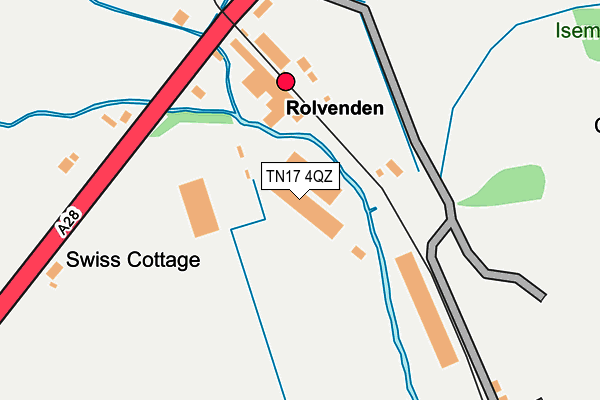
TN17 4QZ is located in the Rolvenden & Tenterden West electoral ward, within the local authority district of Ashford and the English Parliamentary constituency of Ashford. The Sub Integrated Care Board (ICB) Location is NHS Kent and Medway ICB - 91Q and the police force is Kent. This postcode has been in use since June 1999.


GetTheData
Source: OS OpenMap – Local (Ordnance Survey)
Source: OS VectorMap District (Ordnance Survey)
Licence: Open Government Licence (requires attribution)
| Easting | 586522 |
| Northing | 132629 |
| Latitude | 51.062694 |
| Longitude | 0.660494 |
GetTheData
Source: Open Postcode Geo
Licence: Open Government Licence
| Country | England |
| Postcode District | TN17 |
➜ See where TN17 is on a map | |
GetTheData
Source: Land Registry Price Paid Data
Licence: Open Government Licence
Elevation or altitude of TN17 4QZ as distance above sea level:
| Metres | Feet | |
|---|---|---|
| Elevation | 10m | 33ft |
Elevation is measured from the approximate centre of the postcode, to the nearest point on an OS contour line from OS Terrain 50, which has contour spacing of ten vertical metres.
➜ How high above sea level am I? Find the elevation of your current position using your device's GPS.
GetTheData
Source: Open Postcode Elevation
Licence: Open Government Licence
| Ward | Rolvenden & Tenterden West |
| Constituency | Ashford |
GetTheData
Source: ONS Postcode Database
Licence: Open Government Licence
| Kesr Station (Rolvenden Road) | Rolvenden | 166m |
| Kesr Station (Rolvenden Road) | Rolvenden | 178m |
| The Bungalows (Rolvenden Hill) | Rolvenden | 357m |
| The Bungalows (Rolvenden Hill) | Rolvenden | 365m |
| Esso Garage (Rolvenden Road) | Tenterden | 662m |
| Rolvenden Rail Station (Kesr) | Rolvenden | 219m |
GetTheData
Source: NaPTAN
Licence: Open Government Licence
GetTheData
Source: ONS Postcode Database
Licence: Open Government Licence


➜ Get more ratings from the Food Standards Agency
GetTheData
Source: Food Standards Agency
Licence: FSA terms & conditions
| Last Collection | |||
|---|---|---|---|
| Location | Mon-Fri | Sat | Distance |
| The Hill | 16:15 | 10:00 | 503m |
| Tenterden Post Office | 17:15 | 11:15 | 1,757m |
| Railway Station | 16:00 | 10:00 | 1,893m |
GetTheData
Source: Dracos
Licence: Creative Commons Attribution-ShareAlike
| Risk of TN17 4QZ flooding from rivers and sea | Medium |
| ➜ TN17 4QZ flood map | |
GetTheData
Source: Open Flood Risk by Postcode
Licence: Open Government Licence
The below table lists the International Territorial Level (ITL) codes (formerly Nomenclature of Territorial Units for Statistics (NUTS) codes) and Local Administrative Units (LAU) codes for TN17 4QZ:
| ITL 1 Code | Name |
|---|---|
| TLJ | South East (England) |
| ITL 2 Code | Name |
| TLJ4 | Kent |
| ITL 3 Code | Name |
| TLJ45 | Mid Kent |
| LAU 1 Code | Name |
| E07000105 | Ashford |
GetTheData
Source: ONS Postcode Directory
Licence: Open Government Licence
The below table lists the Census Output Area (OA), Lower Layer Super Output Area (LSOA), and Middle Layer Super Output Area (MSOA) for TN17 4QZ:
| Code | Name | |
|---|---|---|
| OA | E00121892 | |
| LSOA | E01024009 | Ashford 013A |
| MSOA | E02005008 | Ashford 013 |
GetTheData
Source: ONS Postcode Directory
Licence: Open Government Licence
| TN17 4JP | Tenterden Road | 193m |
| TN30 6UE | Rolvenden Road | 332m |
| TN17 4JN | Rolvenden Hill | 389m |
| TN30 6UD | Rolvenden Road | 469m |
| TN17 4JS | Puddingcake Lane | 620m |
| TN30 6UB | Rolvenden Road | 664m |
| TN30 6UA | Rolvenden Road | 745m |
| TN30 6TU | Plummer Lane | 931m |
| TN17 4JL | Tenterden Road | 945m |
| TN30 6TY | Rolvenden Road | 1049m |
GetTheData
Source: Open Postcode Geo; Land Registry Price Paid Data
Licence: Open Government Licence