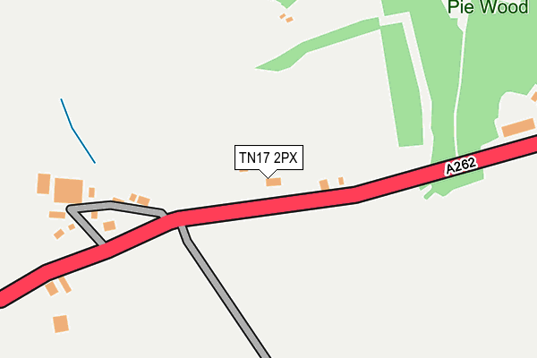
TN17 2PX lies on Goudhurst Road in Cranbrook. TN17 2PX is located in the Benenden and Cranbrook electoral ward, within the local authority district of Tunbridge Wells and the English Parliamentary constituency of Maidstone and The Weald. The Sub Integrated Care Board (ICB) Location is NHS Kent and Medway ICB - 91Q and the police force is Kent. This postcode has been in use since January 1980.


GetTheData
Source: OS OpenMap – Local (Ordnance Survey)
Source: OS VectorMap District (Ordnance Survey)
Licence: Open Government Licence (requires attribution)
| Easting | 576067 |
| Northing | 137737 |
| Latitude | 51.111880 |
| Longitude | 0.513936 |
GetTheData
Source: Open Postcode Geo
Licence: Open Government Licence
| Street | Goudhurst Road |
| Town/City | Cranbrook |
| Country | England |
| Postcode District | TN17 |
➜ See where TN17 is on a map | |
GetTheData
Source: Land Registry Price Paid Data
Licence: Open Government Licence
Elevation or altitude of TN17 2PX as distance above sea level:
| Metres | Feet | |
|---|---|---|
| Elevation | 80m | 262ft |
Elevation is measured from the approximate centre of the postcode, to the nearest point on an OS contour line from OS Terrain 50, which has contour spacing of ten vertical metres.
➜ How high above sea level am I? Find the elevation of your current position using your device's GPS.
GetTheData
Source: Open Postcode Elevation
Licence: Open Government Licence
| Ward | Benenden And Cranbrook |
| Constituency | Maidstone And The Weald |
GetTheData
Source: ONS Postcode Database
Licence: Open Government Licence
| Chalk Lane (A262) | Flishinghurst | 359m |
| Chalk Lane (A262) | Flishinghurst | 362m |
| The Peacock (Cranbrook Road) | Iden Green | 1,379m |
| The Peacock (Cranbrook Road) | Iden Green | 1,397m |
| High Weald Academy (Angley Road) | Cranbrook | 1,706m |
GetTheData
Source: NaPTAN
Licence: Open Government Licence
| Percentage of properties with Next Generation Access | 100.0% |
| Percentage of properties with Superfast Broadband | 66.7% |
| Percentage of properties with Ultrafast Broadband | 0.0% |
| Percentage of properties with Full Fibre Broadband | 0.0% |
Superfast Broadband is between 30Mbps and 300Mbps
Ultrafast Broadband is > 300Mbps
| Percentage of properties unable to receive 2Mbps | 0.0% |
| Percentage of properties unable to receive 5Mbps | 33.3% |
| Percentage of properties unable to receive 10Mbps | 33.3% |
| Percentage of properties unable to receive 30Mbps | 33.3% |
GetTheData
Source: Ofcom
Licence: Ofcom Terms of Use (requires attribution)
GetTheData
Source: ONS Postcode Database
Licence: Open Government Licence


➜ Get more ratings from the Food Standards Agency
GetTheData
Source: Food Standards Agency
Licence: FSA terms & conditions
| Last Collection | |||
|---|---|---|---|
| Location | Mon-Fri | Sat | Distance |
| Colliers Green | 16:00 | 09:00 | 1,085m |
| Friezley Lane | 16:00 | 09:00 | 1,286m |
| Glassenbury | 17:00 | 09:00 | 1,593m |
GetTheData
Source: Dracos
Licence: Creative Commons Attribution-ShareAlike
The below table lists the International Territorial Level (ITL) codes (formerly Nomenclature of Territorial Units for Statistics (NUTS) codes) and Local Administrative Units (LAU) codes for TN17 2PX:
| ITL 1 Code | Name |
|---|---|
| TLJ | South East (England) |
| ITL 2 Code | Name |
| TLJ4 | Kent |
| ITL 3 Code | Name |
| TLJ46 | West Kent |
| LAU 1 Code | Name |
| E07000116 | Tunbridge Wells |
GetTheData
Source: ONS Postcode Directory
Licence: Open Government Licence
The below table lists the Census Output Area (OA), Lower Layer Super Output Area (LSOA), and Middle Layer Super Output Area (MSOA) for TN17 2PX:
| Code | Name | |
|---|---|---|
| OA | E00125832 | |
| LSOA | E01024787 | Tunbridge Wells 013A |
| MSOA | E02005174 | Tunbridge Wells 013 |
GetTheData
Source: ONS Postcode Directory
Licence: Open Government Licence
| TN17 2PZ | Goudhurst Road | 187m |
| TN17 2QA | Goudhurst Road | 407m |
| TN17 2QB | Chalk Lane | 558m |
| TN17 2PT | Goudhurst Road | 586m |
| TN17 2QD | Goudhurst Road | 797m |
| TN17 2LR | 895m | |
| TN17 2LP | Marden Road | 920m |
| TN17 2PB | Goudhurst Road | 1398m |
| TN17 2QE | Glassenbury Road | 1423m |
| TN17 2PS | Goudhurst Road | 1459m |
GetTheData
Source: Open Postcode Geo; Land Registry Price Paid Data
Licence: Open Government Licence