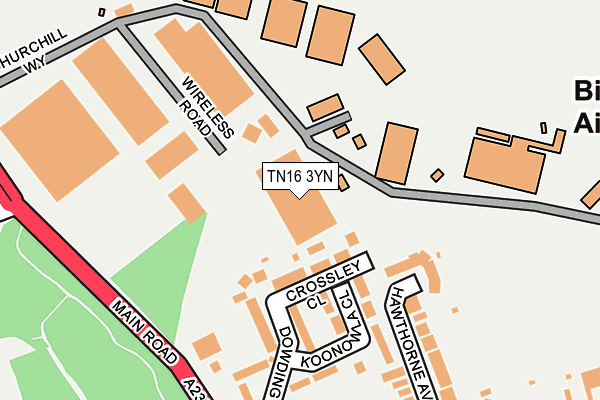
TN16 3YN is located in the Biggin Hill electoral ward, within the London borough of Bromley and the English Parliamentary constituency of Orpington. The Sub Integrated Care Board (ICB) Location is NHS South East London ICB - 72Q and the police force is Metropolitan Police. This postcode has been in use since August 1992.


GetTheData
Source: OS OpenMap – Local (Ordnance Survey)
Source: OS VectorMap District (Ordnance Survey)
Licence: Open Government Licence (requires attribution)
| Easting | 541821 |
| Northing | 159770 |
| Latitude | 51.319366 |
| Longitude | 0.033797 |
GetTheData
Source: Open Postcode Geo
Licence: Open Government Licence
| Country | England |
| Postcode District | TN16 |
➜ See where TN16 is on a map ➜ Where is Biggin Hill? | |
GetTheData
Source: Land Registry Price Paid Data
Licence: Open Government Licence
Elevation or altitude of TN16 3YN as distance above sea level:
| Metres | Feet | |
|---|---|---|
| Elevation | 190m | 623ft |
Elevation is measured from the approximate centre of the postcode, to the nearest point on an OS contour line from OS Terrain 50, which has contour spacing of ten vertical metres.
➜ How high above sea level am I? Find the elevation of your current position using your device's GPS.
GetTheData
Source: Open Postcode Elevation
Licence: Open Government Licence
| Ward | Biggin Hill |
| Constituency | Orpington |
GetTheData
Source: ONS Postcode Database
Licence: Open Government Licence
| Hawthorne Avenue (Jail Lane) | Biggin Hill | 273m |
| Hawthorne Avenue (Jail Lane) | Biggin Hill | 282m |
| Biggin Hill Black Horse (Main Road) | Biggin Hill | 344m |
| Biggin Hill Black Horse (Main Road) | Biggin Hill | 362m |
| Main Road Sunningvale Ave (Main Road) | Biggin Hill | 516m |
GetTheData
Source: NaPTAN
Licence: Open Government Licence
Estimated total energy consumption in TN16 3YN by fuel type, 2015.
| Consumption (kWh) | 237,013 |
|---|---|
| Meter count | 7 |
| Mean (kWh/meter) | 33,859 |
| Median (kWh/meter) | 39,407 |
GetTheData
Source: Postcode level gas estimates: 2015 (experimental)
Source: Postcode level electricity estimates: 2015 (experimental)
Licence: Open Government Licence
GetTheData
Source: ONS Postcode Database
Licence: Open Government Licence


➜ Get more ratings from the Food Standards Agency
GetTheData
Source: Food Standards Agency
Licence: FSA terms & conditions
| Last Collection | |||
|---|---|---|---|
| Location | Mon-Fri | Sat | Distance |
| Biggin Hill Green | 17:45 | 09:45 | 292m |
| Christy Road | 17:15 | 11:15 | 480m |
| Biggin Hill Sorting Office | 18:15 | 09:30 | 578m |
GetTheData
Source: Dracos
Licence: Creative Commons Attribution-ShareAlike
The below table lists the International Territorial Level (ITL) codes (formerly Nomenclature of Territorial Units for Statistics (NUTS) codes) and Local Administrative Units (LAU) codes for TN16 3YN:
| ITL 1 Code | Name |
|---|---|
| TLI | London |
| ITL 2 Code | Name |
| TLI6 | Outer London - South |
| ITL 3 Code | Name |
| TLI61 | Bromley |
| LAU 1 Code | Name |
| E09000006 | Bromley |
GetTheData
Source: ONS Postcode Directory
Licence: Open Government Licence
The below table lists the Census Output Area (OA), Lower Layer Super Output Area (LSOA), and Middle Layer Super Output Area (MSOA) for TN16 3YN:
| Code | Name | |
|---|---|---|
| OA | E00003183 | |
| LSOA | E01000658 | Bromley 042A |
| MSOA | E02006789 | Bromley 042 |
GetTheData
Source: ONS Postcode Directory
Licence: Open Government Licence
| TN16 3BL | Crossley Close | 72m |
| TN16 3BG | Dowding Road | 119m |
| TN16 3BJ | Koonowla Close | 135m |
| TN16 3BW | Airport Industrial Estate | 172m |
| TN16 3SG | Hawthorne Avenue | 178m |
| TN16 3PS | Wireless Road | 213m |
| TN16 3BN | Churchill Way | 213m |
| TN16 3BE | Dowding Road | 227m |
| TN16 3SA | Jail Lane | 295m |
| TN16 3SJ | Magnolia Drive | 328m |
GetTheData
Source: Open Postcode Geo; Land Registry Price Paid Data
Licence: Open Government Licence