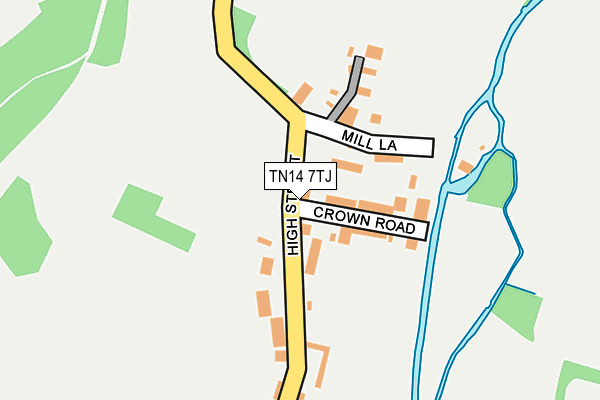
TN14 7TJ is located in the Otford and Shoreham electoral ward, within the local authority district of Sevenoaks and the English Parliamentary constituency of Sevenoaks. The Sub Integrated Care Board (ICB) Location is NHS Kent and Medway ICB - 91Q and the police force is Kent. This postcode has been in use since January 1980.


GetTheData
Source: OS OpenMap – Local (Ordnance Survey)
Source: OS VectorMap District (Ordnance Survey)
Licence: Open Government Licence (requires attribution)
| Easting | 551836 |
| Northing | 162078 |
| Latitude | 51.337521 |
| Longitude | 0.178360 |
GetTheData
Source: Open Postcode Geo
Licence: Open Government Licence
| Country | England |
| Postcode District | TN14 |
➜ See where TN14 is on a map ➜ Where is Shoreham? | |
GetTheData
Source: Land Registry Price Paid Data
Licence: Open Government Licence
Elevation or altitude of TN14 7TJ as distance above sea level:
| Metres | Feet | |
|---|---|---|
| Elevation | 60m | 197ft |
Elevation is measured from the approximate centre of the postcode, to the nearest point on an OS contour line from OS Terrain 50, which has contour spacing of ten vertical metres.
➜ How high above sea level am I? Find the elevation of your current position using your device's GPS.
GetTheData
Source: Open Postcode Elevation
Licence: Open Government Licence
| Ward | Otford And Shoreham |
| Constituency | Sevenoaks |
GetTheData
Source: ONS Postcode Database
Licence: Open Government Licence
| Post Office (High Street) | Shoreham | 219m |
| Church Street (Filston Lane) | Shoreham | 507m |
| Church Street (Filston Lane) | Shoreham | 515m |
| Railway Station (Station Forecourt) | Shoreham | 1,005m |
| Railway Station (A225) | Shoreham | 1,009m |
| Shoreham (Kent) Station | 0.9km |
| Otford Station | 3km |
| Eynsford Station | 3.3km |
GetTheData
Source: NaPTAN
Licence: Open Government Licence
GetTheData
Source: ONS Postcode Database
Licence: Open Government Licence


➜ Get more ratings from the Food Standards Agency
GetTheData
Source: Food Standards Agency
Licence: FSA terms & conditions
| Last Collection | |||
|---|---|---|---|
| Location | Mon-Fri | Sat | Distance |
| Papermills | 16:45 | 09:45 | 68m |
| Shoreham Post Office | 17:00 | 10:45 | 257m |
| Church Street | 17:00 | 09:00 | 480m |
GetTheData
Source: Dracos
Licence: Creative Commons Attribution-ShareAlike
The below table lists the International Territorial Level (ITL) codes (formerly Nomenclature of Territorial Units for Statistics (NUTS) codes) and Local Administrative Units (LAU) codes for TN14 7TJ:
| ITL 1 Code | Name |
|---|---|
| TLJ | South East (England) |
| ITL 2 Code | Name |
| TLJ4 | Kent |
| ITL 3 Code | Name |
| TLJ46 | West Kent |
| LAU 1 Code | Name |
| E07000111 | Sevenoaks |
GetTheData
Source: ONS Postcode Directory
Licence: Open Government Licence
The below table lists the Census Output Area (OA), Lower Layer Super Output Area (LSOA), and Middle Layer Super Output Area (MSOA) for TN14 7TJ:
| Code | Name | |
|---|---|---|
| OA | E00124129 | |
| LSOA | E01024452 | Sevenoaks 008E |
| MSOA | E02005094 | Sevenoaks 008 |
GetTheData
Source: ONS Postcode Directory
Licence: Open Government Licence
| TN14 7TN | Crown Road | 62m |
| TN14 7TE | High Street | 72m |
| TN14 7TL | Crown Road | 79m |
| TN14 7TS | Mill Lane | 93m |
| TN14 7TW | Riverdale Cottages | 120m |
| TN14 7TP | Mill Lane | 125m |
| TN14 7TG | Forge Way | 243m |
| TN14 7TB | High Street | 255m |
| TN14 7TH | Palmers Orchard | 301m |
| TN14 7TD | High Street | 377m |
GetTheData
Source: Open Postcode Geo; Land Registry Price Paid Data
Licence: Open Government Licence