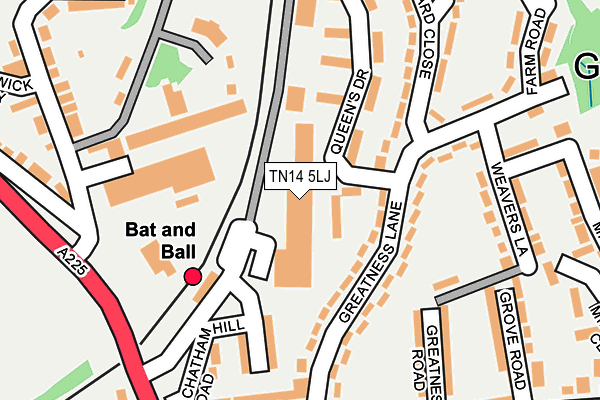
TN14 5LJ is located in the Sevenoaks Northern electoral ward, within the local authority district of Sevenoaks and the English Parliamentary constituency of Sevenoaks. The Sub Integrated Care Board (ICB) Location is NHS Kent and Medway ICB - 91Q and the police force is Kent. This postcode has been in use since December 1998.


GetTheData
Source: OS OpenMap – Local (Ordnance Survey)
Source: OS VectorMap District (Ordnance Survey)
Licence: Open Government Licence (requires attribution)
| Easting | 553187 |
| Northing | 156915 |
| Latitude | 51.290768 |
| Longitude | 0.195551 |
GetTheData
Source: Open Postcode Geo
Licence: Open Government Licence
| Country | England |
| Postcode District | TN14 |
➜ See where TN14 is on a map ➜ Where is Sevenoaks? | |
GetTheData
Source: Land Registry Price Paid Data
Licence: Open Government Licence
Elevation or altitude of TN14 5LJ as distance above sea level:
| Metres | Feet | |
|---|---|---|
| Elevation | 70m | 230ft |
Elevation is measured from the approximate centre of the postcode, to the nearest point on an OS contour line from OS Terrain 50, which has contour spacing of ten vertical metres.
➜ How high above sea level am I? Find the elevation of your current position using your device's GPS.
GetTheData
Source: Open Postcode Elevation
Licence: Open Government Licence
| Ward | Sevenoaks Northern |
| Constituency | Sevenoaks |
GetTheData
Source: ONS Postcode Database
Licence: Open Government Licence
| Queen's Drive (Greatness Lane) | Greatness | 89m |
| Queen's Drive (Greatness Lane) | Greatness | 108m |
| Bat And Ball Railway Station (Bat And Ball Road) | Bat & Ball | 149m |
| Weavers Lane | Greatness | 198m |
| Weavers Lane (Mill Lane) | Greatness | 214m |
| Bat & Ball Station | 0.1km |
| Sevenoaks Station | 1.8km |
| Dunton Green Station | 1.8km |
GetTheData
Source: NaPTAN
Licence: Open Government Licence
GetTheData
Source: ONS Postcode Database
Licence: Open Government Licence


➜ Get more ratings from the Food Standards Agency
GetTheData
Source: Food Standards Agency
Licence: FSA terms & conditions
| Last Collection | |||
|---|---|---|---|
| Location | Mon-Fri | Sat | Distance |
| Lower St Johns Post Office | 18:30 | 12:00 | 220m |
| Gas Works | 16:30 | 12:15 | 229m |
| Greatness | 17:00 | 12:15 | 243m |
GetTheData
Source: Dracos
Licence: Creative Commons Attribution-ShareAlike
The below table lists the International Territorial Level (ITL) codes (formerly Nomenclature of Territorial Units for Statistics (NUTS) codes) and Local Administrative Units (LAU) codes for TN14 5LJ:
| ITL 1 Code | Name |
|---|---|
| TLJ | South East (England) |
| ITL 2 Code | Name |
| TLJ4 | Kent |
| ITL 3 Code | Name |
| TLJ46 | West Kent |
| LAU 1 Code | Name |
| E07000111 | Sevenoaks |
GetTheData
Source: ONS Postcode Directory
Licence: Open Government Licence
The below table lists the Census Output Area (OA), Lower Layer Super Output Area (LSOA), and Middle Layer Super Output Area (MSOA) for TN14 5LJ:
| Code | Name | |
|---|---|---|
| OA | E00124188 | |
| LSOA | E01024465 | Sevenoaks 010D |
| MSOA | E02005096 | Sevenoaks 010 |
GetTheData
Source: ONS Postcode Directory
Licence: Open Government Licence
| TN14 5BD | Greatness Lane | 101m |
| TN14 5DB | Queens Drive | 116m |
| TN14 5BE | Greatness Lane | 132m |
| TN14 5DD | Queens Drive | 139m |
| TN14 5BG | Greatness Lane | 153m |
| TN14 5BH | Orchard Close | 188m |
| TN14 5AP | Chatham Hill Road | 202m |
| TN14 5BQ | Greatness Lane | 202m |
| TN14 5BY | Greatness Road | 219m |
| TN14 5BT | Weavers Lane | 224m |
GetTheData
Source: Open Postcode Geo; Land Registry Price Paid Data
Licence: Open Government Licence