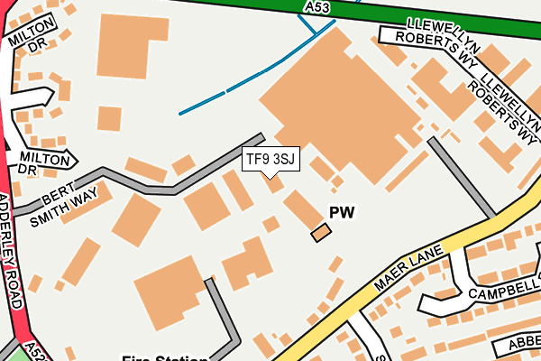
TF9 3SJ lies on Talbot Way in Market Drayton. TF9 3SJ is located in the Market Drayton East electoral ward, within the unitary authority of Shropshire and the English Parliamentary constituency of North Shropshire. The Sub Integrated Care Board (ICB) Location is NHS Shropshire, Telford and Wrekin ICB - M2L0M and the police force is West Mercia. This postcode has been in use since September 1991.


GetTheData
Source: OS OpenMap – Local (Ordnance Survey)
Source: OS VectorMap District (Ordnance Survey)
Licence: Open Government Licence (requires attribution)
| Easting | 367409 |
| Northing | 334874 |
| Latitude | 52.910313 |
| Longitude | -2.486061 |
GetTheData
Source: Open Postcode Geo
Licence: Open Government Licence
| Street | Talbot Way |
| Town/City | Market Drayton |
| Country | England |
| Postcode District | TF9 |
➜ See where TF9 is on a map ➜ Where is Market Drayton? | |
GetTheData
Source: Land Registry Price Paid Data
Licence: Open Government Licence
Elevation or altitude of TF9 3SJ as distance above sea level:
| Metres | Feet | |
|---|---|---|
| Elevation | 90m | 295ft |
Elevation is measured from the approximate centre of the postcode, to the nearest point on an OS contour line from OS Terrain 50, which has contour spacing of ten vertical metres.
➜ How high above sea level am I? Find the elevation of your current position using your device's GPS.
GetTheData
Source: Open Postcode Elevation
Licence: Open Government Licence
| Ward | Market Drayton East |
| Constituency | North Shropshire |
GetTheData
Source: ONS Postcode Database
Licence: Open Government Licence
STAARR HOUSE, TALBOT WAY, MARKET DRAYTON, TF9 3SJ 2001 31 DEC £185,000 |
GetTheData
Source: HM Land Registry Price Paid Data
Licence: Contains HM Land Registry data © Crown copyright and database right 2025. This data is licensed under the Open Government Licence v3.0.
| Cheshire Street Jct (Prospect Road) | Market Drayton | 371m |
| Hawthorn Way Jct (Rowan Road) | Market Drayton | 387m |
| Bus Station (Cheshire Street) | Market Drayton | 420m |
| Bus Station | Market Drayton | 425m |
| Bus Station | Market Drayton | 426m |
GetTheData
Source: NaPTAN
Licence: Open Government Licence
GetTheData
Source: ONS Postcode Database
Licence: Open Government Licence


➜ Get more ratings from the Food Standards Agency
GetTheData
Source: Food Standards Agency
Licence: FSA terms & conditions
| Last Collection | |||
|---|---|---|---|
| Location | Mon-Fri | Sat | Distance |
| Fairfields | 17:15 | 11:30 | 324m |
| Peatswood | 11:00 | 11:00 | 2,164m |
| Betton | 16:00 | 11:15 | 2,460m |
GetTheData
Source: Dracos
Licence: Creative Commons Attribution-ShareAlike
The below table lists the International Territorial Level (ITL) codes (formerly Nomenclature of Territorial Units for Statistics (NUTS) codes) and Local Administrative Units (LAU) codes for TF9 3SJ:
| ITL 1 Code | Name |
|---|---|
| TLG | West Midlands (England) |
| ITL 2 Code | Name |
| TLG2 | Shropshire and Staffordshire |
| ITL 3 Code | Name |
| TLG22 | Shropshire |
| LAU 1 Code | Name |
| E06000051 | Shropshire |
GetTheData
Source: ONS Postcode Directory
Licence: Open Government Licence
The below table lists the Census Output Area (OA), Lower Layer Super Output Area (LSOA), and Middle Layer Super Output Area (MSOA) for TF9 3SJ:
| Code | Name | |
|---|---|---|
| OA | E00147054 | |
| LSOA | E01028873 | Shropshire 005A |
| MSOA | E02006018 | Shropshire 005 |
GetTheData
Source: ONS Postcode Directory
Licence: Open Government Licence
| TF9 3AL | Maer Lane | 174m |
| TF9 1QX | Maer Lane | 180m |
| TF9 1QS | Maer Lane Industrial Estate | 232m |
| TF9 1QZ | Campbell Road | 262m |
| TF9 1EJ | Smithfield Road | 270m |
| TF9 1QY | Maer Lane | 291m |
| TF9 3SP | Milton Drive | 292m |
| TF9 3AH | Cheshire Street | 310m |
| TF9 3AA | Cheshire Street | 322m |
| TF9 1QG | Fairfields Road | 344m |
GetTheData
Source: Open Postcode Geo; Land Registry Price Paid Data
Licence: Open Government Licence