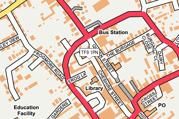
TF9 1PN lies on Cheshire Street in Market Drayton. TF9 1PN is located in the Market Drayton West electoral ward, within the unitary authority of Shropshire and the English Parliamentary constituency of North Shropshire. The Sub Integrated Care Board (ICB) Location is NHS Shropshire, Telford and Wrekin ICB - M2L0M and the police force is West Mercia. This postcode has been in use since January 1980.


GetTheData
Source: OS OpenMap – Local (Ordnance Survey)
Source: OS VectorMap District (Ordnance Survey)
Licence: Open Government Licence (requires attribution)
| Easting | 367400 |
| Northing | 334346 |
| Latitude | 52.905567 |
| Longitude | -2.486142 |
GetTheData
Source: Open Postcode Geo
Licence: Open Government Licence
| Street | Cheshire Street |
| Town/City | Market Drayton |
| Country | England |
| Postcode District | TF9 |
➜ See where TF9 is on a map ➜ Where is Market Drayton? | |
GetTheData
Source: Land Registry Price Paid Data
Licence: Open Government Licence
Elevation or altitude of TF9 1PN as distance above sea level:
| Metres | Feet | |
|---|---|---|
| Elevation | 90m | 295ft |
Elevation is measured from the approximate centre of the postcode, to the nearest point on an OS contour line from OS Terrain 50, which has contour spacing of ten vertical metres.
➜ How high above sea level am I? Find the elevation of your current position using your device's GPS.
GetTheData
Source: Open Postcode Elevation
Licence: Open Government Licence
| Ward | Market Drayton West |
| Constituency | North Shropshire |
GetTheData
Source: ONS Postcode Database
Licence: Open Government Licence
| Bus Station | Market Drayton | 101m |
| Bus Station | Market Drayton | 101m |
| Bus Station | Market Drayton | 102m |
| Iceland (Cheshire Street) | Market Drayton | 103m |
| Bus Station | Market Drayton | 103m |
GetTheData
Source: NaPTAN
Licence: Open Government Licence
| Median download speed | 19.1Mbps |
| Average download speed | 23.0Mbps |
| Maximum download speed | 55.00Mbps |
| Median upload speed | 1.2Mbps |
| Average upload speed | 6.6Mbps |
| Maximum upload speed | 20.00Mbps |
GetTheData
Source: Ofcom
Licence: Ofcom Terms of Use (requires attribution)
Estimated total energy consumption in TF9 1PN by fuel type, 2015.
| Consumption (kWh) | 114,511 |
|---|---|
| Meter count | 9 |
| Mean (kWh/meter) | 12,723 |
| Median (kWh/meter) | 5,962 |
GetTheData
Source: Postcode level gas estimates: 2015 (experimental)
Source: Postcode level electricity estimates: 2015 (experimental)
Licence: Open Government Licence
GetTheData
Source: ONS Postcode Database
Licence: Open Government Licence


➜ Get more ratings from the Food Standards Agency
GetTheData
Source: Food Standards Agency
Licence: FSA terms & conditions
| Last Collection | |||
|---|---|---|---|
| Location | Mon-Fri | Sat | Distance |
| Fairfields | 17:15 | 11:30 | 630m |
| Peatswood | 11:00 | 11:00 | 1,957m |
| Betton | 16:00 | 11:15 | 2,871m |
GetTheData
Source: Dracos
Licence: Creative Commons Attribution-ShareAlike
The below table lists the International Territorial Level (ITL) codes (formerly Nomenclature of Territorial Units for Statistics (NUTS) codes) and Local Administrative Units (LAU) codes for TF9 1PN:
| ITL 1 Code | Name |
|---|---|
| TLG | West Midlands (England) |
| ITL 2 Code | Name |
| TLG2 | Shropshire and Staffordshire |
| ITL 3 Code | Name |
| TLG22 | Shropshire |
| LAU 1 Code | Name |
| E06000051 | Shropshire |
GetTheData
Source: ONS Postcode Directory
Licence: Open Government Licence
The below table lists the Census Output Area (OA), Lower Layer Super Output Area (LSOA), and Middle Layer Super Output Area (MSOA) for TF9 1PN:
| Code | Name | |
|---|---|---|
| OA | E00147049 | |
| LSOA | E01028873 | Shropshire 005A |
| MSOA | E02006018 | Shropshire 005 |
GetTheData
Source: ONS Postcode Directory
Licence: Open Government Licence
| TF9 1PR | Cheshire Street | 28m |
| TF9 1PB | Mercian Court | 47m |
| TF9 1PS | Queen Street | 49m |
| TF9 3AF | Cheshire Street | 95m |
| TF9 3EB | Frogmore Road | 97m |
| TF9 1PH | Cheshire Street | 108m |
| TF9 3DE | Frogmore Place | 115m |
| TF9 3BU | Frogmore Road | 127m |
| TF9 3AU | Frogmore Road | 128m |
| TF9 1EQ | The Burgage | 147m |
GetTheData
Source: Open Postcode Geo; Land Registry Price Paid Data
Licence: Open Government Licence