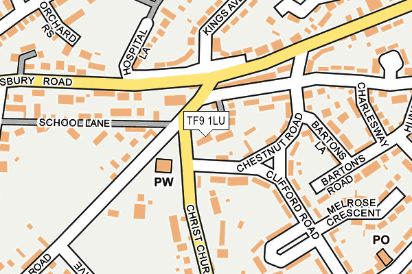
TF9 1LU lies on Buntingsdale Road in Market Drayton. TF9 1LU is located in the Market Drayton West electoral ward, within the unitary authority of Shropshire and the English Parliamentary constituency of North Shropshire. The Sub Integrated Care Board (ICB) Location is NHS Shropshire, Telford and Wrekin ICB - M2L0M and the police force is West Mercia. This postcode has been in use since January 1980.


GetTheData
Source: OS OpenMap – Local (Ordnance Survey)
Source: OS VectorMap District (Ordnance Survey)
Licence: Open Government Licence (requires attribution)
| Easting | 366391 |
| Northing | 333634 |
| Latitude | 52.899089 |
| Longitude | -2.501070 |
GetTheData
Source: Open Postcode Geo
Licence: Open Government Licence
| Street | Buntingsdale Road |
| Town/City | Market Drayton |
| Country | England |
| Postcode District | TF9 |
➜ See where TF9 is on a map ➜ Where is Market Drayton? | |
GetTheData
Source: Land Registry Price Paid Data
Licence: Open Government Licence
Elevation or altitude of TF9 1LU as distance above sea level:
| Metres | Feet | |
|---|---|---|
| Elevation | 90m | 295ft |
Elevation is measured from the approximate centre of the postcode, to the nearest point on an OS contour line from OS Terrain 50, which has contour spacing of ten vertical metres.
➜ How high above sea level am I? Find the elevation of your current position using your device's GPS.
GetTheData
Source: Open Postcode Elevation
Licence: Open Government Licence
| Ward | Market Drayton West |
| Constituency | North Shropshire |
GetTheData
Source: ONS Postcode Database
Licence: Open Government Licence
3, BUNTINGSDALE ROAD, MARKET DRAYTON, TF9 1LU 1996 5 NOV £60,000 |
GetTheData
Source: HM Land Registry Price Paid Data
Licence: Contains HM Land Registry data © Crown copyright and database right 2025. This data is licensed under the Open Government Licence v3.0.
| Kings Avenue Jct (Shrewsbury Road) | Market Drayton | 96m |
| Kings Avenue Jct (Shrewsbury Road) | Market Drayton | 105m |
| Melrose Crescent Jct (Clifford Road) | Market Drayton | 206m |
| Farcroft Drive Jct (Shrewsbury Road) | Market Drayton | 336m |
| Farcroft Drive Jct (Shrewsbury Road) | Market Drayton | 356m |
GetTheData
Source: NaPTAN
Licence: Open Government Licence
GetTheData
Source: ONS Postcode Database
Licence: Open Government Licence


➜ Get more ratings from the Food Standards Agency
GetTheData
Source: Food Standards Agency
Licence: FSA terms & conditions
| Last Collection | |||
|---|---|---|---|
| Location | Mon-Fri | Sat | Distance |
| Fairfields | 17:15 | 11:30 | 1,832m |
| Peatswood | 11:00 | 11:00 | 2,884m |
| Longslow Road | 17:00 | 11:30 | 3,071m |
GetTheData
Source: Dracos
Licence: Creative Commons Attribution-ShareAlike
The below table lists the International Territorial Level (ITL) codes (formerly Nomenclature of Territorial Units for Statistics (NUTS) codes) and Local Administrative Units (LAU) codes for TF9 1LU:
| ITL 1 Code | Name |
|---|---|
| TLG | West Midlands (England) |
| ITL 2 Code | Name |
| TLG2 | Shropshire and Staffordshire |
| ITL 3 Code | Name |
| TLG22 | Shropshire |
| LAU 1 Code | Name |
| E06000051 | Shropshire |
GetTheData
Source: ONS Postcode Directory
Licence: Open Government Licence
The below table lists the Census Output Area (OA), Lower Layer Super Output Area (LSOA), and Middle Layer Super Output Area (MSOA) for TF9 1LU:
| Code | Name | |
|---|---|---|
| OA | E00147079 | |
| LSOA | E01028879 | Shropshire 005G |
| MSOA | E02006018 | Shropshire 005 |
GetTheData
Source: ONS Postcode Directory
Licence: Open Government Licence
| TF9 1PT | Holly Drive | 53m |
| TF9 1LY | Chestnut Road | 66m |
| TF9 1BZ | Salisbury Road | 93m |
| TF9 3EH | Shrewsbury Road | 133m |
| TF9 3EW | Shrewsbury Road | 137m |
| TF9 1LT | Buntingsdale Road | 145m |
| TF9 3EJ | Shrewsbury Road | 148m |
| TF9 1DZ | Christchurch Lane | 154m |
| TF9 3BT | Hospital Lane | 158m |
| TF9 1NA | Clifford Road | 174m |
GetTheData
Source: Open Postcode Geo; Land Registry Price Paid Data
Licence: Open Government Licence