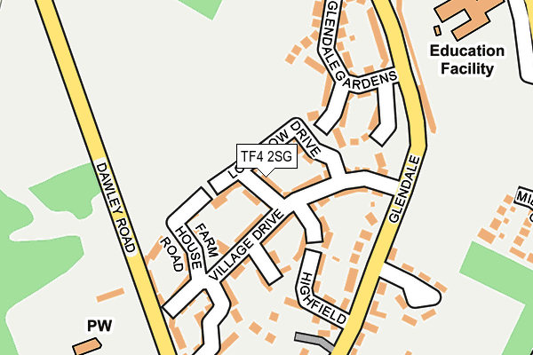
TF4 2SG is located in the Lawley electoral ward, within the unitary authority of Telford and Wrekin and the English Parliamentary constituency of Telford. The Sub Integrated Care Board (ICB) Location is NHS Shropshire, Telford and Wrekin ICB - M2L0M and the police force is West Mercia. This postcode has been in use since September 2016.


GetTheData
Source: OS OpenMap – Local (Ordnance Survey)
Source: OS VectorMap District (Ordnance Survey)
Licence: Open Government Licence (requires attribution)
| Easting | 366937 |
| Northing | 308904 |
| Latitude | 52.676836 |
| Longitude | -2.490444 |
GetTheData
Source: Open Postcode Geo
Licence: Open Government Licence
| Country | England |
| Postcode District | TF4 |
➜ See where TF4 is on a map | |
GetTheData
Source: Land Registry Price Paid Data
Licence: Open Government Licence
Elevation or altitude of TF4 2SG as distance above sea level:
| Metres | Feet | |
|---|---|---|
| Elevation | 170m | 558ft |
Elevation is measured from the approximate centre of the postcode, to the nearest point on an OS contour line from OS Terrain 50, which has contour spacing of ten vertical metres.
➜ How high above sea level am I? Find the elevation of your current position using your device's GPS.
GetTheData
Source: Open Postcode Elevation
Licence: Open Government Licence
| Ward | Lawley |
| Constituency | Telford |
GetTheData
Source: ONS Postcode Database
Licence: Open Government Licence
| Glendale | Lawley | 171m |
| Community Centre (Glendale) | Lawley | 363m |
| Primary School (Arleston Lane) | Lawley | 369m |
| Bartholomew Road (Arleston Lane) | Lawley | 422m |
| Smallhill Road (The Crescent) | Lawley | 511m |
| Wellington (Shropshire) Station | 3.3km |
| Oakengates Station | 3.3km |
| Telford Central Station | 3.4km |
GetTheData
Source: NaPTAN
Licence: Open Government Licence
GetTheData
Source: ONS Postcode Database
Licence: Open Government Licence


➜ Get more ratings from the Food Standards Agency
GetTheData
Source: Food Standards Agency
Licence: FSA terms & conditions
| Last Collection | |||
|---|---|---|---|
| Location | Mon-Fri | Sat | Distance |
| Lawley | 17:30 | 11:00 | 1,355m |
| The Rock | 14:45 | 11:30 | 1,376m |
| Tesco | 18:00 | 12:00 | 1,450m |
GetTheData
Source: Dracos
Licence: Creative Commons Attribution-ShareAlike
The below table lists the International Territorial Level (ITL) codes (formerly Nomenclature of Territorial Units for Statistics (NUTS) codes) and Local Administrative Units (LAU) codes for TF4 2SG:
| ITL 1 Code | Name |
|---|---|
| TLG | West Midlands (England) |
| ITL 2 Code | Name |
| TLG2 | Shropshire and Staffordshire |
| ITL 3 Code | Name |
| TLG21 | Telford and Wrekin |
| LAU 1 Code | Name |
| E06000020 | Telford and Wrekin |
GetTheData
Source: ONS Postcode Directory
Licence: Open Government Licence
The below table lists the Census Output Area (OA), Lower Layer Super Output Area (LSOA), and Middle Layer Super Output Area (MSOA) for TF4 2SG:
| Code | Name | |
|---|---|---|
| OA | E00173126 | |
| LSOA | E01014147 | Telford and Wrekin 016B |
| MSOA | E02002943 | Telford and Wrekin 016 |
GetTheData
Source: ONS Postcode Directory
Licence: Open Government Licence
| TF4 2SF | Long Row Drive | 0m |
| TF4 2SD | Village Drive | 55m |
| TF4 2SE | Village Drive | 94m |
| TF4 2SB | Farm House Road | 122m |
| TF4 2RX | Glendale Mews | 132m |
| TF4 2PL | 133m | |
| TF4 2RG | Glendale Gardens | 137m |
| TF4 2PN | Highfield | 152m |
| TF4 2PJ | Glendale | 164m |
| TF4 2SA | Church View | 174m |
GetTheData
Source: Open Postcode Geo; Land Registry Price Paid Data
Licence: Open Government Licence