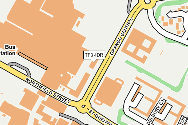
TF3 4DR is located in the Malinslee & Dawley Bank electoral ward, within the unitary authority of Telford and Wrekin and the English Parliamentary constituency of Telford. The Sub Integrated Care Board (ICB) Location is NHS Shropshire, Telford and Wrekin ICB - M2L0M and the police force is West Mercia. This postcode has been in use since January 1993.


GetTheData
Source: OS OpenMap – Local (Ordnance Survey)
Source: OS VectorMap District (Ordnance Survey)
Licence: Open Government Licence (requires attribution)
| Easting | 370026 |
| Northing | 308776 |
| Latitude | 52.675866 |
| Longitude | -2.444747 |
GetTheData
Source: Open Postcode Geo
Licence: Open Government Licence
| Country | England |
| Postcode District | TF3 |
➜ See where TF3 is on a map ➜ Where is Telford? | |
GetTheData
Source: Land Registry Price Paid Data
Licence: Open Government Licence
Elevation or altitude of TF3 4DR as distance above sea level:
| Metres | Feet | |
|---|---|---|
| Elevation | 150m | 492ft |
Elevation is measured from the approximate centre of the postcode, to the nearest point on an OS contour line from OS Terrain 50, which has contour spacing of ten vertical metres.
➜ How high above sea level am I? Find the elevation of your current position using your device's GPS.
GetTheData
Source: Open Postcode Elevation
Licence: Open Government Licence
| Ward | Malinslee & Dawley Bank |
| Constituency | Telford |
GetTheData
Source: ONS Postcode Database
Licence: Open Government Licence
| Matheson House (Grange Central) | Telford Town Centre | 41m |
| Matheson House (Grange Central) | Telford Town Centre | 77m |
| International Centre (St Quentin Gate) | Telford Town Centre | 286m |
| International Centre (St Quentins Gate) | Telford Town Centre | 295m |
| Dunsheath (Dale Acre Way) | Hollinswood | 352m |
| Telford Central Station | 0.6km |
| Oakengates Station | 2km |
| Shifnal Station | 5km |
GetTheData
Source: NaPTAN
Licence: Open Government Licence
GetTheData
Source: ONS Postcode Database
Licence: Open Government Licence


➜ Get more ratings from the Food Standards Agency
GetTheData
Source: Food Standards Agency
Licence: FSA terms & conditions
| Last Collection | |||
|---|---|---|---|
| Location | Mon-Fri | Sat | Distance |
| Telford Centre Post Office | 17:30 | 12:15 | 189m |
| Marks And Spencer | 17:30 | 12:00 | 283m |
| Downmead | 17:15 | 11:15 | 596m |
GetTheData
Source: Dracos
Licence: Creative Commons Attribution-ShareAlike
The below table lists the International Territorial Level (ITL) codes (formerly Nomenclature of Territorial Units for Statistics (NUTS) codes) and Local Administrative Units (LAU) codes for TF3 4DR:
| ITL 1 Code | Name |
|---|---|
| TLG | West Midlands (England) |
| ITL 2 Code | Name |
| TLG2 | Shropshire and Staffordshire |
| ITL 3 Code | Name |
| TLG21 | Telford and Wrekin |
| LAU 1 Code | Name |
| E06000020 | Telford and Wrekin |
GetTheData
Source: ONS Postcode Directory
Licence: Open Government Licence
The below table lists the Census Output Area (OA), Lower Layer Super Output Area (LSOA), and Middle Layer Super Output Area (MSOA) for TF3 4DR:
| Code | Name | |
|---|---|---|
| OA | E00071487 | |
| LSOA | E01014157 | Telford and Wrekin 016D |
| MSOA | E02002943 | Telford and Wrekin 016 |
GetTheData
Source: ONS Postcode Directory
Licence: Open Government Licence
| TF3 4BT | Dean Street | 199m |
| TF3 2BP | Dalford Court | 210m |
| TF3 2DB | Dunsheath | 260m |
| TF3 4JG | Southwater Square | 282m |
| TF3 2BS | Delbury Court | 309m |
| TF3 2BZ | Dunsheath | 352m |
| TF3 2DA | Dunsheath | 358m |
| TF3 2BT | Downton Court | 394m |
| TF3 2BA | Dalelands | 397m |
| TF3 2BX | Dunsheath | 425m |
GetTheData
Source: Open Postcode Geo; Land Registry Price Paid Data
Licence: Open Government Licence